File:NATO AB in France map-fr.svg
Jump to navigation
Jump to search

Size of this PNG preview of this SVG file: 597 × 600 pixels. Other resolutions: 239 × 240 pixels | 478 × 480 pixels | 764 × 768 pixels | 1,019 × 1,024 pixels | 2,038 × 2,048 pixels | 1,025 × 1,030 pixels.
Original file (SVG file, nominally 1,025 × 1,030 pixels, file size: 495 KB)
Captions
Captions
Add a one-line explanation of what this file represents
Summary
[edit]| Description |
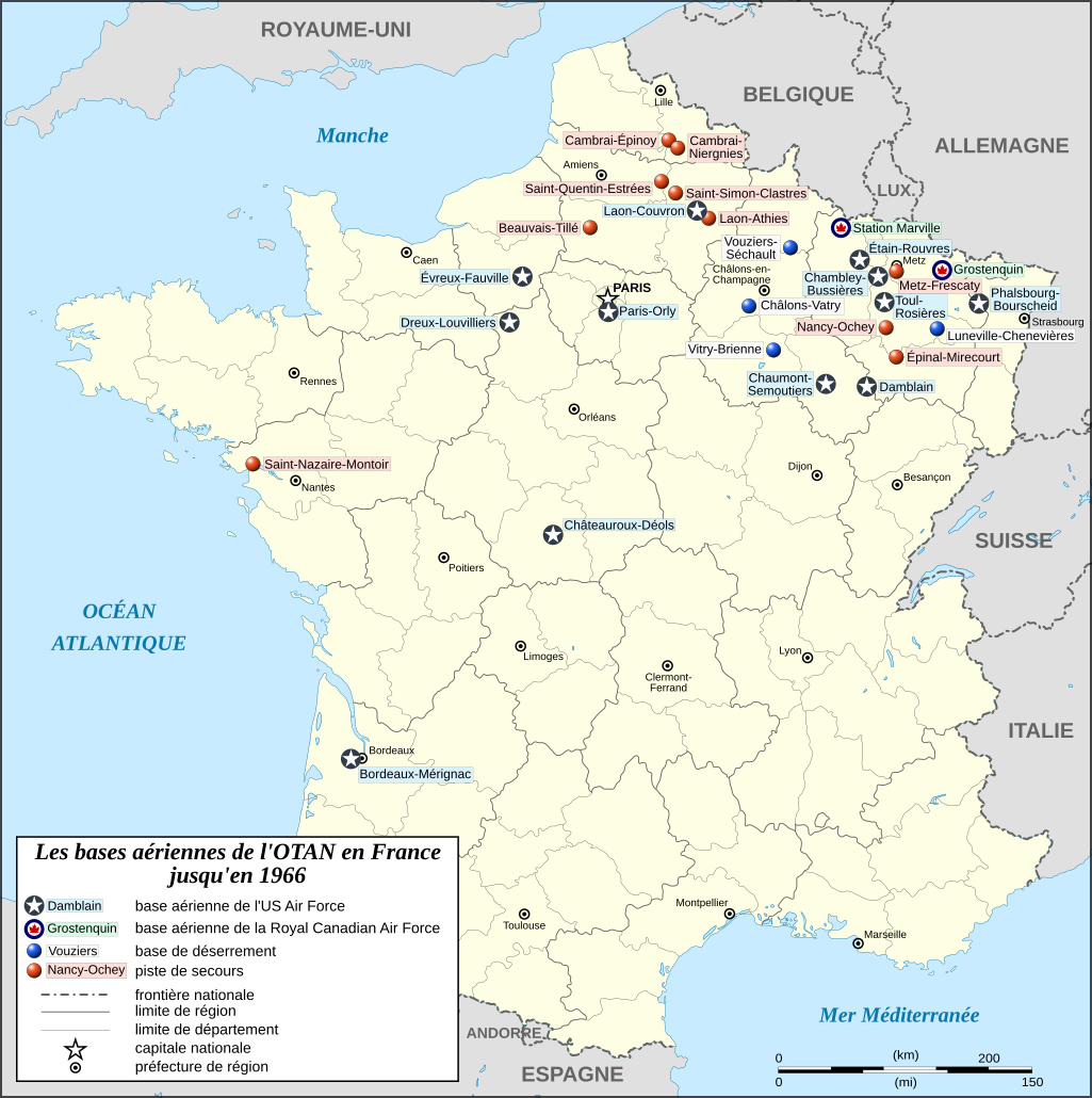
English: Map of the United States Air Force bases, Royal Canadian Air Force bases and NATO Dispersed Operating Bases in France from 1951 to 1966.
Français : Carte des anciennes bases de l'OTAN en France de 1951 à 1966. Lambert-93 projection ; RGF-93 datum |
||
| Date | |||
| Source |
Own work
|
||
| Author | Eric Gaba (Sting - fr:Sting) | ||
| Permission (Reusing this file) |
|
||
| Other versions |
|
||
| SVG development |


.svg)
Licensing
[edit]
I, the copyright holder of this work, hereby publish it under the following licenses:

|
Permission is granted to copy, distribute and/or modify this document under the terms of the GNU Free Documentation License, Version 1.2 or any later version published by the Free Software Foundation; with no Invariant Sections, no Front-Cover Texts, and no Back-Cover Texts. A copy of the license is included in the section entitled GNU Free Documentation License. |
This file is licensed under the Creative Commons Attribution-Share Alike 4.0 International, 3.0 Unported, 2.5 Generic, 2.0 Generic and 1.0 Generic license.
- You are free:
- to share – to copy, distribute and transmit the work
- to remix – to adapt the work
- Under the following conditions:
- attribution – You must give appropriate credit, provide a link to the license, and indicate if changes were made. You may do so in any reasonable manner, but not in any way that suggests the licensor endorses you or your use.
- share alike – If you remix, transform, or build upon the material, you must distribute your contributions under the same or compatible license as the original.
You may select the license of your choice.
File history
Click on a date/time to view the file as it appeared at that time.
| Date/Time | Thumbnail | Dimensions | User | Comment | |
|---|---|---|---|---|---|
| current | 14:30, 22 September 2008 | | 1,025 × 1,030 (495 KB) | Sting (talk | contribs) | Oups ! (scale) |
| 14:45, 12 September 2008 |  | 1,025 × 1,030 (494 KB) | Sting (talk | contribs) | Final corrections | |
| 03:50, 12 September 2008 |  | 1,025 × 1,030 (454 KB) | Sting (talk | contribs) | Correcting bugs | |
| 03:39, 12 September 2008 |  | 1,025 × 1,030 (576 KB) | Sting (talk | contribs) | == Summary == {{Information |Description={{en|Map of the NATO Dispersed Operating Bases in France until 1966.}} {{fr|Carte des [[:fr:anciennes bases de l'OTAN en France|anciennes bases de l'OTAN en Fra |
You cannot overwrite this file.
File usage on Commons
The following 3 pages use this file:
File usage on other wikis
The following other wikis use this file:
- Usage on de.wikipedia.org
- Usage on fr.wikipedia.org
- Organisation du traité de l'Atlantique nord
- 1966 en France
- Histoire de l'Armée de l'air française
- Liste des bases de l'OTAN en France
- Les Ricains
- Wikipédia:Atelier graphique/Cartes/Archives/septembre 2008
- Réintégration de la France dans le commandement intégré de l'OTAN
- 1re Division aérienne du Canada
- 1966 en Lorraine
- Relations entre la France et l'OTAN