File:My Public Lands Roadtrip- New National Conservation Lands Maps Online for Your BLM Roadtrip (19012637205).jpg

Original file (4,470 × 3,282 pixels, file size: 2.51 MB, MIME type: image/jpeg)
Captions
Captions
Summary
[edit].jpg&action=edit§ion=1)
| Description |
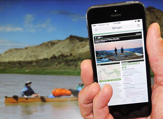
This summer, the #mypubliclandsroadtrip takes you virtually to unique and interesting places across the country on BLM managed public lands. Now, you can better plan your own trip to those locations with online maps. As part of the National Conservation Lands 15th Anniversary celebration, BLM Director Kornze announced the BLM’s new interactive recreational maps. The new maps, available for 42 National Conservation Lands units, provide interactive navigability for BLM recreation sites and trails, along with photos and site-specific information. More maps will be added in the weeks and months to come. Check out the new maps and plan your adventure here: www.blm.gov/conservationlands. |
| Date | |
| Source | My Public Lands Roadtrip: New National Conservation Lands Maps Online for Your BLM Roadtrip |
| Author | Bureau of Land Management |
| Camera location | | View this and other nearby images on: OpenStreetMap |
|---|
.jpg¶ms=047.070722_N_-109.400656_E_globe:Earth_type:camera_source:Flickr_&language=en)
Licensing
[edit].jpg&action=edit§ion=2)
- You are free:
- to share – to copy, distribute and transmit the work
- to remix – to adapt the work
- Under the following conditions:
- attribution – You must give appropriate credit, provide a link to the license, and indicate if changes were made. You may do so in any reasonable manner, but not in any way that suggests the licensor endorses you or your use.
| This image was originally posted to Flickr by mypubliclands at https://flickr.com/photos/91981596@N06/19012637205. It was reviewed on 5 August 2015 by FlickreviewR and was confirmed to be licensed under the terms of the cc-by-2.0. |
| This image is a work of a Bureau of Land Management* employee, taken or made as part of that person's official duties. As a work of the U.S. federal government, the image is in the public domain in the United States. *or predecessor organization |
File history
Click on a date/time to view the file as it appeared at that time.
| Date/Time | Thumbnail | Dimensions | User | Comment | |
|---|---|---|---|---|---|
| current | 18:35, 4 August 2015 | | 4,470 × 3,282 (2.51 MB) | Wilfredor (talk | contribs) | Transferred from Flickr via Flickr2Commons |
You cannot overwrite this file.
File usage on Commons
There are no pages that use this file.
.jpg&oldid=886302636)