File:Mutley Plain, southern end - geograph.org.uk - 449672.jpg
Jump to navigation
Jump to search
No higher resolution available.
Mutley_Plain,_southern_end_-_geograph.org.uk_-_449672.jpg (640 × 427 pixels, file size: 107 KB, MIME type: image/jpeg)
Captions
Captions
Add a one-line explanation of what this file represents
Summary
[edit]
| Description |
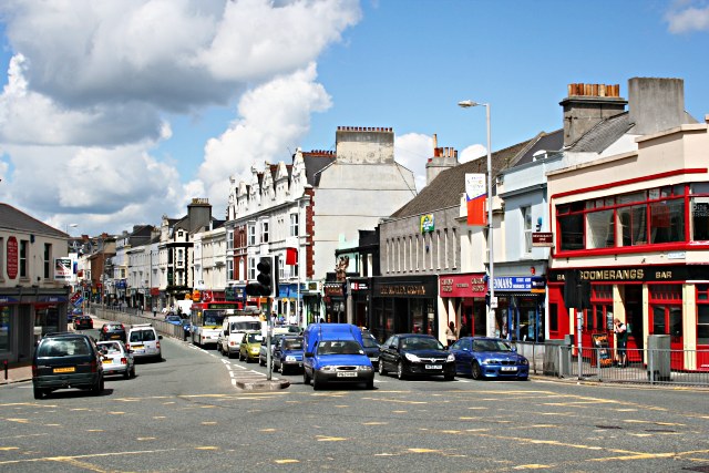
English: Mutley Plain, southern end Mutley Plain has been a transport route for a long time. The plain is a flat col area of between what used to be two tidal creeks to the east and west which made this the only dry route into Plymouth until the creeks were filled in. Drake's leat, which fed water into Plymouth from Dartmoor used to run along the west side of the street. In the Civil war this was the 'no mans land' between the Parliamentarian defenders on the high ground behind me and the Royalist besiegers on the high ground at the far end of the plain, although no direct assault was ever attempted across this land. The huge expansion of Plymouth in the 19th century brought the street largely as we see it today. It quickly became a retail centre for people living in the adjoining terraces although its heyday as a shopping centre was probably during and immediately following the Second World War when the main shopping centres of Plymouth and Devonport were almost completely destroyed by bombing. From the 1950's to the 1970's Mutley Plain slowly declined as a shopping centre with retail stores being slowly replaced by Estate Agents. The huge boom in student numbers in Plymouth in the 1990's, many of whom live in bedsits in the area has led to the opening of more bars, and fast food establishments and revived food-based retailing somewhat. The buildings in the right foreground are a good example of the character of this street now consisting of three bars, a coffee bar, a slot machine arcade and an estate agent. The way things are going I would expect the estate agent to be replaced by another bar sometime soon, which is progress of sorts. I have used the more North American word 'bar' here to describe these new drinking establishments because they are really not traditional pubs at all. |
| Date | |
| Source | From geograph.org.uk |
| Author | Tony Atkin |
| Attribution (required by the license) | Tony Atkin / Mutley Plain, southern end / |
| Camera location | | View this and other nearby images on: OpenStreetMap |
|---|
_heading:0.00&language=en)
| Object location | | View this and other nearby images on: OpenStreetMap |
|---|
_heading:0.00&language=en)
Licensing
[edit]

|
This image was taken from the Geograph project collection. See this photograph's page on the Geograph website for the photographer's contact details. The copyright on this image is owned by Tony Atkin and is licensed for reuse under the Creative Commons Attribution-ShareAlike 2.0 license.
|
This file is licensed under the Creative Commons Attribution-Share Alike 2.0 Generic license.
Attribution: Tony Atkin
- You are free:
- to share – to copy, distribute and transmit the work
- to remix – to adapt the work
- Under the following conditions:
- attribution – You must give appropriate credit, provide a link to the license, and indicate if changes were made. You may do so in any reasonable manner, but not in any way that suggests the licensor endorses you or your use.
- share alike – If you remix, transform, or build upon the material, you must distribute your contributions under the same or compatible license as the original.
File history
Click on a date/time to view the file as it appeared at that time.
| Date/Time | Thumbnail | Dimensions | User | Comment | |
|---|---|---|---|---|---|
| current | 11:58, 4 February 2011 | | 640 × 427 (107 KB) | GeographBot (talk | contribs) | == {{int:filedesc}} == {{Information |description={{en|1=Mutley Plain, southern end Mutley Plain has been a transport route for a long time. The plain is a flat col area of between what used to be two tidal creeks to the east and west which made this the |
You cannot overwrite this file.
File usage on Commons
There are no pages that use this file.