File:Murerplan - Oberes Zürichseegebiet IMG 2383.JPG
Jump to navigation
Jump to search
Size of this preview: 770 × 599 pixels. Other resolutions: 308 × 240 pixels | 617 × 480 pixels | 987 × 768 pixels | 1,280 × 996 pixels | 2,456 × 1,912 pixels.
Original file (2,456 × 1,912 pixels, file size: 2.08 MB, MIME type: image/jpeg)
Captions
Captions
Add a one-line explanation of what this file represents
Summary
[edit]
| Description |
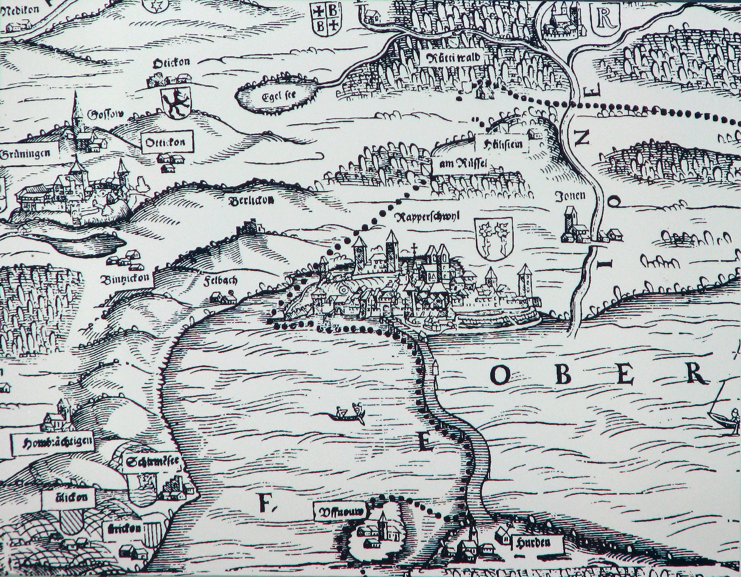
Deutsch: Das obere Zürichseegebiet um Rapperswil (SG) mit den ausgedehnten Wäldern (Rütner und Joner Wald) auf der Karte von Josias Murer aus dem Jahr 1566. Nebst heutigen Gemeinden – u.a. links Grüningen, oben Bubikon und Rüti (ZH), rechts Jonen (Jona SG), unten Insel Ufenau und Hurden (SZ) – sind die Rütner Weiler Hülistein, Rüssel und Matten eingezeichnet. Der Hüllistein ("Hohler Stein") an der Strasse zwischen Rapperswil und Rüti war in jener Zeit weithin als ein Naturschauspiel bekannt, ein Wasserfall unter einer Naturbrücke. Deutlich eingezeichnet sind nebst anderen Details die Holzbrücke Rapperswil-Hurden und rechts die Jona (Ione), welche dem heutigen Ortsteil Jona seinen Namen gab. [Beschreibung teilweise übernommen aus der Schautafel 36 Museen] |
| Date | |
| Source | Stadtarchiv Rapperswil-Jona / fotografiert von einer Schautafel (Grunau) am 29. April 2009 |
| Author | de:Jos Murer, upload by Roland zh |
Licensing
[edit]
|
This work is in the public domain in its country of origin and other countries and areas where the copyright term is the author's life plus 100 years or fewer. | |
| This file has been identified as being free of known restrictions under copyright law, including all related and neighboring rights. | |
File history
Click on a date/time to view the file as it appeared at that time.
| Date/Time | Thumbnail | Dimensions | User | Comment | |
|---|---|---|---|---|---|
| current | 19:47, 18 March 2010 | | 2,456 × 1,912 (2.08 MB) | Roland zh (talk | contribs) | aktualisiert |
| 18:44, 29 April 2009 |  | 2,124 × 1,661 (1.78 MB) | Roland zh (talk | contribs) | == Summary == {{Information |Description={{de|Das obere Zürichseegebiet um Rapperswil (SG) mit den ausgedehnten Wäldern (Rütner und Joner Wald) auf der Karte von Josias Murer aus dem Jahr 1566. Nebst he |
You cannot overwrite this file.
File usage on Commons
The following 4 pages use this file:
- File:Jos Murers Karte des Zürcher Herrschaftsgebiets von 1566 (Ausschnitt) - Stadtmuseum Rapperswil - 'Stadt in Sicht - Rapperswil in Bildern' 2013-10-05 16-05-26 (P7700).JPG
- File:Karte des Zürcher Gebiets 1566 (Kantonskarte Jos Murer) - Rapperswil-Holzbrücke-Obersee - Zentralbibliothek 2011-08-22 15-19-00 ShiftN.jpg
- File:Rapperswil und die Seebrücke auf Jos Murers Karte des Zürcher Herrschaftsgebiets von 1566 (Ausschnitt) - Stadtmuseum Rapperswil - 'Stadt in Sicht - Rapperswil in Bildern' 2013-10-05 16-06-17 (P7700).JPG
- File:Stadtmuseum Rapperswil - 'Stadt in Sicht - Rapperswil in Bildern' - Jos Murers Karte des Zürcher Herrschaftsgebiets von 1566 (Ausschnitt) 2013-10-05 16-05-42 (P7700).JPG
_-_Stadtmuseum_Rapperswil_-_%27Stadt_in_Sicht_-_Rapperswil_in_Bildern%27_2013-10-05_16-05-26_(P7700).JPG)
_-_Rapperswil-Holzbr%C3%BCcke-Obersee_-_Zentralbibliothek_2011-08-22_15-19-00_ShiftN.jpg)
_-_Stadtmuseum_Rapperswil_-_%27Stadt_in_Sicht_-_Rapperswil_in_Bildern%27_2013-10-05_16-06-17_(P7700).JPG)
_2013-10-05_16-05-42_(P7700).JPG)
File usage on other wikis
The following other wikis use this file:
- Usage on ar.wikipedia.org
- Usage on de.wikipedia.org
- Usage on en.wikipedia.org
- Usage on nn.wikipedia.org