File:Murchison River Flood Cyclone Emma.jpg
Jump to navigation
Jump to search
Size of this preview: 452 × 599 pixels. Other resolutions: 181 × 240 pixels | 540 × 716 pixels.
Original file (540 × 716 pixels, file size: 115 KB, MIME type: image/jpeg)
Captions
Captions
Add a one-line explanation of what this file represents
Summary
[edit]
| Description |
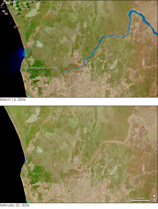
English: The largest flood on record on Australia’s Murchison River was expected to peak at the river’s mouth on March 16, 2006, reported the Australian Broadcasting Corporation. The Moderate Resolution Imaging Spectroradiometer (MODIS) on NASA’s Aqua satellite captured the top image on the afternoon of March 16. On the right side of the image, the upper reaches of the Murchison River are clearly flooded with a wide blue band expanding out from the river’s normal banks. As it enters Kalbarri National Park, the river winds through deep gorges that prevented it from spreading out. Only when it reaches the coast is the river wide again. A bright blue fan of sediment pours from the mouth of the river where mud-laden flood water is draining into the Indian Ocean. The river overflowed after Cyclone Emma inundated the basin with heavy rain on March 1. The excess water took 15 days to drain to the ocean.
The floods near the shore threatened the city of Kalbarri, which sits just south of the river. The floods may also have caused damage to Kalbarri National Park, which is centered around the river and the 80 kilometers of gorges it has cut in the red rock. Even without superimposed borders, the park’s southern boundary is clearly evident in this image. To the south of the river, a stark line separates the green park from the tan and pink land outside the park. The park’s western border is the Indian Ocean. The park’s northern and eastern borders are not visible. |
| Date | |
| Source | http://earthobservatory.nasa.gov/NaturalHazards/view.php?id=16189&oldid=13415 |
| Author | Moderate Resolution Imaging Spectroradiometer (MODIS) |
| Permission (Reusing this file) |
Public Domain |
Licensing
[edit]
| This file is in the public domain in the United States because it was solely created by NASA. NASA copyright policy states that "NASA material is not protected by copyright unless noted". (See Template:PD-USGov, NASA copyright policy page or JPL Image Use Policy.) | ||
 |
Warnings:
|
File history
Click on a date/time to view the file as it appeared at that time.
| Date/Time | Thumbnail | Dimensions | User | Comment | |
|---|---|---|---|---|---|
| current | 15:42, 17 August 2010 | | 540 × 716 (115 KB) | Cyclonebiskit (talk | contribs) | {{Information |Description={{en|1=The largest flood on record on Australia’s Murchison River was expected to peak at the river’s mouth on March 16, 2006, reported the Australian Broadcasting Corporation. The Moderate Resolution Imaging Spectroradiomet |
You cannot overwrite this file.
File usage on Commons
There are no pages that use this file.
File usage on other wikis
The following other wikis use this file:
- Usage on en.wikipedia.org