File:Municipios y zonas de Tenerife.svg
Jump to navigation
Jump to search

Size of this PNG preview of this SVG file: 800 × 600 pixels. Other resolutions: 320 × 240 pixels | 640 × 480 pixels | 1,024 × 768 pixels | 1,280 × 960 pixels | 2,560 × 1,920 pixels.
Original file (SVG file, nominally 1,024 × 768 pixels, file size: 74 KB)
Captions
Captions
Add a one-line explanation of what this file represents
Summary
[edit]
| Description |
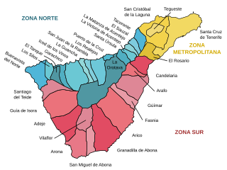
Català: Mapa amb els topònims i zones de l'illa de Tenerife (Illes Canàries)
Español: Mapa con los topónimos marcados de los municipios y zonas de la isla de Tenerife (Islas Canarias)
English: Labeled map with municipalities and zones of Tenerife island (Canary Islands) |
| Date | |
| Source | Own work |
| Author | HansenBCN |
Licensing
[edit]
I, the copyright holder of this work, hereby publish it under the following licenses:

|
Permission is granted to copy, distribute and/or modify this document under the terms of the GNU Free Documentation License, Version 1.2 or any later version published by the Free Software Foundation; with no Invariant Sections, no Front-Cover Texts, and no Back-Cover Texts. A copy of the license is included in the section entitled GNU Free Documentation License. |
| This file is licensed under the Creative Commons Attribution-Share Alike 3.0 Unported license. | ||
| ||
| This licensing tag was added to this file as part of the GFDL licensing update. |
You may select the license of your choice.
File history
Click on a date/time to view the file as it appeared at that time.
| Date/Time | Thumbnail | Dimensions | User | Comment | |
|---|---|---|---|---|---|
| current | 18:32, 15 September 2007 | | 1,024 × 768 (74 KB) | HansenBCN (talk | contribs) | == Summary == {{Information |Description= {{ca|Mapa amb els topònims i zones de l'illa de Tenerife (Illes Canàries)}} {{es|Mapa con los topónimos marcados de los municipios y zonas de la isla de Tenerife (Islas Canarias)}} {{en|Labeled map with municip |
| 18:05, 11 September 2007 |  | 1,024 × 768 (74 KB) | HansenBCN (talk | contribs) | == Summary == {{Information |Description= {{ca|Mapa amb els topònims i zones de l'illa de Tenerife (Illes Canàries)}} {{es|Mapa con los topónimos marcados de los municipios y zonas de la isla de Tenerife (Islas Canarias)}} {{en|Labeled map with municip | |
| 18:01, 11 September 2007 |  | 1,024 × 768 (73 KB) | HansenBCN (talk | contribs) | {{Information |Description= {{ca|Mapa amb els topònims i zones de l'illa de Tenerife (Illes Canàries)}} {{es|Mapa con los topónimos marcados de los municipios y zonas de la isla de Tenerife (Islas Canarias)}} {{en|Labeled map with municipalities and zo |
You cannot overwrite this file.
File usage on Commons
The following page uses this file:
File usage on other wikis
The following other wikis use this file:
- Usage on bg.wikipedia.org
- Usage on ca.wikipedia.org
- Usage on cs.wikipedia.org
- Usage on de.wikipedia.org
- Usage on en.wikipedia.org
- Usage on eo.wikipedia.org
- Usage on es.wikipedia.org
- Usage on frr.wikipedia.org
- Usage on gl.wikipedia.org
- Usage on hu.wikipedia.org
- Usage on nl.wikipedia.org
- Usage on nn.wikipedia.org
- Usage on no.wikipedia.org
- Usage on pl.wikipedia.org
- Usage on sl.wikipedia.org
- Usage on tr.wikipedia.org