File:Municipalities in Baja California peninsula.png
Jump to navigation
Jump to search

Size of this preview: 533 × 600 pixels. Other resolutions: 213 × 240 pixels | 427 × 480 pixels | 683 × 768 pixels | 910 × 1,024 pixels | 1,820 × 2,048 pixels | 8,192 × 9,216 pixels.
Original file (8,192 × 9,216 pixels, file size: 630 KB, MIME type: image/png)
Captions
Captions
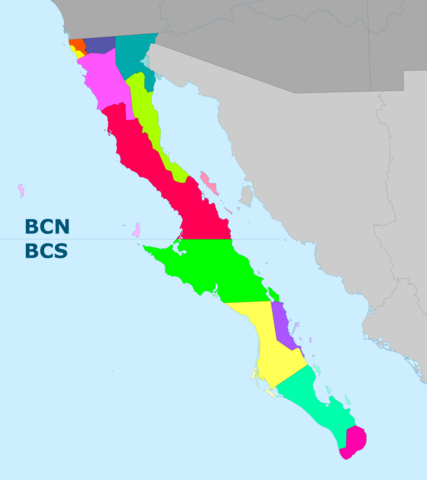
Municipalities in Baja California Peninsula since 2022.
Summary
[edit]
| Description |
English: Municipalities in Baja California Peninsula since 2022; includes both Baja California and Baja California Municipalities.
Español: Municipios en la península de Baja California desde 2022; incluye tanto los municipios de Baja California como los de Baja California Sur. |
| Date | |
| Source | Own work |
| Author | XIC123 |
Licensing
[edit]
I, the copyright holder of this work, hereby publish it under the following license:
This file is licensed under the Creative Commons Attribution-Share Alike 4.0 International license.
- You are free:
- to share – to copy, distribute and transmit the work
- to remix – to adapt the work
- Under the following conditions:
- attribution – You must give appropriate credit, provide a link to the license, and indicate if changes were made. You may do so in any reasonable manner, but not in any way that suggests the licensor endorses you or your use.
- share alike – If you remix, transform, or build upon the material, you must distribute your contributions under the same or compatible license as the original.
File history
Click on a date/time to view the file as it appeared at that time.
| Date/Time | Thumbnail | Dimensions | User | Comment | |
|---|---|---|---|---|---|
| current | 00:07, 2 September 2024 | | 8,192 × 9,216 (630 KB) | XIC123 (talk | contribs) | Variante corregida. |
| 00:04, 2 September 2024 |  | 8,192 × 9,216 (621 KB) | XIC123 (talk | contribs) | Ajuste hacia el norte | |
| 02:47, 1 August 2024 |  | 8,192 × 9,216 (609 KB) | XIC123 (talk | contribs) | Ajuste de límites municipales. | |
| 23:44, 31 July 2024 |  | 8,192 × 9,216 (621 KB) | XIC123 (talk | contribs) | Menor saturación de color en territorios geográficamente no ubicados parcial o totallmente en la Península. | |
| 08:00, 31 July 2024 |  | 8,192 × 9,216 (612 KB) | XIC123 (talk | contribs) | Zoomed out | |
| 18:25, 29 July 2024 |  | 6,144 × 9,216 (258 KB) | XIC123 (talk | contribs) | BCN-BCS Boundary | |
| 07:44, 26 July 2024 |  | 6,144 × 9,216 (245 KB) | XIC123 (talk | contribs) | Enhanced Map | |
| 05:15, 19 May 2024 |  | 5,846 × 8,192 (130 KB) | XIC123 (talk | contribs) | Uploaded own work with UploadWizard |
You cannot overwrite this file.
File usage on Commons
There are no pages that use this file.
File usage on other wikis
The following other wikis use this file:
- Usage on en.wikipedia.org
- Usage on es.wikipedia.org