File:Mullach an Rathain West - geograph.org.uk - 44164.jpg
Jump to navigation
Jump to search
No higher resolution available.
Mullach_an_Rathain_West_-_geograph.org.uk_-_44164.jpg (640 × 462 pixels, file size: 121 KB, MIME type: image/jpeg)
Captions
Captions
Add a one-line explanation of what this file represents
Summary
[edit]
| Description |
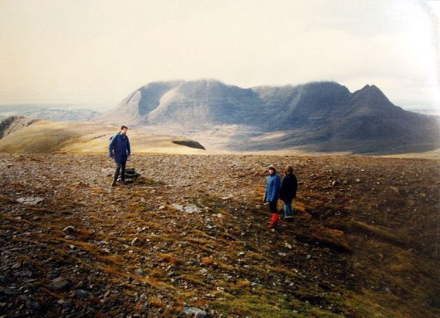
English: Mullach an Rathain West. On the way down the back of Liathach (via Mullach an Rathain, western pinnacle) is seems to plateau out. Don't let that lull you into a feeling of security. There are sheer drops on either side of the mountain. A few minutes after this photo we experienced white-out conditions and freezing temperature. Very frightening.
A good view of Beinn Alligin from here with its familiar horseshoe ridge. Again a formidable climb on a rotten day. This shot of Beinn Alligin also provides good representation of the typical topography of squares NG8559 to NG8761 |
| Date | |
| Source | From geograph.org.uk |
| Author | Simon Johnston |
| Attribution (required by the license) | Simon Johnston / Mullach an Rathain West / |
| Object location | | View this and other nearby images on: OpenStreetMap |
|---|
_&language=en)
Licensing
[edit]

|
This image was taken from the Geograph project collection. See this photograph's page on the Geograph website for the photographer's contact details. The copyright on this image is owned by Simon Johnston and is licensed for reuse under the Creative Commons Attribution-ShareAlike 2.0 license.
|
This file is licensed under the Creative Commons Attribution-Share Alike 2.0 Generic license.
Attribution: Simon Johnston
- You are free:
- to share – to copy, distribute and transmit the work
- to remix – to adapt the work
- Under the following conditions:
- attribution – You must give appropriate credit, provide a link to the license, and indicate if changes were made. You may do so in any reasonable manner, but not in any way that suggests the licensor endorses you or your use.
- share alike – If you remix, transform, or build upon the material, you must distribute your contributions under the same or compatible license as the original.
File history
Click on a date/time to view the file as it appeared at that time.
| Date/Time | Thumbnail | Dimensions | User | Comment | |
|---|---|---|---|---|---|
| current | 16:49, 30 January 2010 | | 640 × 462 (121 KB) | GeographBot (talk | contribs) | == {{int:filedesc}} == {{Information |description={{en|1=Mullach an Rathain West. On the way down the back of Liathach (via Mullach an Rathain, western pinnacle) is seems to plateau out. Don't let that lull you into a feeling of security. There are sheer |
You cannot overwrite this file.
File usage on Commons
There are no pages that use this file.