File:Mukilteo, WA - Plaque for Treaty of Point Elliott.jpg
Jump to navigation
Jump to search

Size of this preview: 398 × 599 pixels. Other resolutions: 159 × 240 pixels | 319 × 480 pixels | 510 × 768 pixels | 680 × 1,024 pixels | 1,360 × 2,048 pixels | 2,848 × 4,288 pixels.
Original file (2,848 × 4,288 pixels, file size: 6.54 MB, MIME type: image/jpeg)
Captions
Captions
Add a one-line explanation of what this file represents
|
This is an image of a place or building that is listed on the National Register of Historic Places in the United States of America. Its reference number is 04000316. |
Summary
[edit]
| Description |
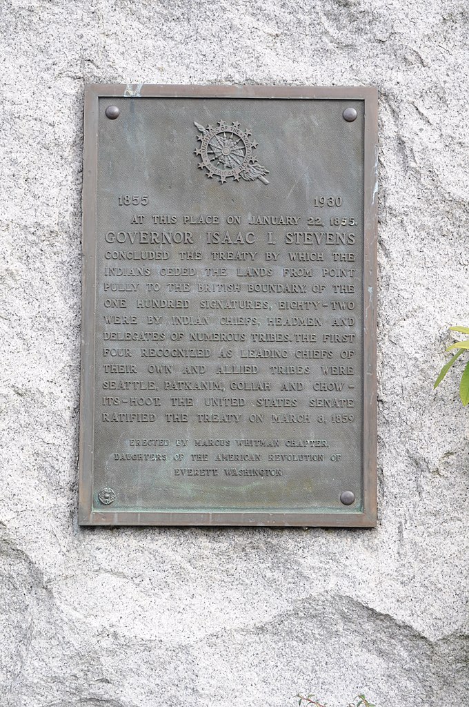
English: Plaque marking the location of the signing of the Treaty of Point Elliott, Lincoln Ave. and 3rd St., Mukilteo, Washington. This monument is listed on the National Register of Historic Places. |
| Date | |
| Source | Photo by Joe Mabel |
| Author | Joe Mabel |
| Object location | | View this and other nearby images on: OpenStreetMap |
|---|
Licensing
[edit]
Joe Mabel, the copyright holder of this work, hereby publishes it under the following licenses:

|
Permission is granted to copy, distribute and/or modify this document under the terms of the GNU Free Documentation License, Version 1.2 or any later version published by the Free Software Foundation; with no Invariant Sections, no Front-Cover Texts, and no Back-Cover Texts. A copy of the license is included in the section entitled GNU Free Documentation License. |
This file is licensed under the Creative Commons Attribution-Share Alike 3.0 Unported license.
Attribution: Joe Mabel
- You are free:
- to share – to copy, distribute and transmit the work
- to remix – to adapt the work
- Under the following conditions:
- attribution – You must give appropriate credit, provide a link to the license, and indicate if changes were made. You may do so in any reasonable manner, but not in any way that suggests the licensor endorses you or your use.
- share alike – If you remix, transform, or build upon the material, you must distribute your contributions under the same or compatible license as the original.
You may select the license of your choice.
File history
Click on a date/time to view the file as it appeared at that time.
| Date/Time | Thumbnail | Dimensions | User | Comment | |
|---|---|---|---|---|---|
| current | 06:21, 2 March 2010 | | 2,848 × 4,288 (6.54 MB) | Jmabel (talk | contribs) | == {{int:filedesc}} == {{Information |Description={{en|Plaque marking the location of the signing of the {{w|Treaty of Point Elliott}}, Mukilteo, Washington.}} |Source=Photo by Joe Mabel |Date=2010-02-28 |Author=Joe Mabel | |
You cannot overwrite this file.
File usage on Commons
There are no pages that use this file.
File usage on other wikis
The following other wikis use this file:
- Usage on en.wikipedia.org
- Usage on es.wikipedia.org
- Usage on fr.wikipedia.org
Metadata
Categories:
- Mukilteo, Washington
- Plaques in Washington (state)
- Monuments and memorials in Washington (state)
- Monuments and memorials to treaties
- National Register of Historic Places in Snohomish County, Washington
- Treaty of Point Elliott
- Plaques referencing 1855 in the United States
- Daughters of the American Revolution plaques
- Isaac Stevens