File:Mughal Historical Map-ar.png
From Wikimedia Commons, the free media repository
Jump to navigation
Jump to search

Size of this preview: 562 × 600 pixels. Other resolutions: 225 × 240 pixels | 450 × 480 pixels.
Original file (800 × 854 pixels, file size: 1.02 MB, MIME type: image/png)
File information
Structured data
Captions
Captions
Add a one-line explanation of what this file represents
Summary
[edit]| DescriptionMughal Historical Map-ar.png |
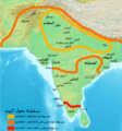
العربية: خارطة سلطنة المغول الهنديَّة وفق دُور توسُّعها في زمن كُل سُلطان. 中文:根據印度莫臥兒蘇丹國在每個蘇丹時期的擴張作用而繪製的地圖。 |
| Date | |
| Source | Derivative from this file |
| Author | |
| Other versions | English |
| This is a retouched picture, which means that it has been digitally altered from its original version. Modifications: Translated to Arabic - عُرِّبت. The original can be viewed here: Mughal Historical Map.png:
|
Licensing
[edit]| Public domainPublic domainfalsefalse |
| I, the copyright holder of this work, release this work into the public domain. This applies worldwide. In some countries this may not be legally possible; if so: I grant anyone the right to use this work for any purpose, without any conditions, unless such conditions are required by law. |
File history
Click on a date/time to view the file as it appeared at that time.
| Date/Time | Thumbnail | Dimensions | User | Comment | |
|---|---|---|---|---|---|
| current | 19:47, 18 January 2024 |  | 800 × 854 (1.02 MB) | باسم (talk | contribs) | updated according to the original file |
| 03:10, 13 February 2016 |  | 800 × 854 (1.19 MB) | Y5 (talk | contribs) | من تغيير خطأ وهو: تاريخ وفاة ظهير الدين بابر بالسنة الهجرية حيث كانت في النسخة القديمة 973 هـ وحولتها إلى 937 هـ | |
| 22:58, 29 June 2015 |  | 800 × 854 (1.37 MB) | باسم (talk | contribs) | User created page with UploadWizard |
You cannot overwrite this file.
File usage on Commons
The following page uses this file:
File usage on other wikis
The following other wikis use this file:
- Usage on ar.wikipedia.org
Metadata
This file contains additional information such as Exif metadata which may have been added by the digital camera, scanner, or software program used to create or digitize it. If the file has been modified from its original state, some details such as the timestamp may not fully reflect those of the original file. The timestamp is only as accurate as the clock in the camera, and it may be completely wrong.
| Horizontal resolution | 37.79 dpc |
|---|---|
| Vertical resolution | 37.79 dpc |