File:MuenchenSBahnMitZweitemTunnel.png
Jump to navigation
Jump to search
Size of this preview: 800 × 565 pixels. Other resolutions: 320 × 226 pixels | 640 × 452 pixels | 1,024 × 723 pixels | 1,280 × 904 pixels | 2,344 × 1,656 pixels.
Original file (2,344 × 1,656 pixels, file size: 454 KB, MIME type: image/png)
Captions
Captions
Add a one-line explanation of what this file represents
Summary
[edit]| Description |
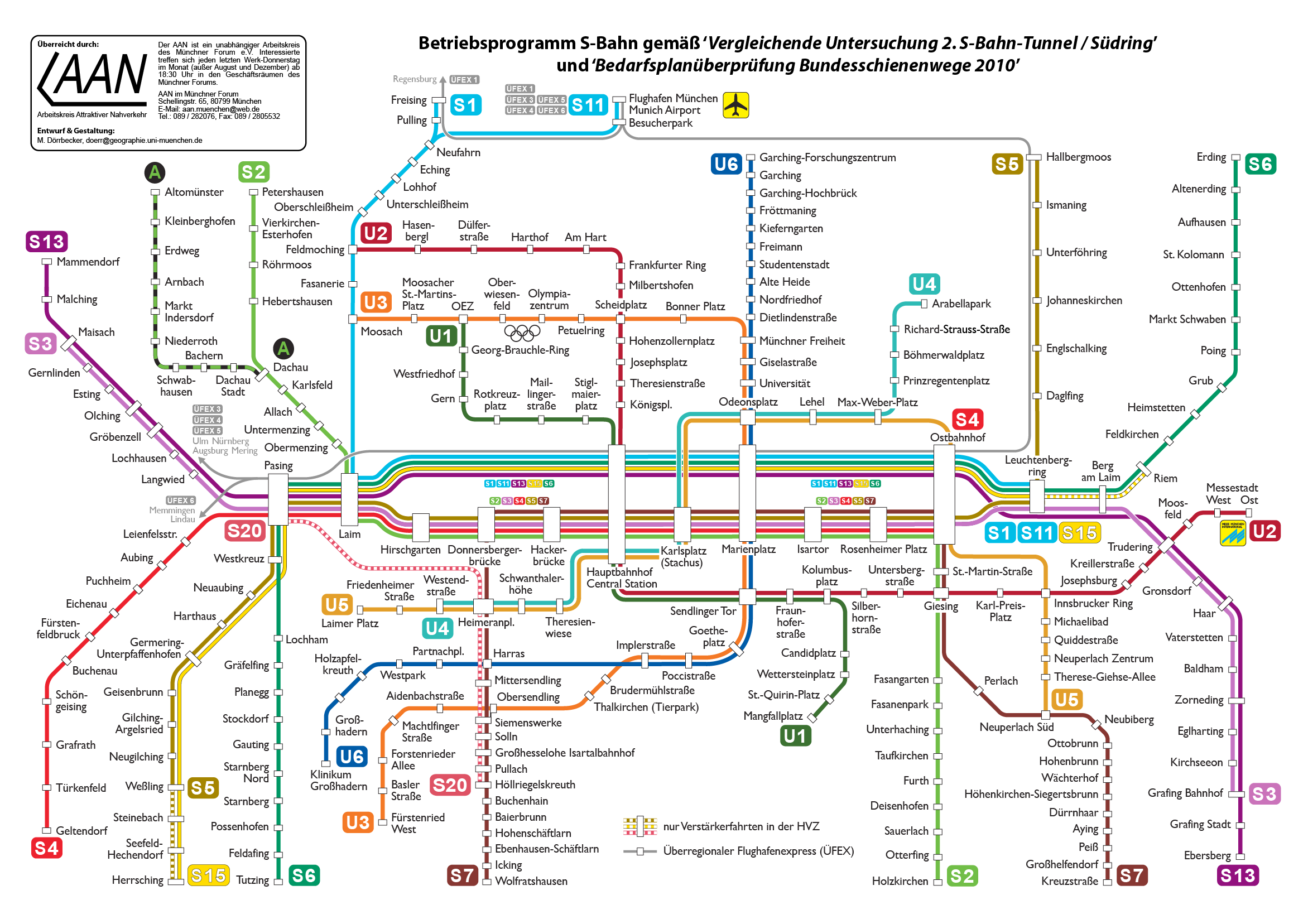
Deutsch: Planungsalternative "Zweiter Tunnel" für die 2. Münchener S-Bahn Stammstrecke
English: Planning variant "The Second Tunnel" for an additional Rapit Transit City Crossing in Munich |
| Date | |
| Source | Own work |
| Author | Maximilian Dörrbecker (Chumwa) |
| Other versions |
Weitere Münchner ÖPNV-Pläne:
|


|
This transport map image could be re-created using vector graphics as an SVG file. This has several advantages; see Commons:Media for cleanup for more information. If an SVG form of this image is available, please upload it and afterwards replace this template with
{{vector version available|new image name}}.
It is recommended to name the SVG file “MuenchenSBahnMitZweitemTunnel.svg”—then the template Vector version available (or Vva) does not need the new image name parameter. |
Licensing
[edit]
I, the copyright holder of this work, hereby publish it under the following license:
This file is licensed under the Creative Commons Attribution-Share Alike 2.5 Generic license.
- You are free:
- to share – to copy, distribute and transmit the work
- to remix – to adapt the work
- Under the following conditions:
- attribution – You must give appropriate credit, provide a link to the license, and indicate if changes were made. You may do so in any reasonable manner, but not in any way that suggests the licensor endorses you or your use.
- share alike – If you remix, transform, or build upon the material, you must distribute your contributions under the same or compatible license as the original.
File history
Click on a date/time to view the file as it appeared at that time.
| Date/Time | Thumbnail | Dimensions | User | Comment | |
|---|---|---|---|---|---|
| current | 07:45, 8 December 2012 | | 2,344 × 1,656 (454 KB) | Chumwa (talk | contribs) | update |
| 22:04, 9 January 2011 |  | 1,758 × 1,242 (342 KB) | Chumwa (talk | contribs) | S7 korrigiert | |
| 20:10, 30 March 2010 |  | 1,758 × 1,242 (342 KB) | Chumwa (talk | contribs) | update | |
| 22:42, 13 December 2009 |  | 1,172 × 828 (193 KB) | Chumwa (talk | contribs) | Plan gemäß der Vergleichenden Untersuchung des Wirtschaftsministeriums angepasst. | |
| 12:13, 20 August 2006 |  | 1,236 × 842 (256 KB) | Chumwa (talk | contribs) | Station Olympiapark in Oberwiesenfeld und Station Nannhofen in Mammendorf umbenannt. Logo der U3-Nord nach Moosach verschoben. | |
| 07:48, 12 February 2006 |  | 1,292 × 881 (272 KB) | Chumwa (talk | contribs) | *'''Description:''' Planung zur 2 S-Bahn-Stammstrecke in München: Alternative "Zweiter Tunnel" *'''Source:''' M. Dörrbecker {{GFDL}} Category:ÖPNV S-Bahn München Category:München Munich Straßenbahn streetcar |
You cannot overwrite this file.
File usage on Commons
The following 66 pages use this file:
- München
- Rapid transit
- User:Chumwa/Gallery
- User:Chumwa/OtherVersions - Karten München
- User:Chumwa/OtherVersions - ÖPNV-Karten München
- File:Administrative boundaries of the borough of Solln in Munich.png
- File:Basiskarte Kiel.png
- File:Gleis 93.jpg
- File:Gleis 96.jpg
- File:Gleis 97b.jpg
- File:Karte Flaucher München.png
- File:Karte München - WirtshausWiesn 2020.png
- File:Karte München Basiskarte.jpg
- File:Karte München Basiskarte.png
- File:Karte München Landnutzung.png
- File:Karte München Schwarzplan.png
- File:Karte München ÖPNV.png
- File:Karte München Übersichtsplan.png
- File:Karte Streetlife München.png
- File:Karte Viktualienmarkt München.png
- File:Karte der Burgfrieden von München.png
- File:Karte der Denkmalschutzensembles in München.jpg
- File:Karte der Gemarkungen in München.png
- File:Karte der Gemarkungen und Stadtbezirke in München.png
- File:Karte der Ortsbezeichnungen in München.png
- File:Karte der Parkstadt Bogenhausen in München.png
- File:Karte der S-Bahn München.png
- File:Karte der Stadtbezirke in München.png
- File:Karte der Stadtbezirke in München in der bis 1992 gültigen Gliederung.png
- File:Karte der Stadtbezirksteile in München.png
- File:Karte der geplanten U9-Spange der U-Bahn München.png
- File:Linienband U-Bahn München.png
- File:Metrobusnetzplan München.png
- File:MuenchenSBahnMitSuedring.png
- File:MuenchenSBahnMitZweitemTunnel.png
- File:München - Basiskarte farbig.pdf
- File:München - Basiskarte farbig.png
- File:München - Basiskarte farbig - mit Nachbargemeinden.jpg
- File:München - Basiskarte farbig - mit Nachbargemeinden.png
- File:München - Basiskarte grau.pdf
- File:München - Basiskarte grau.png
- File:München - Stadtbezirke (Karte).png
- File:Positionskarte München.png
- File:Schnellbahnplan München.png
- File:SchnellbahnschemaplanMuenchenTopographisch2006.png
- File:SchnellbahnschemaplanMuenchenTopographisch2007.png
- File:Stadterweiterungen München.png
- File:StrassenbahnSchemaplanMuenchen1997.png
- File:StrassenbahnnetzMuenchen1964.jpg
- File:Straßenbahn-Linienplan München.png
- File:Straßenbahnnetzplan München.png
- File:Streckennetz der S-Bahn München.jpg
- File:U-Bahn-Plan München.png
- File:UBahnLinienbandMuenchen2006.png
- File:UBahnLinienbandMuenchen2007.png
- File:UBahnMuenchen Stammstrecke3.png
- File:UBahnSchemaplanMuenchenTopographisch2006.png
- File:UBahnSchemaplanMuenchenTopographisch2007.png
- File:UBahnSchemaplanMuenchenTopographisch2008.png
- File:VerkehrsnetzMuenchen2006.png
- File:VerkehrsnetzMuenchen2007.png
- File:VerkehrsnetzMünchen2005.png
- File:Verkehrsnetz München.png
- File:Verkehrsnetz München 2007.png
- File:Westpark München (Karte).png
- File:Westpark München zur IGA 1983 (Karte).png
.png)
.png)
.png)
File usage on other wikis
The following other wikis use this file:
- Usage on en.wikipedia.org
- Usage on hu.wikipedia.org