File:Mt Myoko from Northeast.JPG
Jump to navigation
Jump to search

Size of this preview: 800 × 600 pixels. Other resolutions: 320 × 240 pixels | 640 × 480 pixels | 1,024 × 768 pixels | 1,280 × 960 pixels | 2,352 × 1,764 pixels.
Original file (2,352 × 1,764 pixels, file size: 1.97 MB, MIME type: image/jpeg)
Captions
Captions
Add a one-line explanation of what this file represents
Summary
[edit]
| Description |
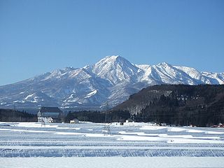
English: Mount Myoko (Myoko-san) as seen from the ESE. Taken from Okashinden, Myoko, Niigata Prefecture.
|
| Date | |
| Source | Own work |
| Author | 西城越 |
| Camera location | | View this and other nearby images on: OpenStreetMap |
|---|
Licensing
[edit]
| I, the copyright holder of this work, release this work into the public domain. This applies worldwide. In some countries this may not be legally possible; if so: I grant anyone the right to use this work for any purpose, without any conditions, unless such conditions are required by law. |
File history
Click on a date/time to view the file as it appeared at that time.
| Date/Time | Thumbnail | Dimensions | User | Comment | |
|---|---|---|---|---|---|
| current | 21:14, 10 January 2010 | | 2,352 × 1,764 (1.97 MB) | 西城越 (talk | contribs) | {{Information |Description={{en|1=Mt.Myoko and its somma seen from Haradori area, Myoko city, Niigata prefecture(Northeast direction).}} {{ja|1=新潟県妙高市原通地区(北西方向)より見た妙高山と外輪山。}} |Source=taken by submitt |
You cannot overwrite this file.
File usage on Commons
The following 2 pages use this file:
File usage on other wikis
The following other wikis use this file:
- Usage on ceb.wikipedia.org
- Usage on cs.wikipedia.org
- Usage on de.wikipedia.org
- Usage on en.wikipedia.org
- Usage on es.wikipedia.org
- Usage on eu.wikipedia.org
- Usage on fr.wikipedia.org
- Usage on id.wikipedia.org
- Usage on ja.wikipedia.org
- Usage on pnb.wikipedia.org
- Usage on vi.wikipedia.org
- Usage on www.wikidata.org
- Usage on zh.wikipedia.org