File:Mt Everest north face marked01.png
Jump to navigation
Jump to search
No higher resolution available.
Mt_Everest_north_face_marked01.png (720 × 540 pixels, file size: 617 KB, MIME type: image/png)
Captions
Captions
Add a one-line explanation of what this file represents
Summary
[edit]
| Description |
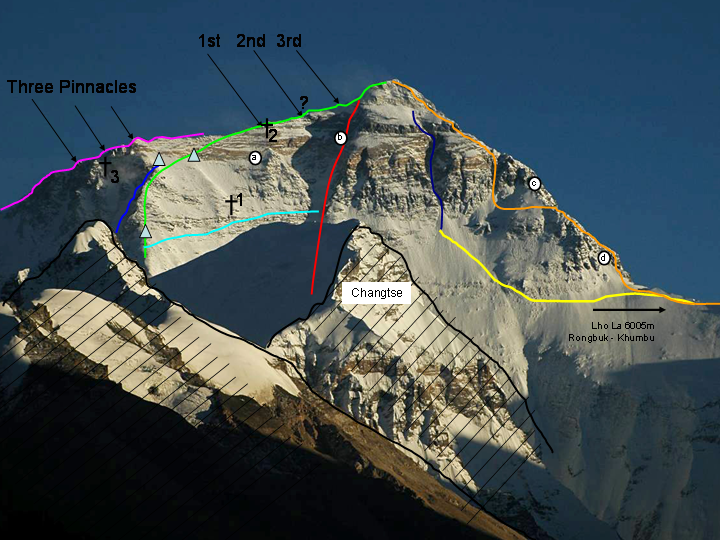
English: The north face of Mount Everest with important routes and features |
| Date | |
| Source | derived form "MT. Everest" , Wikipedia, modified by adding lines etc. |
| Author | BerndB |
Legend
[edit]
Green line
|
Standard route from north, mainly identical with Mallory's route in 1924; high camps on c.7700 m and 8300 m (indicated by two triangles), present day camp on 8300 m is located a bit further west. |
Navy blue line
|
Zakharov Couloir. |
Light blue line
|
Messner's traverse from north ridge to Norton Couloir in 1980 ("Everest Solo by Fair Means") w/o O2. |
Red line
|
Great Couloir or Norton Couloir. |
Purple line
|
Complete northeast ridge with Three Pinnacles; Japanese route to the top. Climbed before by Russell Brice & Comp., but only the purple-marked part of the ridge, without going to the summit; decent via standard route. |
Yellow line and Dark blue line
|
American 1963, "The West Ridge". |
Orange line
|
Yugoslavian route, 1979. |
Dark blue line
|
Hornbein Couloir. |
| †1 | Resting place of Mallory's body, discovered in 1999 (graveyard with more than 15 bodies, according to Conrad Anker). |
| †2 | 1st Step, resting place of Francys Arsentiev, "Green Boots", David Sharp. |
| †3 | 2nd Pinnacle, resting place of Peter Boardman (+1982) in 1992. |
| ? | 2nd step, base at 8605 m, c.30 m high, (difficulty: 5–9/10). |
| (a) | Point at ca. 8325 m, reached by George Ingle Finch with supplementary oxygen in 1922. |
| (b) | Point at 8572 m on the western side of the Couloir, reached by Edward Felix Norton 1924 without supplementary oxygen (Norton preferred climbing the wall rather than climbing the ridge). |
| (c) | Area left out by the Yugoslavian party on their "complete West Ridge" ascent in 1979. |
| (d) | Difficult area that forced Americans, Tom Hornbein and Willi Unsoeld, to traverse from the west ridge to the north face in 1963. |
Licensing
[edit]

|
Permission is granted to copy, distribute and/or modify this document under the terms of the GNU Free Documentation License, Version 1.2 or any later version published by the Free Software Foundation; with no Invariant Sections, no Front-Cover Texts, and no Back-Cover Texts. A copy of the license is included in the section entitled GNU Free Documentation License. |
| This file is licensed under the Creative Commons Attribution-Share Alike 3.0 Unported license. | ||
| ||
| This licensing tag was added to this file as part of the GFDL licensing update. |
Original upload log
[edit]
The original description page was here. All following user names refer to en.wikipedia.
- 2008-11-29 20:36 BerndB 720×540× (631868 bytes) {{Information |Description=Mount Everest north face w. important routes and sport |Source=derived form "MT. Everest" , Wikipedia, modified by adding lines etc. |Date=Nov 29, 2008 |Author=BerndB |Permission= |other_versions= }}
File history
Click on a date/time to view the file as it appeared at that time.
| Date/Time | Thumbnail | Dimensions | User | Comment | |
|---|---|---|---|---|---|
| current | 15:12, 30 April 2014 | | 720 × 540 (617 KB) | Sandip90 (talk | contribs) | Transferred from en.wikipedia |
You cannot overwrite this file.
File usage on Commons
There are no pages that use this file.