File:Mt. Pico De Loro Monolith.jpg
Original file (1,741 × 1,243 pixels, file size: 376 KB, MIME type: image/jpeg)
Captions
Summary
[edit]DescriptionMt. Pico De Loro Monolith.jpg |
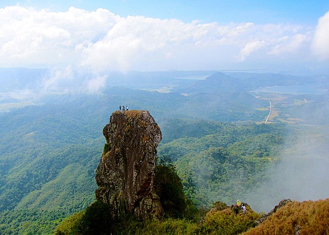
English: At the summit of Mt. Pico De Loro is a monolith. Also known as the Parrot's beak. It is a 60-meter natural rock formation often scaled by rock climbers. Shot by Schadow1 Expeditions during its mapping expedition to Pico De Loro of 2013. |
||||
Date | |||||
Source | Own work | ||||
Author | Ervin Malicdem | ||||
Permission (Reusing this file) |
I, the copyright holder of this work, hereby publish it under the following licenses:
This file is licensed under the Creative Commons Attribution-Share Alike 4.0 International license.
You may select the license of your choice.
|
Camera location | 14° 12′ 51.27″ N, 120° 38′ 47.05″ E | View this and other nearby images on: OpenStreetMap | 14.214243; 120.646402 |
---|
Initially published at Schadow1 Expeditions article available at http://www.s1expeditions.com/2013/01/pico-de-loro-summit-664masl-part-2.html
File history
Click on a date/time to view the file as it appeared at that time.
Date/Time | Thumbnail | Dimensions | User | Comment | |
---|---|---|---|---|---|
current | 14:05, 17 January 2015 | 1,741 × 1,243 (376 KB) | Schadow1 (talk | contribs) | change to generic | |
12:46, 17 January 2015 | 1,920 × 1,371 (487 KB) | Schadow1 (talk | contribs) | User created page with UploadWizard |
You cannot overwrite this file.
File usage on Commons
The following 2 pages use this file:
File usage on other wikis
The following other wikis use this file:
- Usage on en.wikipedia.org
- Usage on hu.wikipedia.org
- Usage on ilo.wikipedia.org
- Usage on ka.wikipedia.org
- Usage on pt.wikipedia.org
- Usage on www.wikidata.org
Metadata
This file contains additional information such as Exif metadata which may have been added by the digital camera, scanner, or software program used to create or digitize it. If the file has been modified from its original state, some details such as the timestamp may not fully reflect those of the original file. The timestamp is only as accurate as the clock in the camera, and it may be completely wrong.
Camera manufacturer | Canon |
---|---|
Camera model | Canon PowerShot D20 |
Exposure time | 1/320 sec (0.003125) |
F-number | f/8 |
ISO speed rating | 200 |
Date and time of data generation | 10:46, 5 January 2013 |
Lens focal length | 5 mm |
Latitude | 14° 12′ 51.27″ N |
Longitude | 120° 38′ 47.05″ E |
Altitude | 659.4 meters above sea level |
Orientation | Normal |
Horizontal resolution | 180 dpi |
Vertical resolution | 180 dpi |
File change date and time | 10:46, 5 January 2013 |
Y and C positioning | Centered |
Exif version | 2.3 |
Date and time of digitizing | 10:46, 5 January 2013 |
Meaning of each component |
|
APEX shutter speed | 8.3128829536528 |
APEX aperture | 6 |
APEX exposure bias | 0 |
Maximum land aperture | 3.9269482450922 APEX (f/3.9) |
Metering mode | Pattern |
Flash | Flash did not fire, compulsory flash suppression |
Supported Flashpix version | 1 |
Color space | sRGB |
Focal plane X resolution | 16,393.442622951 |
Focal plane Y resolution | 16,393.442622951 |
Focal plane resolution unit | inches |
Sensing method | One-chip color area sensor |
File source | Digital still camera |
Custom image processing | Normal process |
Exposure mode | Auto exposure |
White balance | Auto white balance |
Digital zoom ratio | 1 |
Scene capture type | Standard |
GPS time (atomic clock) | 02:46:11.376 |
Receiver status | Measurement in progress |
Geodetic survey data used | WGS-84 |
GPS date | 5 January 2013 |
GPS tag version | 0.0.3.2 |