File:Mt-map.jpg
Jump to navigation
Jump to search
No higher resolution available.
Mt-map.jpg (351 × 377 pixels, file size: 41 KB, MIME type: image/jpeg)
Captions
Captions
Add a one-line explanation of what this file represents
Summary
[edit]

See also Image:Mt-map.png.
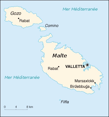
This image was copied from wikipedia:fr. The original description was:
Plan de l'île de Malte
[edit]
Origine
[edit]
CIA World Factbook Copié du wiki en: http://en.wikipedia.org/wiki/Image:Mt-map.jpg
Modifiée (traduction française) par Arnaudus
Licensing
[edit]
This image is in the public domain because it contains materials that originally came from the United States Central Intelligence Agency's World Factbook.
|
 |
| date/time | username | resolution | size | edit summary |
|---|---|---|---|---|
This PD file was uploaded by the bot User:Loveless and is being checked for the following reasons:
|
File history
Click on a date/time to view the file as it appeared at that time.
| Date/Time | Thumbnail | Dimensions | User | Comment | |
|---|---|---|---|---|---|
| current | 13:50, 29 September 2006 | | 351 × 377 (41 KB) | Loveless (talk | contribs) | This image was copied from wikipedia:fr. The original description was: == Plan de l'île de Malte == == Origine == CIA World Factbook Copié du wiki en: http://en.wikipedia.org/wiki/Image:Mt-map.jpg Modifiée (traduction française) par [[:fr:Utilisat |
You cannot overwrite this file.
File usage on Commons
There are no pages that use this file.
File usage on other wikis
The following other wikis use this file:
- Usage on fr.wikipedia.org