File:Mpicchumapa-de.jpg
Jump to navigation
Jump to search
No higher resolution available.
Mpicchumapa-de.jpg (592 × 560 pixels, file size: 120 KB, MIME type: image/jpeg)
Captions
Captions
Add a one-line explanation of what this file represents
| Description |
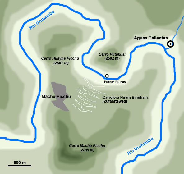
Deutsch: Lage von Machu Picchu bei Aguas Calientes
English: Machu Picchu Location
Español: Mapa de ubicación de Machu Picchu con respecto a los cerros Machu y Huayna Picchu y el pueblo de Aguas Calientes. |
| Date | (UTC) |
| Source | |
| Author |
|
| This is a retouched picture, which means that it has been digitally altered from its original version. Modifications: translated. The original can be viewed here: Mpicchumapa02.jpg:
|
I, the copyright holder of this work, hereby publish it under the following licenses:
This file is licensed under the Creative Commons Attribution-Share Alike 2.5 Generic, 2.0 Generic and 1.0 Generic license.
- You are free:
- to share – to copy, distribute and transmit the work
- to remix – to adapt the work
- Under the following conditions:
- attribution – You must give appropriate credit, provide a link to the license, and indicate if changes were made. You may do so in any reasonable manner, but not in any way that suggests the licensor endorses you or your use.
- share alike – If you remix, transform, or build upon the material, you must distribute your contributions under the same or compatible license as the original.
| This file is licensed under the Creative Commons Attribution-Share Alike 3.0 Unported license. | ||
| ||
| This licensing tag was added to this file as part of the GFDL licensing update. |

|
Permission is granted to copy, distribute and/or modify this document under the terms of the GNU Free Documentation License, Version 1.2 or any later version published by the Free Software Foundation; with no Invariant Sections, no Front-Cover Texts, and no Back-Cover Texts. A copy of the license is included in the section entitled GNU Free Documentation License. |
You may select the license of your choice.
Original upload log
[edit]
This image is a derivative work of the following images:
- File:Mpicchumapa02.jpg licensed with Cc-by-sa-2.5,2.0,1.0, Cc-by-sa-3.0-migrated, GFDL
- 2007-03-03T17:07:27Z Pablopablo 592x560 (181157 Bytes) {{Information |Description=ubicación de Machu Picchu en el Cañón del urubamba |Source=trabajo propio |Date=2007 |Author=pablopablo }}
- 2007-02-25T19:30:37Z Pablopablo 592x560 (88016 Bytes) Mapa de ubicación de Machu Picchu con respecto a los cerros Machu y Huayna Picchu y el pueblo de Aguas Calientes.
Uploaded with derivativeFX
File history
Click on a date/time to view the file as it appeared at that time.
| Date/Time | Thumbnail | Dimensions | User | Comment | |
|---|---|---|---|---|---|
| current | 15:30, 13 January 2011 | | 592 × 560 (120 KB) | NordNordWest (talk | contribs) | {{Information |Description={{de|Lage von Machu Picchu bei Aguas Calientes}} {{en|Machu Picchu Location}} {{es|Mapa de ubicación de Machu Picchu con respecto a los cerros Machu y Huayna Picchu y el pueblo de Aguas Calientes.}} |Source=*[[:File:Mpicchumapa |
You cannot overwrite this file.
File usage on Commons
There are no pages that use this file.
File usage on other wikis
The following other wikis use this file:
- Usage on de.wikipedia.org
- Usage on nl.wikipedia.org