File:Mount Tanigawadake Relief Map, SRTM-1 (Japanese).jpg
Jump to navigation
Jump to search

Size of this preview: 800 × 600 pixels. Other resolutions: 320 × 240 pixels | 640 × 480 pixels | 1,024 × 768 pixels | 1,280 × 960 pixels | 1,600 × 1,200 pixels.
Original file (1,600 × 1,200 pixels, file size: 1.09 MB, MIME type: image/jpeg)
Captions
Captions
Add a one-line explanation of what this file represents
| Description |
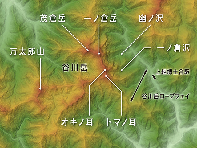
English: Relief map of Mount Tanigawadake, Gunma Prefecture & Niigata Prefecture, Prefecture, Honshu, Japan. Data from "SRTM-1 (30m Mesh) Ver.3 2014".
|
||
| Date | |||
| Source | NASA's Shuttle Radar Topography Mission (SRTM-1 "30m Mesh") | ||
| Author |
Batholith (Wikimedia Commons) Batholith (Wikipedia) |
||
| Permission (Reusing this file) |
|
||
| Other versions |
 |
This image uses high-resolution digital topography data from NASA's Shuttle Radar Topography Mission (SRTM) at JPL-Caltech [1]. It is in the public domain in the United States.
|
 | |
File history
Click on a date/time to view the file as it appeared at that time.
| Date/Time | Thumbnail | Dimensions | User | Comment | |
|---|---|---|---|---|---|
| current | 10:03, 4 March 2016 | | 1,600 × 1,200 (1.09 MB) | Batholith (talk | contribs) | {{Information |Description= {{en|Relief map of Mount Tanigawadake, Gunma Prefecture & Niigata Prefecture, Prefecture, Honshu, Japan. Data fr... |
You cannot overwrite this file.
File usage on Commons
The following 3 pages use this file:
File usage on other wikis
The following other wikis use this file:
.jpg&oldid=453961074)