File:Mount St. Helens, Landsat 8.jpeg
Jump to navigation
Jump to search

Size of this preview: 600 × 600 pixels. Other resolutions: 240 × 240 pixels | 480 × 480 pixels | 768 × 768 pixels | 1,024 × 1,024 pixels | 2,048 × 2,048 pixels | 4,096 × 4,096 pixels.
Original file (4,096 × 4,096 pixels, file size: 6.5 MB, MIME type: image/jpeg)
Captions
Captions
Add a one-line explanation of what this file represents
Summary
[edit]
| Description |
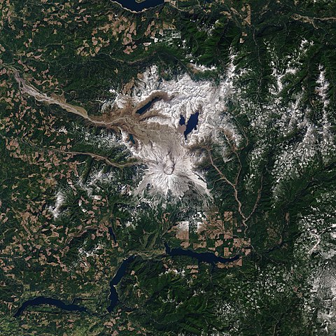
Forty years have passed since a tremendous blast at Mount St. Helens—the deadliest eruption in U.S. history—transformed the landscape for hundreds of square miles in the Pacific Northwest. Satellite images acquired in the days around the eruption on May 18, 1980, helped scientists understand the event; images acquired over the past four decades have given them insight into how a landscape recovers. The image above, acquired with the Operational Land Imager (OLI) on Landsat 8, shows the volcano in southwest Washington on April 17, 2020. Seasonal snow still blanketed its flanks despite the spring sunshine. By August, most of the snow on the mountain will melt. The image is the most recent, cloud-free view of the mountain from Landsat 8, which acquires images of any given place on Earth about once every two weeks. |
| Date | |
| Source | https://earthobservatory.nasa.gov/images/146735/mount-st-helens |
| Author | NASA Earth Observatory images by Joshua Stevens, Robert Simmon, and Jesse Allen, using Landsat data from the U.S. Geological Survey. Story by Kathryn Hansen. |
Licensing
[edit]
| This file is in the public domain in the United States because it was solely created by NASA. NASA copyright policy states that "NASA material is not protected by copyright unless noted". (See Template:PD-USGov, NASA copyright policy page or JPL Image Use Policy.) | ||
 |
Warnings:
|
File history
Click on a date/time to view the file as it appeared at that time.
| Date/Time | Thumbnail | Dimensions | User | Comment | |
|---|---|---|---|---|---|
| current | 02:46, 10 March 2021 | | 4,096 × 4,096 (6.5 MB) | StellarHalo (talk | contribs) | {{Information |Description=Forty years have passed since a tremendous blast at Mount St. Helens—the deadliest eruption in U.S. history—transformed the landscape for hundreds of square miles in the Pacific Northwest. Satellite images acquired in the days around the eruption on May 18, 1980, helped scientists understand the event; images acquired over the past four decades have given them insight into how a landscape recovers. The image above, acquired with the Operational Land Imager (OLI) on... |
You cannot overwrite this file.
File usage on Commons
There are no pages that use this file.