File:Mount Kenya Climbing Routes and Huts photomap-en.svg
Jump to navigation
Jump to search

Size of this PNG preview of this SVG file: 750 × 600 pixels. Other resolutions: 300 × 240 pixels | 600 × 480 pixels | 961 × 768 pixels | 1,280 × 1,023 pixels | 2,560 × 2,047 pixels | 1,492 × 1,193 pixels.
Original file (SVG file, nominally 1,492 × 1,193 pixels, file size: 985 KB)
Captions
Captions
Add a one-line explanation of what this file represents
Any autoconfirmed user can overwrite this file from the same source. Please ensure that overwrites comply with the guideline.
Summary
[edit]
| Description |
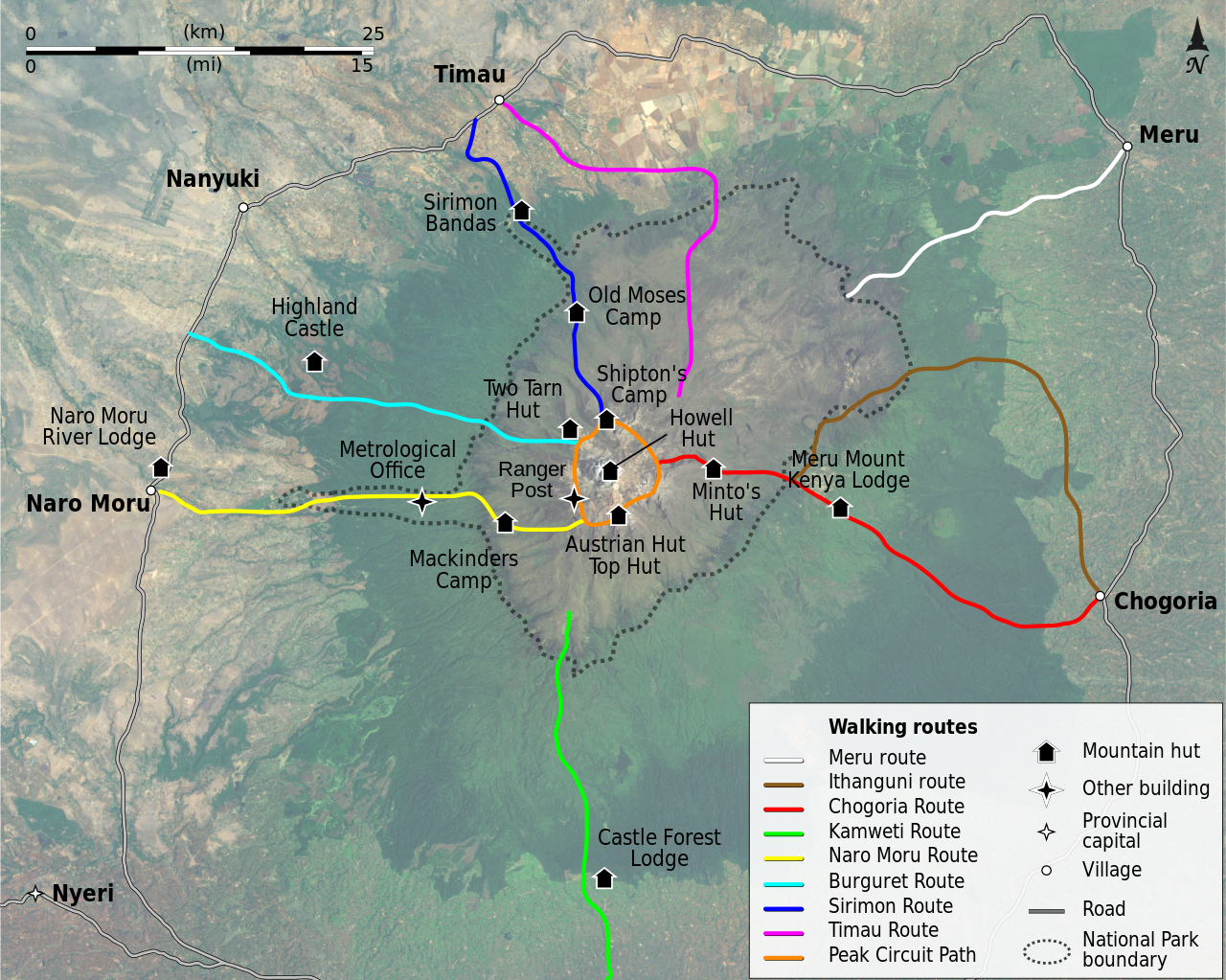
English: Map of the climbing routes and huts around the Mount Kenya. Français : Carte des itinéraires et des gîtes et refuges autour du Mont Kenya.
|
| Date | (UTC) |
| Source | |
| Author |
|
| Other versions | |
| SVG | W3C-validity not checked. |
| Camera location | | View this and other nearby images on: OpenStreetMap |
|---|
| This is a retouched picture, which means that it has been digitally altered from its original version. Modifications: Translated key to English. The original can be viewed here: Mount Kenya Climbing Routes and Huts photomap-fr.svg:
|
Licensing
[edit]
I, the copyright holder of this work, hereby publish it under the following licenses:
This file is licensed under the Creative Commons Attribution-Share Alike 3.0 Unported, 2.5 Generic, 2.0 Generic and 1.0 Generic license.
- You are free:
- to share – to copy, distribute and transmit the work
- to remix – to adapt the work
- Under the following conditions:
- attribution – You must give appropriate credit, provide a link to the license, and indicate if changes were made. You may do so in any reasonable manner, but not in any way that suggests the licensor endorses you or your use.
- share alike – If you remix, transform, or build upon the material, you must distribute your contributions under the same or compatible license as the original.

|
Permission is granted to copy, distribute and/or modify this document under the terms of the GNU Free Documentation License, Version 1.2 or any later version published by the Free Software Foundation; with no Invariant Sections, no Front-Cover Texts, and no Back-Cover Texts. A copy of the license is included in the section entitled GNU Free Documentation License. |
You may select the license of your choice.
Original upload log
[edit]
This image is a derivative work of the following images:
- File:Mount_Kenya_Climbing_Routes_and_Huts_photomap-fr.svg licensed with Cc-by-sa-3.0,2.5,2.0,1.0, GFDL
- 2008-04-29T19:38:17Z Sémhur 1492x1193 (1014953 Bytes) Correction de la route Naro Moru, ajout de refuges
- 2008-04-29T18:38:07Z Sémhur 1492x1193 (1014150 Bytes) == Description == {{Information |Description= {{en|Map of the climbing routes and huts around the [[:en:Mount Kenya|Mount Kenya]], in french.}} {{fr|Carte des itinéraires et des gîtes et refuges autour du [[:fr:Mont Kenya|M
Uploaded with derivativeFX
File history
Click on a date/time to view the file as it appeared at that time.
| Date/Time | Thumbnail | Dimensions | User | Comment | |
|---|---|---|---|---|---|
| current | 18:23, 14 April 2024 | | 1,492 × 1,193 (985 KB) | Chmykh (talk | contribs) | fix Shipton's Camp and Old Moses Camp location |
| 08:40, 24 April 2009 |  | 1,492 × 1,193 (985 KB) | Sémhur (talk | contribs) | Updating fonts, hut icons, Shipton's Camp location and adding Old Moses Camp. | |
| 10:36, 2 April 2009 |  | 1,492 × 1,193 (992 KB) | Mehmet Karatay (talk | contribs) | {{Information |Description={{en|Map of the climbing routes and huts around the Mount Kenya, in french.}} {{fr|Carte des itinéraires et des gîtes et refuges autour du Mont Kenya.}} |Source=*[[:File:Mount_Kenya_Climb |
You cannot overwrite this file.
File usage on Commons
The following page uses this file:
File usage on other wikis
The following other wikis use this file:
- Usage on ast.wikipedia.org
- Usage on bn.wikipedia.org
- Usage on en.wikipedia.org
- Usage on es.wikipedia.org
- Usage on ro.wikipedia.org
- Usage on sv.wikipedia.org