File:Mount Batur and Lake Batur - 2015.02 - panoramio.jpg
Jump to navigation
Jump to search

Size of this preview: 799 × 289 pixels. Other resolutions: 320 × 116 pixels | 640 × 232 pixels | 1,024 × 370 pixels | 1,280 × 463 pixels | 4,697 × 1,699 pixels.
Original file (4,697 × 1,699 pixels, file size: 2.49 MB, MIME type: image/jpeg)
Captions
Captions
Add a one-line explanation of what this file represents
Summary
[edit]
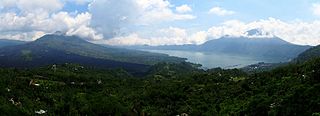
| Description | Mount Batur and Lake Batur - 2015.02 | ||
| Date | Taken on 28 February 2015 | ||
| Source | https://web.archive.org/web/20161031030705/http://www.panoramio.com/photo/122001718 | ||
| Author | rheins | ||
| Permission (Reusing this file) |
This file is licensed under the Creative Commons Attribution 3.0 Unported license. Attribution: rheins
|
||
| Panoramio Tags | Kintamani, 印度尼西亚 - Indonesia |
| Camera location | | View this and other nearby images on: OpenStreetMap |
|---|
File history
Click on a date/time to view the file as it appeared at that time.
| Date/Time | Thumbnail | Dimensions | User | Comment | |
|---|---|---|---|---|---|
| current | 16:44, 31 May 2017 | 4,697 × 1,699 (2.49 MB) | Panoramio upload bot (talk | contribs) | == {{int:filedesc}} == {{Information |description=Mount Batur and Lake Batur - 2015.02 |date={{Taken on|2015-02-28}} |source=http://www.panoramio.com/photo/122001718 |author=[http://www.panoramio.com/user/5226993?with_photo_id=122001718 rheins] |permis... |
You cannot overwrite this file.
File usage on Commons
There are no pages that use this file.