File:Motorway D8-CZ map.svg
Jump to navigation
Jump to search

Size of this PNG preview of this SVG file: 780 × 450 pixels. Other resolutions: 320 × 185 pixels | 640 × 369 pixels | 1,024 × 591 pixels | 1,280 × 738 pixels | 2,560 × 1,477 pixels.
Original file (SVG file, nominally 780 × 450 pixels, file size: 51 KB)
Captions
Captions
Add a one-line explanation of what this file represents
Summary
[edit]
| Description |
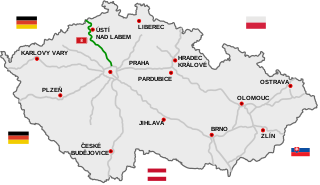
Čeština: Dálnice D8:
existující úsek
úsek ve výstavbě
plánovaný úsek
Polski: Przebieg autostrady D8:
odcinki istniejące
odcinki w budowie
odcinki projektowane
English: D8 motorway:
existing sections
sections under construction
planned sections
Deutsch: Autobahn D8:
Strecken unter Verkehr
Strecken in Bau
geplante Strecken |
| Date | |
| Source |
Own work
|
| Author | Daniel749 |
| SVG development |
Licensing
[edit]
I, the copyright holder of this work, hereby publish it under the following license:
This file is licensed under the Creative Commons Attribution 3.0 Unported license.
- You are free:
- to share – to copy, distribute and transmit the work
- to remix – to adapt the work
- Under the following conditions:
- attribution – You must give appropriate credit, provide a link to the license, and indicate if changes were made. You may do so in any reasonable manner, but not in any way that suggests the licensor endorses you or your use.
File history
Click on a date/time to view the file as it appeared at that time.
| Date/Time | Thumbnail | Dimensions | User | Comment | |
|---|---|---|---|---|---|
| current | 07:12, 13 June 2022 | | 780 × 450 (51 KB) | Lukša (talk | contribs) | removed D43 (now I/73) |
| 10:13, 14 October 2017 |  | 776 × 446 (153 KB) | Daniel749 (talk | contribs) | update | |
| 10:07, 14 October 2017 |  | 728 × 418 (147 KB) | Daniel749 (talk | contribs) | update | |
| 21:13, 17 December 2016 |  | 728 × 418 (145 KB) | Delasoto (talk | contribs) | update to date | |
| 19:35, 26 January 2016 |  | 728 × 418 (146 KB) | Daniel749 (talk | contribs) | {{Information |Description={{pl|Przebieg autostrady D8:}} {{Legend||line=7px solid #009100|odcinki istniejące}} {{Legend||line=7px solid red|odcinki w budowie}} {{Legend||line=7px dotted #444444|odcinki projektowane}} {... |
You cannot overwrite this file.
File usage on Commons
The following 11 pages use this file:
- User:Chumwa/OgreBot/Potential transport maps/2016 December 11-20
- User:Chumwa/OgreBot/Potential transport maps/2016 January 21-31
- User:Chumwa/OgreBot/Potential transport maps/2017 October 11-20
- User:Chumwa/OgreBot/Transport Maps/2016 December 11-20
- User:Chumwa/OgreBot/Transport Maps/2016 January 21-31
- User:Chumwa/OgreBot/Transport Maps/2017 October 11-20
- User:Chumwa/OgreBot/Transport Maps/2022 June 11-20
- User:Chumwa/OgreBot/Travel and communication maps/2016 December 11-20
- User:Chumwa/OgreBot/Travel and communication maps/2016 January 21-31
- User:Chumwa/OgreBot/Travel and communication maps/2017 October 11-20
- User:Chumwa/OgreBot/Travel and communication maps/2022 June 11-20
File usage on other wikis
The following other wikis use this file:
- Usage on bg.wikipedia.org
- Usage on cs.wikipedia.org
- Usage on de.wikipedia.org
- Usage on pl.wikipedia.org
- Usage on ru.wikipedia.org
- Usage on sk.wikipedia.org
- Usage on sv.wikipedia.org