File:Moses Shobe House.jpg
Original file (2,816 × 1,584 pixels, file size: 935 KB, MIME type: image/jpeg)
Captions
This is an image of a place or building that is listed on the National Register of Historic Places in the United States of America. Its reference number is 79003521. |
Camera location | 37° 04′ 55.5″ N, 86° 14′ 06.5″ W | View this and other nearby images on: OpenStreetMap | 37.082083; -86.235139 |
---|
DescriptionMoses Shobe House.jpg |
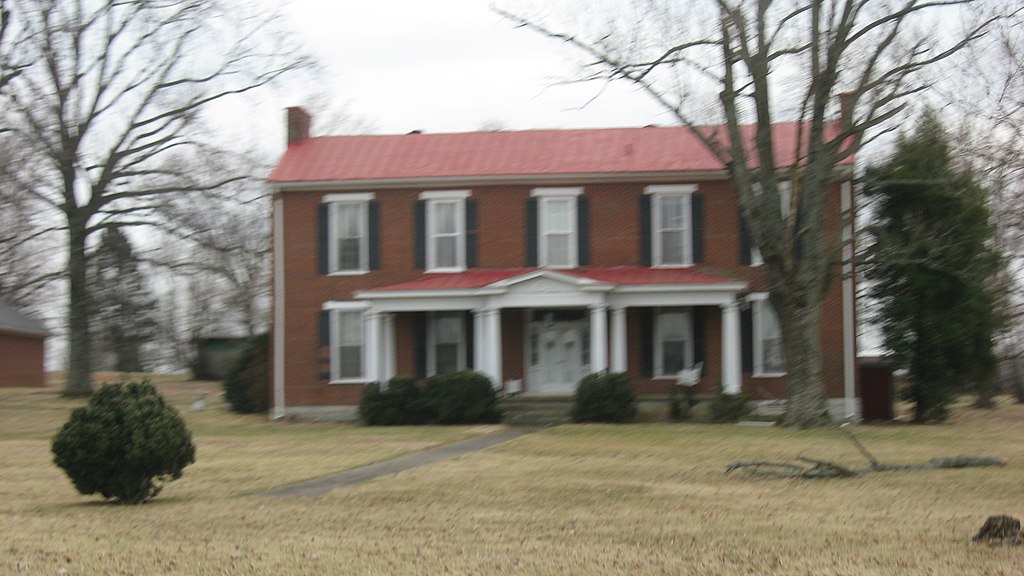
English: Front of the Moses Shobe House, located on the southern side of U.S. Route 31 north of Smiths Grove in Warren County, Kentucky, United States. Built in 1850, it is listed on the National Register of Historic Places. |
|||
Date | Taken on 1 March 2014 | |||
Source | Own work | |||
Author | Nyttend | |||
Permission (Reusing this file) |
|
File history
Click on a date/time to view the file as it appeared at that time.
Date/Time | Thumbnail | Dimensions | User | Comment | |
---|---|---|---|---|---|
current | 19:10, 17 March 2014 | 2,816 × 1,584 (935 KB) | Nyttend (talk | contribs) | {{NRHP|79003521}} {{Location|37|4|55.5|N|86|14|6.5|W}} {{Information |Description={{en|Front of the {{w|Moses Shobe House}}, located on the southern side of {{w|U.S. Route 31}} north of {{w|Smiths Grove, Kentucky|Smiths Grove}} in {{w|Warren County, Ke... |
You cannot overwrite this file.
File usage on Commons
The following page uses this file:
File usage on other wikis
The following other wikis use this file:
- Usage on en.wikipedia.org
Metadata
This file contains additional information such as Exif metadata which may have been added by the digital camera, scanner, or software program used to create or digitize it. If the file has been modified from its original state, some details such as the timestamp may not fully reflect those of the original file. The timestamp is only as accurate as the clock in the camera, and it may be completely wrong.
Camera manufacturer | Canon |
---|---|
Camera model | Canon PowerShot A540 |
Exposure time | 1/125 sec (0.008) |
F-number | f/4 |
Date and time of data generation | 15:41, 1 March 2014 |
Lens focal length | 11.759 mm |
Orientation | Normal |
Horizontal resolution | 180 dpi |
Vertical resolution | 180 dpi |
File change date and time | 15:41, 1 March 2014 |
Y and C positioning | Centered |
Exif version | 2.2 |
Date and time of digitizing | 15:41, 1 March 2014 |
Meaning of each component |
|
Image compression mode | 3 |
APEX shutter speed | 6.96875 |
APEX aperture | 4 |
APEX exposure bias | 0 |
Maximum land aperture | 3.625 APEX (f/3.51) |
Metering mode | Pattern |
Flash | Flash did not fire, auto mode, red-eye reduction mode |
Supported Flashpix version | 1 |
Color space | sRGB |
Focal plane X resolution | 12,515.555555556 |
Focal plane Y resolution | 9,372.7810650888 |
Focal plane resolution unit | inches |
Sensing method | One-chip color area sensor |
File source | Digital still camera |
Custom image processing | Normal process |
Exposure mode | Auto exposure |
White balance | Auto white balance |
Digital zoom ratio | 1 |
Scene capture type | Standard |
Structured data
Items portrayed in this file
depicts
1 March 2014
37°4'55.499"N, 86°14'6.500"W
0.008 second
11.759 millimetre
- National Register of Historic Places with known IDs
- National Register of Historic Places missing SDC depicts
- National Register of Historic Places missing SDC location of creation
- Files with coordinates missing SDC location of creation
- Photographs taken on 2014-03-01
- Self-published work
- PD-self
- Building-centered pictures by User:Nyttend