File:Moses McKay House after restoration.jpg
Jump to navigation
Jump to search

Size of this preview: 800 × 600 pixels. Other resolutions: 320 × 240 pixels | 640 × 480 pixels | 1,024 × 768 pixels | 1,280 × 960 pixels | 2,560 × 1,920 pixels | 2,816 × 2,112 pixels.
Original file (2,816 × 2,112 pixels, file size: 3.16 MB, MIME type: image/jpeg)
Captions
Captions
Add a one-line explanation of what this file represents
|
This is an image of a place or building that is listed on the National Register of Historic Places in the United States of America. Its reference number is 78002207. |
| Camera location | | View this and other nearby images on: OpenStreetMap |
|---|
| Description |
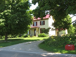
English: Front of the Moses McKay House, located at 1818 New Burlington Road east of Waynesville in Wayne Township, Warren County, Ohio, United States. Built in 1818, it is listed on the National Register of Historic Places. |
||
| Date | Taken on 30 June 2010 | ||
| Source | Own work | ||
| Author | Nyttend | ||
| Permission (Reusing this file) |
|
||
| Other versions |
 Before restoration Before restoration |
File history
Click on a date/time to view the file as it appeared at that time.
| Date/Time | Thumbnail | Dimensions | User | Comment | |
|---|---|---|---|---|---|
| current | 15:55, 1 July 2010 | | 2,816 × 2,112 (3.16 MB) | Nyttend (talk | contribs) | {{Location|39|32|37|N|84|0|57|W}} {{Information |Description={{en|Front of the {{w|Moses McKay House}}, located at 1818 New Burlington Road east of {{w|Waynesville, Ohio|Waynesville}} in {{w|Wayne Township, Warren County, Ohio|Wayne Township}}, {{w|Warren |
You cannot overwrite this file.
File usage on Commons
The following 2 pages use this file:
File usage on other wikis
The following other wikis use this file:
- Usage on en.wikipedia.org
- Usage on es.wikipedia.org
- Usage on eu.wikipedia.org
- Usage on fa.wikipedia.org
- Usage on pl.wikipedia.org
- Usage on pt.wikipedia.org
- Usage on ur.wikipedia.org
- Usage on vi.wikipedia.org
- Usage on www.wikidata.org
- Usage on zh.wikipedia.org