File:Moscow metro map de sb.svg
Jump to navigation
Jump to search

Size of this PNG preview of this SVG file: 470 × 600 pixels. Other resolutions: 188 × 240 pixels | 376 × 480 pixels | 602 × 768 pixels | 803 × 1,024 pixels | 1,605 × 2,048 pixels | 1,270 × 1,620 pixels.
Original file (SVG file, nominally 1,270 × 1,620 pixels, file size: 73 KB)
Captions
Captions
Add a one-line explanation of what this file represents
Summary
[edit]
|
This file has been superseded by Moscow metro map sb.svg|lang=en. It is recommended to use the other file. Please note that deleting superseded images requires consent.
|

|
| Description |
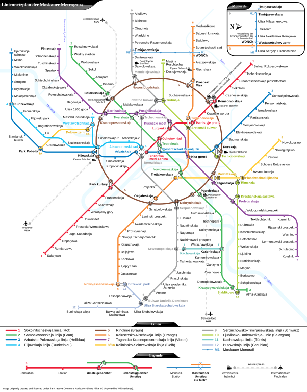
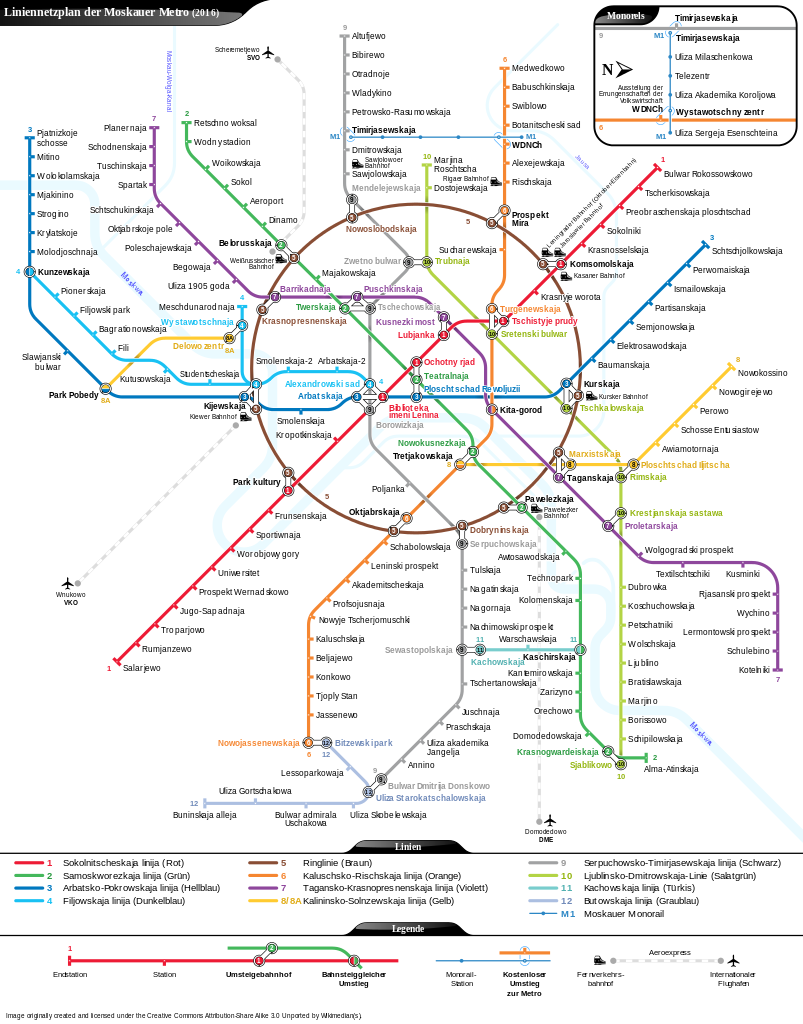
Deutsch: Liniennetzplan der Moskauer Metro (2015) |
|||
| Date | 20 October 2015, 09:28:24 (upload date) | |||
| Source | Own work | |||
| Author | Sameboat, transliterated by Kopiersperre | |||
| Permission (Reusing this file) |
I, the copyright holder of this work, hereby publish it under the following licenses:
This file is licensed under the Creative Commons Attribution-Share Alike 3.0 Unported license.
You may select the license of your choice. |
|||
| Other versions |
Zukünftige Erweiterungen:
|
|||
| SVG development | This map was created with Adobe Illustrator. |


This vector image was created with a text editor.
Please do not replace the simplified code of this file with a version created with Inkscape or any other vector graphics editor
File history
Click on a date/time to view the file as it appeared at that time.
| Date/Time | Thumbnail | Dimensions | User | Comment | |
|---|---|---|---|---|---|
| current | 04:12, 6 April 2016 | | 1,270 × 1,620 (73 KB) | Sameboat (talk | contribs) | |
| 01:28, 16 February 2016 |  | 1,270 × 1,620 (72 KB) | Sameboat (talk | contribs) | ||
| 03:54, 19 January 2016 |  | 1,270 × 1,620 (72 KB) | Sameboat (talk | contribs) | Rumyantsevo | |
| 23:44, 27 December 2015 |  | 1,270 × 1,620 (72 KB) | Sameboat (talk | contribs) | Tekhnopark | |
| 11:18, 20 October 2015 |  | 1,270 × 1,620 (72 KB) | Sameboat (talk | contribs) | Adjustments for superimposition of texts and lines | |
| 09:28, 20 October 2015 |  | 1,270 × 1,620 (71 KB) | Kopiersperre (talk | contribs) | {{Information |Description={{de|Liniennetzplan der Moskauer Metro (2015)}} |Source={{own}} |Date=as upload date |Author=Sameboat, transliterated by Kopiersperre |Permission={{self|GFDL|cc-by-sa-3.0}} |other_versi... |
You cannot overwrite this file.
File usage on Commons
The following 22 pages use this file:
- User:Chumwa/OgreBot/Potential transport maps/2016 April 1-10
- User:Chumwa/OgreBot/Potential transport maps/2016 February 10-19
- User:Chumwa/OgreBot/Potential transport maps/2016 January 11-20
- User:Chumwa/OgreBot/Public transport information/2015 December 21-31
- User:Chumwa/OgreBot/Public transport information/2015 October 11-20
- User:Chumwa/OgreBot/Public transport information/2016 April 1-10
- User:Chumwa/OgreBot/Public transport information/2016 February 10-19
- User:Chumwa/OgreBot/Public transport information/2016 January 11-20
- User:Chumwa/OgreBot/Transport Maps/2015 December 21-31
- User:Chumwa/OgreBot/Transport Maps/2015 October 11-20
- User:Chumwa/OgreBot/Transport Maps/2016 April 1-10
- User:Chumwa/OgreBot/Transport Maps/2016 February 10-19
- User:Chumwa/OgreBot/Transport Maps/2016 January 11-20
- User:Chumwa/OgreBot/Travel and communication maps/2016 April 1-10
- User:Chumwa/OgreBot/Travel and communication maps/2016 February 10-19
- User:Chumwa/OgreBot/Travel and communication maps/2016 January 11-20
- User:Sameboat
- User:Stolbovsky/Recent uploads/Moscow/2015 December 21-31
- User:Stolbovsky/Recent uploads/Moscow/2016 April 1-10
- User:Stolbovsky/Recent uploads/Moscow/2016 February 10-19
- User:Stolbovsky/Recent uploads/Moscow/2016 January 11-20
- File:Moscow metro map de sb.pdf