File:Moscow 1662 Atlas Maior.png
Original file (2,805 × 2,167 pixels, file size: 7.45 MB, MIME type: image/png)
Captions
Captions
Summary
[edit]| Description |
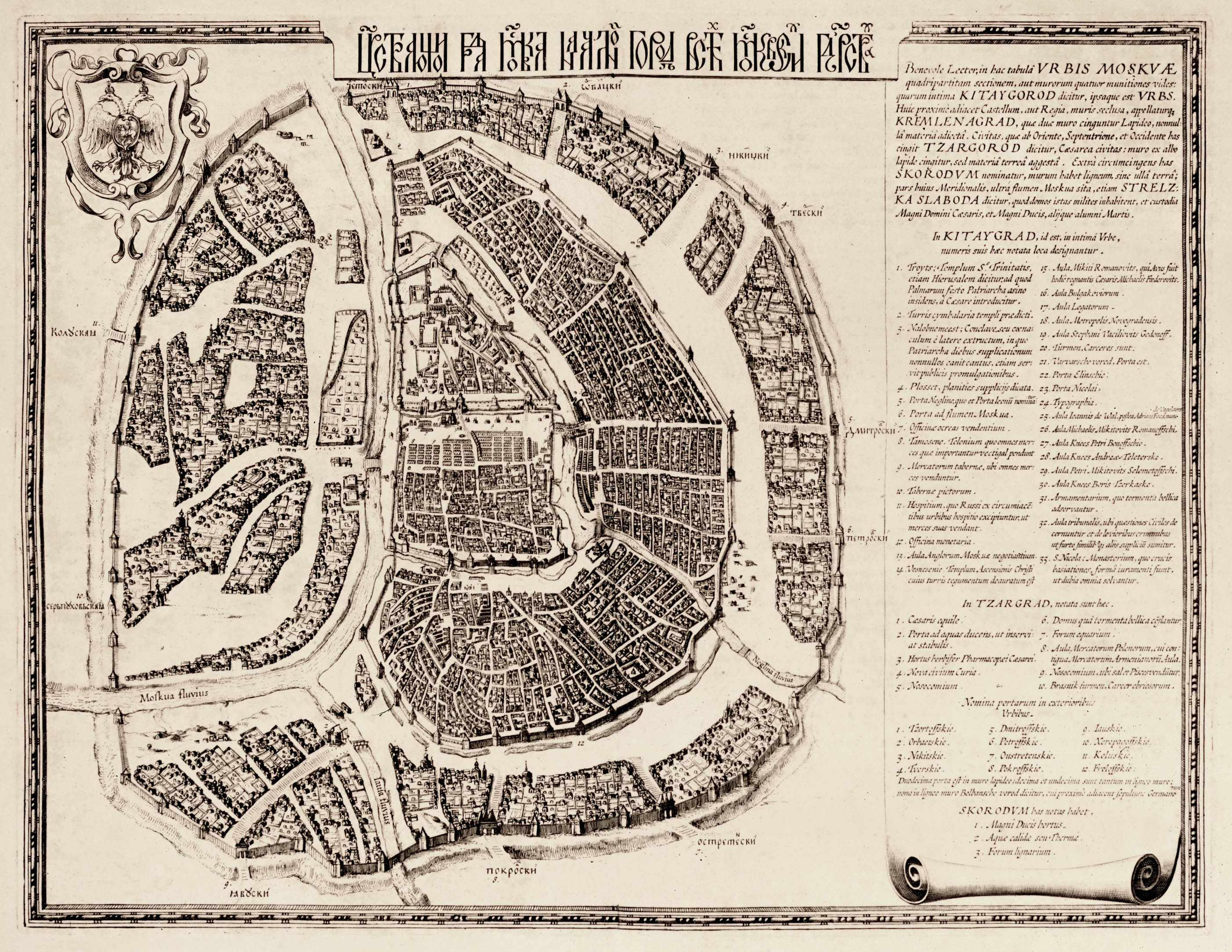
Moscow in 1597-1599. The text in the top right is a description of the city in Latin, the first part of which roughly means this: Русский: «Петров чертеж». План Москвы 1597-1599 года.
Данный план относится к одним из самых ранних. Он весьма напоминает весьма схожий с ним план Феодора Борисовича. Как и другие планы времен Годунова и после него, он примечателен тем, что выполнен в несколько непривычной для нас ориентации. С точки зрения современных картографов, его следовало бы повернуть на 90 градусов против часовой стрелки. Вокруг истории этого плана существуют разночтения. Н.М.Молева в книге «Москвы ожившие придания» относит его к периоду между 1597 и 1599 годами, а первое издание датирует 1662 годом (во втором томе «Космографии» Блавиана в Амстердаме). В книге «Архитектурные ансамбли Москвы XV - начала XX веков», изданной под редакцией Т.Ф.Саваренской, его относят к началу 1600-х годов, и считают что впервые он был издан Г.Гарритсом в 1613 году. |
||||||||||||||||||||||||||
| Date | |||||||||||||||||||||||||||
| Source | |||||||||||||||||||||||||||
| Author |
|
||||||||||||||||||||||||||
.jpg)
Licensing
[edit]
|
This is a faithful photographic reproduction of a two-dimensional, public domain work of art. The work of art itself is in the public domain for the following reason:
The official position taken by the Wikimedia Foundation is that "faithful reproductions of two-dimensional public domain works of art are public domain".
This photographic reproduction is therefore also considered to be in the public domain in the United States. In other jurisdictions, re-use of this content may be restricted; see Reuse of PD-Art photographs for details. | ||||
| Annotations | This image is annotated: View the annotations at Commons |
File history
Click on a date/time to view the file as it appeared at that time.
| Date/Time | Thumbnail | Dimensions | User | Comment | |
|---|---|---|---|---|---|
| current | 17:07, 22 November 2010 | | 2,805 × 2,167 (7.45 MB) | Malus Catulus (talk | contribs) | {{Information |Description=Moscow in 1662 |Source=*Atlas Maior *http://historic-cities.huji.ac.il/russia/moscow/maps/blaeu_latin_1662_v2.html |Date=1662 |Author=Joan Blaeu |Permission= |other_versions= }} Category:Maps of Moscow Category:1662 [[C |
You cannot overwrite this file.
File usage on Commons
There are no pages that use this file.