File:Morocco and Mauritania (MODIS 2020-12-17).jpg

Original file (2,545 × 1,924 pixels, file size: 356 KB, MIME type: image/jpeg)
Captions
Captions
Summary
[edit].jpg&action=edit§ion=1)
| Description |
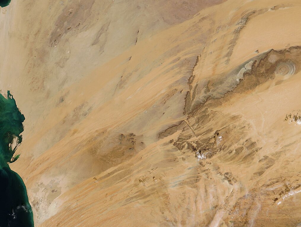
English: Soft orange and tan Saharan sands sweep across the arid lands of Mauritania and southern Morocco. The vast expanses of sand are framed by mountains and exposed rocky plateaus, all creating the image of a desert landscape, where dry climate conditions and periodic drought creates difficult living conditions. Most of the population in this region lives along the coastline of the Atlantic Ocean, where conditions are more favorable than in the interior.
The most striking inland feature is the rugged exposed rock of the Adrar Plateau, a raised central massif with cliffs that rise to roughly 800 feet (240 m). Extremely arid in the highlands, the region at the base of the plateau holds enough moisture to support date-palm groves. In some areas, crops such as millet, sorghum, melons and vegetables can be grown. One of the most recognizable features of Mauritania is the Richat Structure, an uplifted dome that appears something like a sliced onion from space, with several concentric circles made of igneous and sedimentary rock. The Richat Structure can be seen near the upper right edge of this image. The Moderate Resolution Imaging Spectroradiometer (MODIS) on board NASA’s Terra satellite acquired a true-color image centered on Mauritania on December 15, 2020. Much of the region in the northwestern edge of the image is contested land, where the boundary between Morocco (north) and Mauritania (inland and south), is in dispute. In addition, the Sahrawi Arab Democratic Republic (SADR) claims part of this area as its independent territory. The disputed area sits on the northwest coast of Africa and bordered by Morocco, Mauritania, and Algeria. It has been designated as Western Sahara, a non-self-governing territory. According to the CIA World Factbook, when Spain withdrew from its former colony of Spanish Sahara in 1976, Morocco annexed the northern two-thirds of Western Sahara and claimed the rest of the territory in 1979, following Mauritania’s withdrawal. A war with the Polisaro Front, which founded the SADR, over Morocco’s claim to sovereignty ended in a 1991 cease fire. However, a referendum on independence or integration into Morocco has never taken place, leaving the region’s ownership in question. Morocco created a long sand berm running the length of the territory, and this has become the line of demarcation between Morocco’s control in the large territory to the west and the SADR’s control east of the berm. Tensions remain high in the region, especially between native Sahrawi peoples and Moroccan immigrants. |
||
| Date | Taken on 15 December 2020 | ||
| Source |
Morocco and Mauritania (direct link)
|
||
| Author | MODIS Land Rapid Response Team, NASA GSFC |
| This media is a product of the Terra mission Credit and attribution belongs to the mission team, if not already specified in the "author" row |
Licensing
[edit].jpg&action=edit§ion=2)
| This file is in the public domain in the United States because it was solely created by NASA. NASA copyright policy states that "NASA material is not protected by copyright unless noted". (See Template:PD-USGov, NASA copyright policy page or JPL Image Use Policy.) | ||
 |
Warnings:
|
File history
Click on a date/time to view the file as it appeared at that time.
| Date/Time | Thumbnail | Dimensions | User | Comment | |
|---|---|---|---|---|---|
| current | 19:22, 2 February 2024 | | 2,545 × 1,924 (356 KB) | OptimusPrimeBot (talk | contribs) | #Spacemedia - Upload of http://modis.gsfc.nasa.gov/gallery/images/image12172020_250m.jpg via Commons:Spacemedia |
You cannot overwrite this file.
File usage on Commons
There are no pages that use this file.
.jpg&oldid=848353375)