File:Mormon Bridge historical marker.jpg

Original file (3,024 × 4,032 pixels, file size: 5.52 MB, MIME type: image/jpeg)
Captions
Captions
Summary
[edit]
| Description |
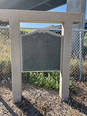
English: Historical marker located underneath the Mormon Bridge on the Nebraska side. |
| Date | |
| Source | Own work |
| Author | Declan M Martin |
| Openstreetmap entry | Link to Openstreetmap |
| Object location | | View this and other nearby images on: OpenStreetMap |
|---|
| Camera location | | View this and other nearby images on: OpenStreetMap |
|---|
Plaque :
erected June 1, 1953 Mormon pioneer Memorial Bridge
This bridge is on the Mormon Pioneer Trail from Nauvoo, Illinois to the Rocky Mountains. Driven from their homes by mobs, many of the dispossessed Mormon people crossed the Mississippi river on the ice in February, 1846. From these refugees five hundred volunteers for the Mexican war left here on the longest infantry March in recorded history.
Winter quarters was established in the West Bank of the Missouri river, and a ferry was operated at this site. Six hundred of these people – Nebraska’s first white settlers – died here that winter.
April 5, 1847, Brigham Young and one hundred forty-seven others resumed the journey to select the trail and look at the place where the Mormon people could worship god in accordance with their religious belief. They reached the valley of the great Salt Lake July 24 and founded Salt Lake City “in the top of the mountains”. Thousands followed. They instituted modern irrigation and built an empire in the west.Licensing
[edit]
| I, the copyright holder of this work, release this work into the public domain. This applies worldwide. In some countries this may not be legally possible; if so: I grant anyone the right to use this work for any purpose, without any conditions, unless such conditions are required by law. |
| ⧼If being used for commerical purposes, crediting "Declan M Martin" is appreciated but not mandatory.⧽ |
File history
Click on a date/time to view the file as it appeared at that time.
| Date/Time | Thumbnail | Dimensions | User | Comment | |
|---|---|---|---|---|---|
| current | 00:24, 10 August 2022 | | 3,024 × 4,032 (5.52 MB) | Dmartin969 (talk | contribs) | Uploaded a work by Declan M Martin from Own work with UploadWizard |
You cannot overwrite this file.
File usage on Commons
The following page uses this file:
Metadata
- Mormon Bridge (Nebraska-Iowa)
- Historical markers in Nebraska
- Plaques referencing 1846 in the United States
- Plaques referencing 1847 in the United States
- Plaques referencing 1853 in the United States
- Historical markers in Nebraska - Migration routes
- Nebraska state historical markers
- Signs in Douglas County, Nebraska
- History of Douglas County, Nebraska