File:Morenci Mine, AZ (ASTER).jpg
Jump to navigation
Jump to search

Size of this preview: 746 × 599 pixels. Other resolutions: 299 × 240 pixels | 598 × 480 pixels | 956 × 768 pixels | 1,275 × 1,024 pixels | 1,403 × 1,127 pixels.
Original file (1,403 × 1,127 pixels, file size: 400 KB, MIME type: image/jpeg)
Captions
Captions
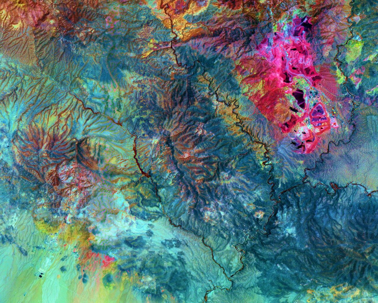
The Morenci open-pit copper mine in southeast Arizona is North America's leading producer of copper. In the 1860s, prospectors arrived looking for gold; instead they found copper.
Summary
[edit].jpg&action=edit§ion=1)
| Description |
English: The Morenci open-pit copper mine in southeast Arizona is North America's leading producer of copper. In the 1860s, prospectors arrived looking for gold; instead they found copper. Underground mining began in the 1870s, and the first pit was opened in 1939. Phelps Dodge employs over 200 people in the mining and refining operations. Around-the-clock removal of 700,000 tons of rock per day results in production of 382 thousand tons of copper per year. Phelps Dodge is now developing the Safford Mine, about 12 km southwest of Morenci. It will be the first new copper mine in the US in more than 30 years. When production starts in 2008, the Safford Mine will produce 109 thousand tons of copper. This ASTER image uses shortwavelength infrared bands to highlight in bright pink the altered rocks in the Morenci pit associated with copper mineralization. The image covers an area of 21 x 16.9 km, was acquired on July 14, 2007, and is centered near 33.1 degrees north latitude, 109.5 degrees west longitude. |
||
| Date | Taken on 14 July 2007 | ||
| Source |
Morenci Mine, AZ (direct link)
|
||
| Author | NASA/METI/AIST/Japan Space Systems, and U.S./Japan ASTER Science Team |
| Object location | | View this and other nearby images on: OpenStreetMap |
|---|
.jpg¶ms=033.100000_N_-109.500000_E_globe:Earth_class:object_type:object__&language=en)
| This media is a product of the Terra mission Credit and attribution belongs to the Advanced Spaceborne Thermal Emission and Reflection Radiometer (ASTER) team, NASA/METI/AIST/Japan Space Systems |
Licensing
[edit].jpg&action=edit§ion=2)
| This file is in the public domain in the United States because it was solely created by NASA. NASA copyright policy states that "NASA material is not protected by copyright unless noted". (See Template:PD-USGov, NASA copyright policy page or JPL Image Use Policy.) | ||
 |
Warnings:
|
File history
Click on a date/time to view the file as it appeared at that time.
| Date/Time | Thumbnail | Dimensions | User | Comment | |
|---|---|---|---|---|---|
| current | 12:08, 25 June 2023 | | 1,403 × 1,127 (400 KB) | OptimusPrimeBot (talk | contribs) | #Spacemedia - Upload of https://asterweb.jpl.nasa.gov/gallery/images/morenci.jpg via Commons:Spacemedia |
You cannot overwrite this file.
File usage on Commons
There are no pages that use this file.
.jpg&oldid=909524618)