File:Moosfluh slope instability ESA372872.jpg
Jump to navigation
Jump to search
Size of this preview: 800 × 567 pixels. Other resolutions: 320 × 227 pixels | 640 × 453 pixels | 1,024 × 726 pixels | 1,280 × 907 pixels | 2,560 × 1,814 pixels | 4,955 × 3,511 pixels.
Original file (4,955 × 3,511 pixels, file size: 4.29 MB, MIME type: image/jpeg)
Captions
Captions
Add a one-line explanation of what this file represents
Summary
[edit]
| Description |
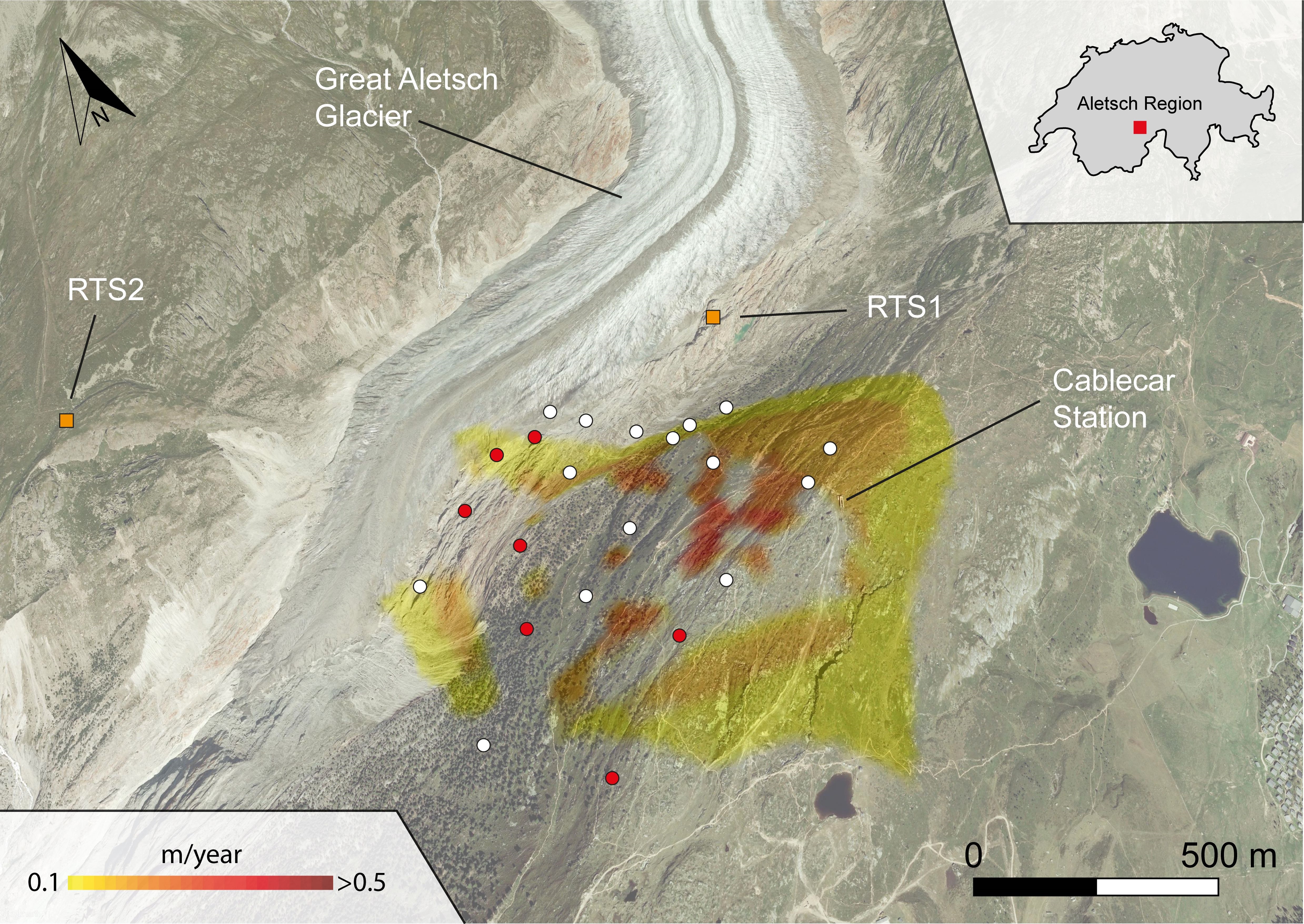
English: Land deformation speed of the Moosfluh area observed by the Sentinel-1 satellite from August to November 2016. The monitoring system installed by the Chair of Engineering Gelogy at ETHZ includes two Robotized Total Stations (RTS1 and RTS2), which monitor the evolution of surface displacements at point targets located on the unstable area (white and red dots). The results obtained from satellite data helped scientists to define the extension of the most active area and identify locations to place additional monitoring targets (red dots). |
| Date | |
| Source | http://www.esa.int/spaceinimages/Images/2016/02/Moosfluh_slope_instability |
| Author | European Space Agency |
| Permission (Reusing this file) |
Contains modified Copernicus Sentinel data (2016), processed by Geohazards-TEP,CC BY-SA 3.0 IGO |
| Title | Moosfluh slope instability |
| System | Copernicus |
| Keywords | Landslides |
| Location | The Alps |
| Mission | Sentinel-1 |
| Activity | Observing the Earth |
Licensing
[edit]
This file is licensed under the Creative Commons Attribution-ShareAlike 3.0 IGO license.
- You are free:
- to share – to copy, distribute and transmit the work
- to remix – to adapt the work
- Under the following conditions:
- attribution – You must give appropriate credit, provide a link to the license, and indicate if changes were made. You may do so in any reasonable manner, but not in any way that suggests the licensor endorses you or your use.
- share alike – If you remix, transform, or build upon the material, you must distribute your contributions under the same or compatible license as the original.
File history
Click on a date/time to view the file as it appeared at that time.
| Date/Time | Thumbnail | Dimensions | User | Comment | |
|---|---|---|---|---|---|
| current | 15:21, 6 May 2017 | | 4,955 × 3,511 (4.29 MB) | Fæ (talk | contribs) | == {{int:filedesc}} == {{information | description = {{en|1=Land deformation speed of the Moosfluh area observed by the Sentinel-1 satellite from August to November 2016. The monitoring system installed by the Chair of Engineering Gelogy at ETHZ includ... |
You cannot overwrite this file.
File usage on Commons
The following page uses this file: