File:Monuments to Captain Surgeon Arthur Martin-Leake, VC and Bar, and to Kommandant Claassen Croix de Guerre.JPG
Jump to navigation
Jump to search
Size of this preview: 800 × 533 pixels. Other resolutions: 320 × 213 pixels | 640 × 427 pixels | 1,024 × 683 pixels | 1,280 × 853 pixels | 2,560 × 1,707 pixels | 3,456 × 2,304 pixels.
Original file (3,456 × 2,304 pixels, file size: 3.79 MB, MIME type: image/jpeg)
Captions
Captions
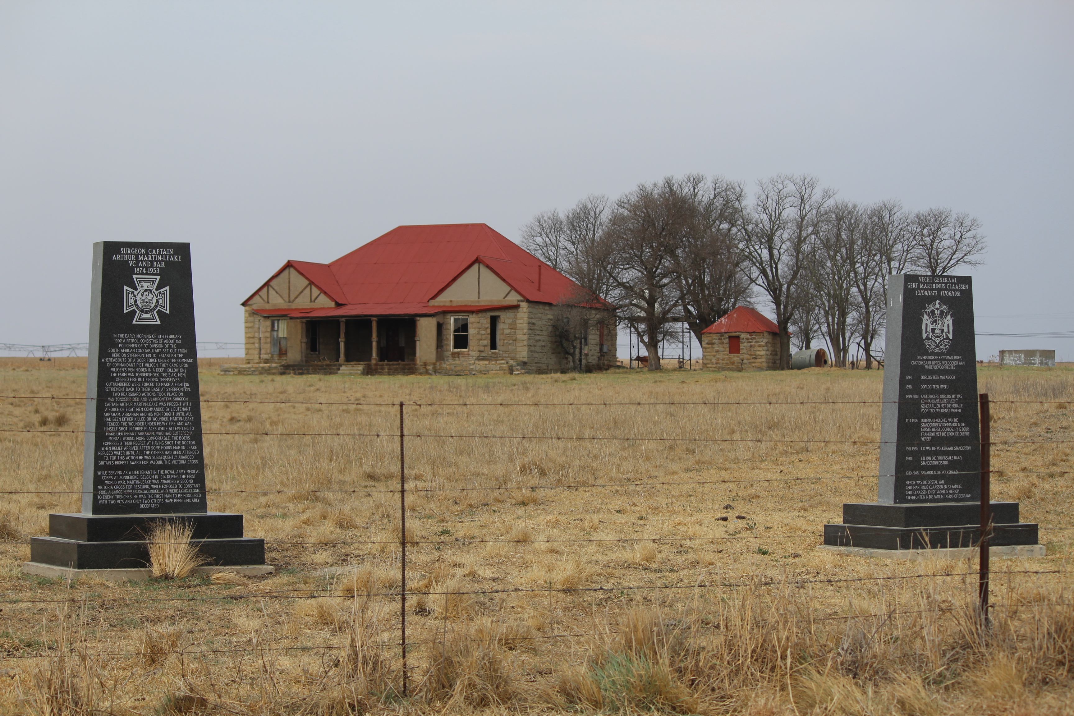
Monuments to two military people of the Second Boer War, one British and one Boer, near Val in western Mpumalanga, South Africa
Summary
[edit]
| Description |
Afrikaans: Monumente vir twee militêre tydgenote op Syferfontein, die eertydse plaas van Kommandant (later Vecht Generaal) Gert Marthinus Claassen (1872-1951) naby Val in westelike Mpumalanga. Die monumente vereer twee uitstaande indiwidue van die Tweede Vryheidsoorlog: a) Surgeon Captain Arthur Martin-Leake (1874-1953), een van min wat twee Victoriakruise kon verwerf, sy eerste by die Slag van Van Tondershoek, en die tweede tydens die Eerste Wêreldoorlog, b) Kommandant Claassen van die Standerton-kommando, wat 'n Croix de Guerre tydens die Eerste Wêreldoorlog verwerf het.
English: Monuments to two contemporary military men, erected at Syferfontein, the former farm of Commandant G. M. Claassen (1872-1951), located near Val in western Mpumalanga, South Africa. These commemorate two outstanding individuals of the Second Boer War, namely: a) Captain Surgeon Martin-Leake (1874-1953), one of only a few soldiers to receive two VC's during his lifetime, his first at the Battle of Van Tondershoek, and the second during WWl, b) Commandant Claassen of the Standerton commando, who earned a Croix de Guerre during WWl.
Surgeon Captain Arthur Martin-Leake VC & Bar (1874-1953) In the early morning of 8th February 1902 a patrol, consisting of about 150 policemen of "C" Division of the South African Constabulary, set out from here on Syferfontein to establish the whereabouts of a Boer Force under the command of Commandant Piet Viljoen. They came upon Viljoen's men hidden in a deep hollow on the farm Van Tondershoek. The S.A.C. men opened fire but finding themselves outnumbered, were forced to make a fighting retirement back to their base at Syferfontein. Two rearguard actions took place on Van Tondershoek and Vlakfontein. Surgeon Captain Arthur Martin-Leake was present with a force of eight men commanded by Lieutenant Abraham Abraham, and his men fought until all had been either killed or wounded. Martin-Leake tended the wounded under heavy fire and was himself wounded by three bullets, while attempting to make Lieutenant Abraham, who had suffered a mortal wound, more comfortable. The Boers expressed their regret at having shot the doctor. When relief arrived after some hours Martin-Leake refused water until all the others had been attended to. For this action he was subsequently awarded Britain's highest award for valour, the Victoria Cross. While serving as a Lieutenant in the Royal Army Medical Corps at Zonnebeke, Belgium, in 1914 during the First World War, Martin-Leake was awarded a second Victoria Cross for rescuing, while exposed to constant fire, a large number of wounded who were lying close to enemy trenches. He was the first man to be honoured with two VC's and only two others have been similarly decorated since. Vecht Generaal Gert Marthinus Claassen (10/09/1872-17/06/1951) EENDRACHT MAAKT MACHT Onverskrokke Krygsman, Boer, Onkreukbaar opreg, Weldoener aan Minderbevoorregtes 1894: Oorlog teen Malaboch 1898: Oorlog teen Mpefu 1899-1902: Anglo Boere Oorlog. Hy was Kommandant, later Vecht Generaal, en is met die Medalje voor Trouwe Dienst vereer. 1914-1918: Luitenant-kolonel van die Standerton "A" kommando in die Eerste Wêreldoorlog. Hy is deur Frankryk met die Croix de Guerre vereer. 1915-1924: Lid van Volksraad, Standerton 1930: Lid van die Provinsiale Raad, Standerton Distrik 1939-1948: Senator in die Volksraad Hierdie opstal was die woning van Gert Marthinus Claassen en sy familie. Gert Claassen en sy vader is hier op Syferfontein in die familie-kerkhof begrawe. |
| Date | |
| Source | Own work |
| Author | Valhotel |
| Other versions |
  |
| Camera location | | View this and other nearby images on: OpenStreetMap |
|---|
| Object location | | View this and other nearby images on: OpenStreetMap |
|---|
Licensing
[edit]
I, the copyright holder of this work, hereby publish it under the following license:
This file is licensed under the Creative Commons Attribution-Share Alike 4.0 International license.
- You are free:
- to share – to copy, distribute and transmit the work
- to remix – to adapt the work
- Under the following conditions:
- attribution – You must give appropriate credit, provide a link to the license, and indicate if changes were made. You may do so in any reasonable manner, but not in any way that suggests the licensor endorses you or your use.
- share alike – If you remix, transform, or build upon the material, you must distribute your contributions under the same or compatible license as the original.

|
This image was uploaded as part of Wiki Loves Monuments 2015.
|
 |
File history
Click on a date/time to view the file as it appeared at that time.
| Date/Time | Thumbnail | Dimensions | User | Comment | |
|---|---|---|---|---|---|
| current | 12:05, 24 September 2015 | | 3,456 × 2,304 (3.79 MB) | Valhotel (talk | contribs) | User created page with UploadWizard |
You cannot overwrite this file.
File usage on Commons
The following 2 pages use this file:
File usage on other wikis
The following other wikis use this file:
- Usage on en.wikipedia.org