File:Montserrat electoral districts.svg
Jump to navigation
Jump to search

Size of this PNG preview of this SVG file: 264 × 401 pixels. Other resolutions: 158 × 240 pixels | 316 × 480 pixels | 505 × 768 pixels | 674 × 1,024 pixels | 1,348 × 2,048 pixels.
Original file (SVG file, nominally 264 × 401 pixels, file size: 86 KB)
Captions
Captions
Add a one-line explanation of what this file represents
| Description |
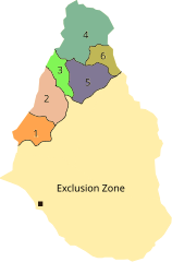
English: Location map of electoral districts in Montserrat |
||
| Date | |||
| Source | Map: Parishes of Montserrat.svg, boundaries: [1] | ||
| Author | RaviC, Carport(original) | ||
| Permission (Reusing this file) |
|
File history
Click on a date/time to view the file as it appeared at that time.
| Date/Time | Thumbnail | Dimensions | User | Comment | |
|---|---|---|---|---|---|
| current | 13:43, 23 February 2021 | | 264 × 401 (86 KB) | Grawiton (talk | contribs) | File uploaded using svgtranslate tool (https://svgtranslate.toolforge.org/). Added translation for pl. |
| 17:43, 17 May 2017 |  | 264 × 401 (85 KB) | RaviC (talk | contribs) | {{Information |Description= {{en|Location map of electoral districts in {{w|Montserrat}} }} |Source=Map: Parishes of Montserrat.svg, boundaries: [http://www.caribbeanelections.com/ms/election2014/districts/default.asp] |Date=2017-05-17 |Author=[[User:R... |
You cannot overwrite this file.
File usage on Commons
The following 2 pages use this file:
File usage on other wikis
The following other wikis use this file:
- Usage on en.wikipedia.org
- Usage on fa.wikipedia.org
- Usage on pl.wikipedia.org