File:Montenegro1913 sr.png
Jump to navigation
Jump to search

Size of this preview: 578 × 600 pixels. Other resolutions: 231 × 240 pixels | 463 × 480 pixels | 824 × 855 pixels.
Original file (824 × 855 pixels, file size: 63 KB, MIME type: image/png)
Captions
Captions
Add a one-line explanation of what this file represents
Summary
[edit]
| Description |
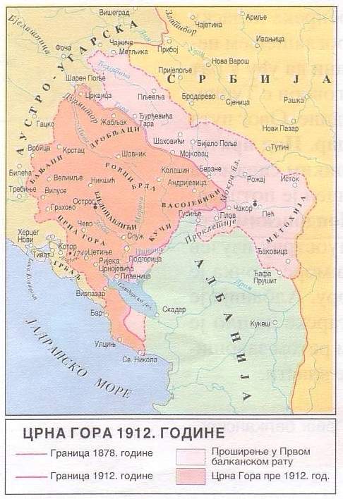
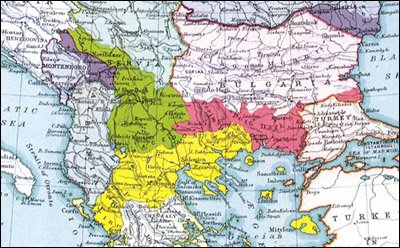
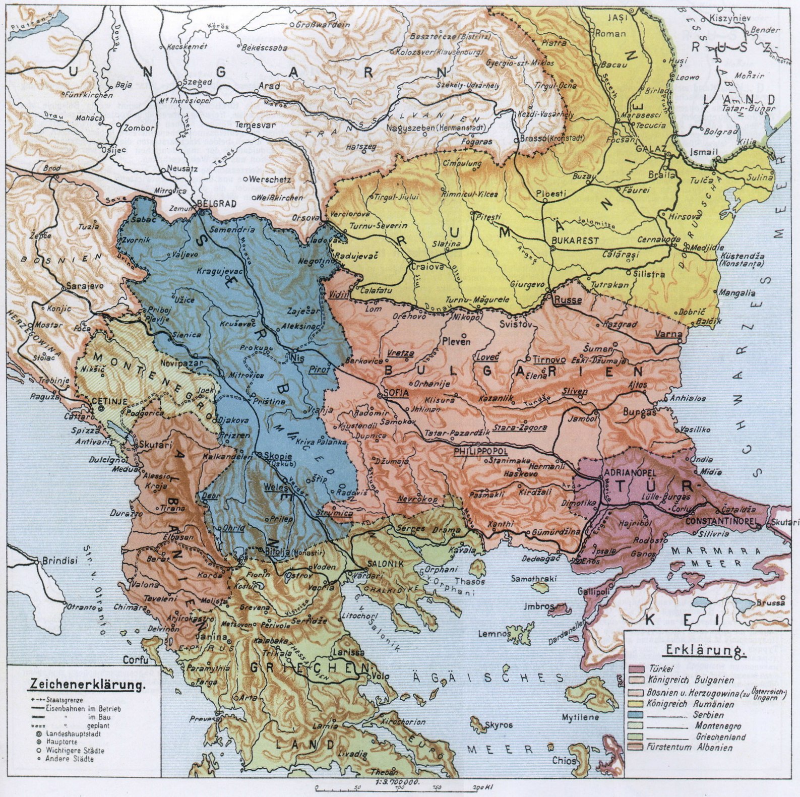
English: Kingdom of Montenegro in 1913 (Serbian / Montenegrin language version).
Српски / srpski: Краљевина Црна Гора 1913. године (верзија на српском / црногорском језику). |
| Date | |
| Source | Own work |
| Author | PANONIAN |
Licensing
[edit]
I, the copyright holder of this work, hereby publish it under the following license:
| This file is made available under the Creative Commons CC0 1.0 Universal Public Domain Dedication. | |
| The person who associated a work with this deed has dedicated the work to the public domain by waiving all of their rights to the work worldwide under copyright law, including all related and neighboring rights, to the extent allowed by law. You can copy, modify, distribute and perform the work, even for commercial purposes, all without asking permission.
|
References
[edit]
- http://terkepek.adatbank.transindex.ro/kepek/netre/330.gif
- http://terkepek.adatbank.transindex.ro/kepek/netre/106.gif
- http://anamnesis.info/resources/Crna_Gora1912.jpg
- http://www.njegos.org/markus/56.jpg
- http://www.nzhistory.net.nz/files/styles/fullsize/public/images/montenegro-map-500.jpg
- http://www.velika.me/files/Image/prilozi/mapa%201913.jpg
- http://www.montenet.org/history/mapaxvi.gif
- http://www.zum.de/whkmla/histatlas/balkans/mnegro1914.gif
- http://www.atlas-historique.net/cartographie/1815-1914/petit_format/MontenegroExpansionPF.gif
- http://www.njegos.org/markus/63.jpg
- http://2.bp.blogspot.com/-9jsDqpqPbpI/TZow2H7inOI/AAAAAAAAAp4/JajsXeZXek4/s1600/Balkan%2BPeninsula%2B1912%2B1913.bmp
- http://makedonija.name/images/history/twentieth_century/division_1913b.jpg
- http://www.promacedonia.org/en/dr/dr_map_39.jpg
- http://www.ebritic.com/wp-content/uploads/2011/01/KSHS1918.png
- The Times History of Europe, Times Books, London, 2002.
- Richard Overy, The Times History of the 20th Century, Times Books, London, 2004.
- Noel Malcolm, Kosovo - A Short History, Pan Books, London, 2002.
- Istorijski atlas, Geokarta, Beograd, 1999.
- Denis Šehić - Demir Šehić, Istorijski atlas Sveta, Beograd, 2007.
- Školski istorijski atlas, Zavod za izdavanje udžbenika SR Srbije, Beograd, 1970.
- Sve srpske mape - od šestog veka do Pariza, Specijalno izdanje BLICA, Decembar 1995. godine.
- Dr Tomislav Bogavac, Nestajanje Srba, Niš, 1994.
File history
Click on a date/time to view the file as it appeared at that time.
| Date/Time | Thumbnail | Dimensions | User | Comment | |
|---|---|---|---|---|---|
| current | 12:54, 31 August 2012 | | 824 × 855 (63 KB) | WikiEditor2004 (talk | contribs) | {{Information |Description=Kingdom of Montenegro in 1913 (Serbian language version).<br>Краљевина Црна Гора 1913. године (верзија на српском језику). |Source={{own}} |Date=2012 |Author= [[User:PANONIAN|PANON... |
You cannot overwrite this file.
File usage on Commons
There are no pages that use this file.
File usage on other wikis
The following other wikis use this file:
- Usage on bs.wikipedia.org
- Usage on mk.wikipedia.org
- Usage on pt.wikipedia.org
- Usage on sr.wikipedia.org