File:Montalba-le-Château depuis Puig Pedrós.jpg
Jump to navigation
Jump to search

Size of this preview: 800 × 600 pixels. Other resolutions: 320 × 240 pixels | 640 × 480 pixels | 1,024 × 768 pixels | 1,280 × 960 pixels | 2,560 × 1,920 pixels | 4,608 × 3,456 pixels.
Original file (4,608 × 3,456 pixels, file size: 7.08 MB, MIME type: image/jpeg)
Captions
Captions
Add a one-line explanation of what this file represents
Summary
[edit]
| Description |
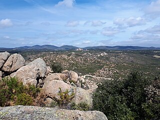
Français : La plus grande partie de la commune repose sur un plateau granitique de date hercynienne (environ 300 millions d'années), comme on peut le voir ici depuis le Puig Pedrós (alt. 435 m). Ce sommet se trouve dans le coin sud de la commune. La limite nord de la commune s'étend jusqu'à la crête des collines au-delà du village, et ces collines reposent sur des marnes noires du Crétacé (environ 100 millions d'années). La jonction entre le plateau granitique et les collines crétacées est définie par la faille nord-pyrénéenne, qui s'étend d'ouest en est, et qui est l'une des failles principales de la chaîne des Pyrénées. |
| Date | |
| Source | Own work |
| Author | Alan Mattingly |
| Camera location | | View this and other nearby images on: OpenStreetMap |
|---|
Licensing
[edit]
I, the copyright holder of this work, hereby publish it under the following license:
This file is licensed under the Creative Commons Attribution-Share Alike 4.0 International license.
- You are free:
- to share – to copy, distribute and transmit the work
- to remix – to adapt the work
- Under the following conditions:
- attribution – You must give appropriate credit, provide a link to the license, and indicate if changes were made. You may do so in any reasonable manner, but not in any way that suggests the licensor endorses you or your use.
- share alike – If you remix, transform, or build upon the material, you must distribute your contributions under the same or compatible license as the original.
File history
Click on a date/time to view the file as it appeared at that time.
| Date/Time | Thumbnail | Dimensions | User | Comment | |
|---|---|---|---|---|---|
| current | 10:14, 28 April 2023 | | 4,608 × 3,456 (7.08 MB) | Alan Mattingly (talk | contribs) | sharper image |
| 17:59, 2 January 2022 |  | 2,492 × 1,587 (949 KB) | Alan Mattingly (talk | contribs) | Uploaded own work with UploadWizard |
You cannot overwrite this file.
File usage on Commons
There are no pages that use this file.
File usage on other wikis
The following other wikis use this file:
- Usage on fr.wikipedia.org
Metadata
Categories:
- Montalba-le-Château
- Geology of Pyrénées-Orientales
- Granite formations in Pyrénées-Orientales
- Marl formations in Pyrénées-Orientales
- Paleozoic igneous intrusions in France
- Paleozoic formations in Pyrénées-Orientales
- Cretaceous formations in Pyrénées-Orientales
- Faults in Pyrénées-Orientales
- Granite in Pyrénées-Orientales
- Black marl in France