File:Mono Lake South Tufa Area (2013) 14.JPG
Jump to navigation
Jump to search
Size of this preview: 800 × 532 pixels. Other resolutions: 320 × 213 pixels | 640 × 426 pixels | 1,024 × 681 pixels | 1,280 × 851 pixels | 2,560 × 1,702 pixels | 4,512 × 3,000 pixels.
Original file (4,512 × 3,000 pixels, file size: 7.72 MB, MIME type: image/jpeg)
Captions
Captions
Add a one-line explanation of what this file represents
Summary
[edit]| Description |
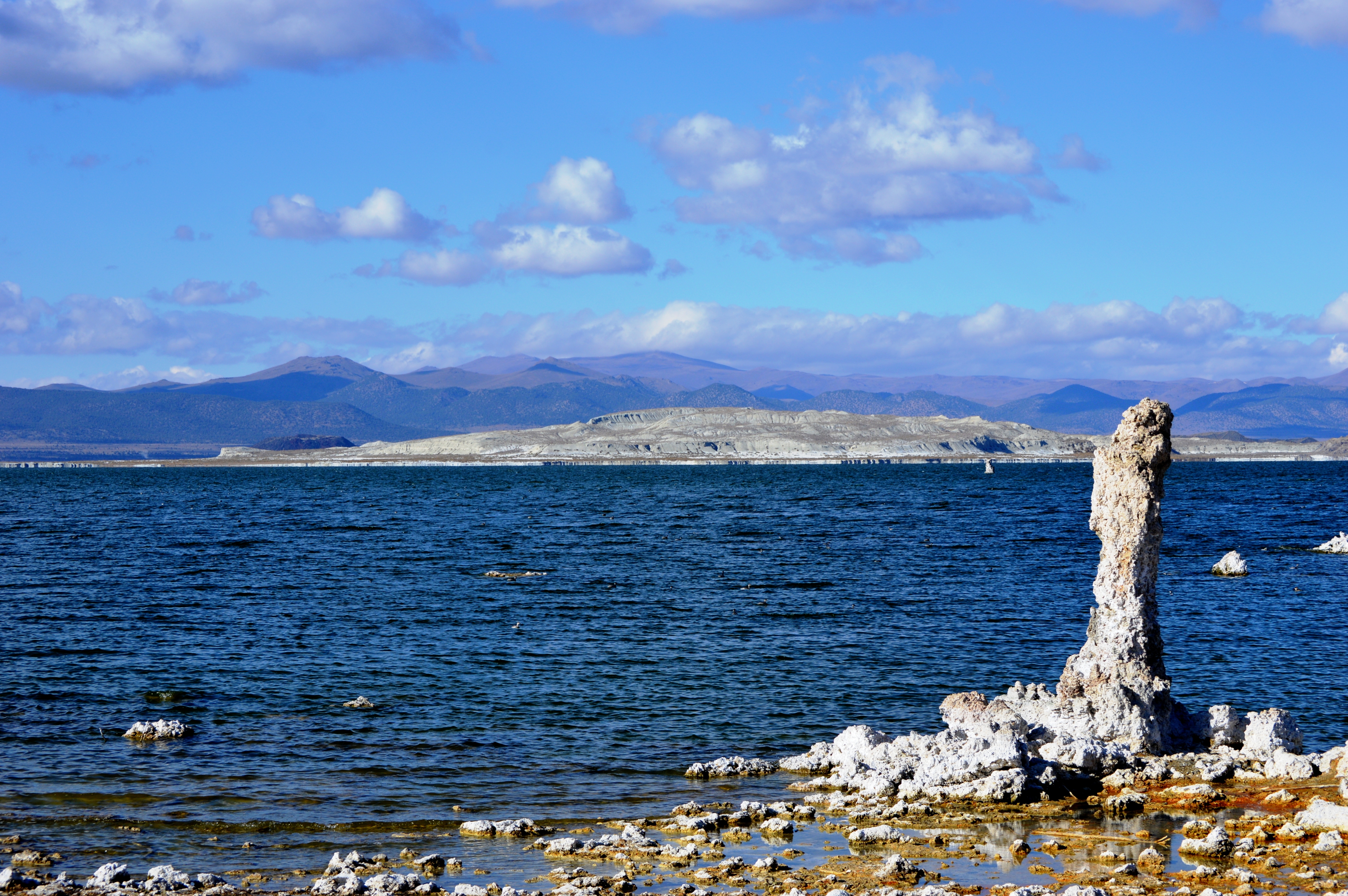
English: Mono Lake as seen from the "South Tufa" area. In the foreground (on right) is one of numerous tufa towers that are in and around the lake. Tufa can only be formed under water, but it has been exposed above water in recent decades, after Los Angeles started diverting water from the creeks that fed into the lake; see California Water Wars for details. The white formation that dominates the middle of the photo is Paoha Island, with Negit Island (smaller, black island) behind it. The low black hill on the other shore (behind Negit Island) is Black Point. On Mapcarta's satellite map, the South Tufa area itself is not marked, but it is located directly below the Paoha Island marker, to the left of the Navy Beach marker. If you zoom in, you can see the parking lot. Note that the road that connects the 120 to the South Tufa parking lot is not paved.
日本語: 「南トゥファ」区域から見るモノ湖。手前右側は湖中および岸辺に数多く立ち並ぶトゥファ(石灰華)・タワーの1つ。トゥファは水中でのみ生成される。1941年よりロサンゼルスがモノ湖の上流から水を引くようになったために湖水の蒸発量が流入量を上回って湖面が低下し、トゥファが露出されることになった(詳細は California Water Wars を参照)。白い大きな島はパオハ島で、その後(左側)の小さい黒い島はネジット島(ネッジト、ネジトとも表記される)。向こう岸の黒く低い丘はブラックポイント。Mapcarta の衛星地図では南トゥファ区域そのものには印が付いていないが、「Paoha Island」マーカーの真下、「Navy Beach」マーカーのすぐ左側にあり、ズームインすると駐車場が見える。なお、120号線から駐車場に行くまでの道は舗装されていない。 |
| Date | |
| Source | Own work |
| Author | Nandaro |
| Other versions |
|
_03.JPG)
_05.JPG)
_06.JPG)
_07.JPG)
_08.JPG)
_09.JPG)
_10.JPG)
_11.JPG)
_12.JPG)
_13.JPG)
_15.JPG)
_16.JPG)
_17.JPG)
_18.JPG)
_19.JPG)
_20.JPG)
_21.JPG)
_22.JPG)
_23.JPG)
_24.JPG)
_25.JPG)
_26.JPG)
_27.JPG)
_28.JPG)
_29.JPG)
_30.JPG)
_31.JPG)
_32.JPG)
_33.JPG)
_34.JPG)
_35.JPG)
_36.JPG)
_37.JPG)
_38.JPG)
_39.JPG)
_40.JPG)
_41.JPG)
_42.JPG)
_43.JPG)
_44.JPG)
_45.JPG)
_14.JPG&action=edit§ion=1)
Licensing
[edit]_14.JPG&action=edit§ion=2)
I, the copyright holder of this work, hereby publish it under the following license:
This file is licensed under the Creative Commons Attribution-Share Alike 3.0 Unported license.
- You are free:
- to share – to copy, distribute and transmit the work
- to remix – to adapt the work
- Under the following conditions:
- attribution – You must give appropriate credit, provide a link to the license, and indicate if changes were made. You may do so in any reasonable manner, but not in any way that suggests the licensor endorses you or your use.
- share alike – If you remix, transform, or build upon the material, you must distribute your contributions under the same or compatible license as the original.
File history
Click on a date/time to view the file as it appeared at that time.
| Date/Time | Thumbnail | Dimensions | User | Comment | |
|---|---|---|---|---|---|
| current | 22:16, 15 January 2014 | | 4,512 × 3,000 (7.72 MB) | Nandaro (talk | contribs) | User created page with UploadWizard |
You cannot overwrite this file.
File usage on Commons
The following 44 pages use this file:
- File:Mono Lake South Tufa Area (2013) 01.JPG
- File:Mono Lake South Tufa Area (2013) 02.JPG
- File:Mono Lake South Tufa Area (2013) 03.JPG
- File:Mono Lake South Tufa Area (2013) 04.JPG
- File:Mono Lake South Tufa Area (2013) 05.JPG
- File:Mono Lake South Tufa Area (2013) 06.JPG
- File:Mono Lake South Tufa Area (2013) 07.JPG
- File:Mono Lake South Tufa Area (2013) 08.JPG
- File:Mono Lake South Tufa Area (2013) 09.JPG
- File:Mono Lake South Tufa Area (2013) 10.JPG
- File:Mono Lake South Tufa Area (2013) 11.JPG
- File:Mono Lake South Tufa Area (2013) 12.JPG
- File:Mono Lake South Tufa Area (2013) 13.JPG
- File:Mono Lake South Tufa Area (2013) 15.JPG
- File:Mono Lake South Tufa Area (2013) 16.JPG
- File:Mono Lake South Tufa Area (2013) 17.JPG
- File:Mono Lake South Tufa Area (2013) 18.JPG
- File:Mono Lake South Tufa Area (2013) 19.JPG
- File:Mono Lake South Tufa Area (2013) 20.JPG
- File:Mono Lake South Tufa Area (2013) 21.JPG
- File:Mono Lake South Tufa Area (2013) 22.JPG
- File:Mono Lake South Tufa Area (2013) 23.JPG
- File:Mono Lake South Tufa Area (2013) 24.JPG
- File:Mono Lake South Tufa Area (2013) 25.JPG
- File:Mono Lake South Tufa Area (2013) 26.JPG
- File:Mono Lake South Tufa Area (2013) 27.JPG
- File:Mono Lake South Tufa Area (2013) 28.JPG
- File:Mono Lake South Tufa Area (2013) 29.JPG
- File:Mono Lake South Tufa Area (2013) 30.JPG
- File:Mono Lake South Tufa Area (2013) 31.JPG
- File:Mono Lake South Tufa Area (2013) 32.JPG
- File:Mono Lake South Tufa Area (2013) 33.JPG
- File:Mono Lake South Tufa Area (2013) 34.JPG
- File:Mono Lake South Tufa Area (2013) 35.JPG
- File:Mono Lake South Tufa Area (2013) 36.JPG
- File:Mono Lake South Tufa Area (2013) 37.JPG
- File:Mono Lake South Tufa Area (2013) 38.JPG
- File:Mono Lake South Tufa Area (2013) 39.JPG
- File:Mono Lake South Tufa Area (2013) 40.JPG
- File:Mono Lake South Tufa Area (2013) 41.JPG
- File:Mono Lake South Tufa Area (2013) 42.JPG
- File:Mono Lake South Tufa Area (2013) 43.JPG
- File:Mono Lake South Tufa Area (2013) 44.JPG
- File:Mono Lake South Tufa Area (2013) 45.JPG
_01.JPG)
_02.JPG)
_04.JPG)
File usage on other wikis
The following other wikis use this file:
- Usage on ja.wikipedia.org
_14.JPG&oldid=903865248)