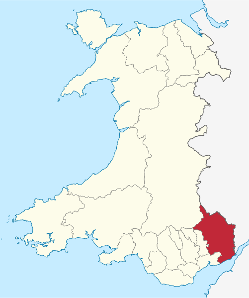
File:Monmouthshire in Wales.svg
From Wikimedia Commons, the free media repository
Jump to navigation
Jump to search

Size of this PNG preview of this SVG file: 501 × 599 pixels. Other resolutions: 201 × 240 pixels | 401 × 480 pixels | 642 × 768 pixels | 856 × 1,024 pixels | 1,713 × 2,048 pixels | 1,047 × 1,252 pixels.
Original file (SVG file, nominally 1,047 × 1,252 pixels, file size: 395 KB)
File information
Structured data
Captions
Captions
Add a one-line explanation of what this file represents
Summary
[edit]Licensing
[edit]I, the copyright holder of this work, hereby publish it under the following license:
This file is licensed under the Creative Commons Attribution-Share Alike 3.0 Unported license.
- You are free:
- to share – to copy, distribute and transmit the work
- to remix – to adapt the work
- Under the following conditions:
- attribution – You must give appropriate credit, provide a link to the license, and indicate if changes were made. You may do so in any reasonable manner, but not in any way that suggests the licensor endorses you or your use.
- share alike – If you remix, transform, or build upon the material, you must distribute your contributions under the same or compatible license as the original.

|
I'd greatly appreciate, that you attribute this media file to Wikimedia Commons, if used outside Wikipedia or Commons. For use in publications such as books, newspapers, blogs, websites, please insert here the following line:
বাংলা ∙ Deutsch ∙ Deutsch (Sie-Form) ∙ Ελληνικά ∙ English ∙ español ∙ français ∙ Ἀρχαία ἑλληνικὴ ∙ Bahasa Indonesia ∙ 日本語 ∙ македонски ∙ Nederlands ∙ português ∙ русский ∙ Türkçe ∙ 简体中文 ∙ 繁體中文 ∙ +/− |
File history
Click on a date/time to view the file as it appeared at that time.
| Date/Time | Thumbnail | Dimensions | User | Comment | |
|---|---|---|---|---|---|
| current | 13:14, 8 September 2011 |  | 1,047 × 1,252 (395 KB) | TUBS (talk | contribs) |
You cannot overwrite this file.
File usage on Commons
The following 18 pages use this file:
- Commons:Files used on the AARoads Wiki/79
- Category:Archaeological sites in Monmouthshire
- Category:Bridges in Monmouthshire
- Category:Buildings in Monmouthshire
- Category:Castles in Monmouthshire
- Category:Deaths in Monmouthshire
- Category:Education in Monmouthshire
- Category:History of Monmouthshire
- Category:Maps of Monmouthshire
- Category:Monmouthshire
- Category:People of Monmouthshire
- Category:Populated places in Monmouthshire
- Category:Rail transport in Monmouthshire
- Category:Rivers of Monmouthshire
- Category:Roads in Monmouthshire
- Category:Towns in Monmouthshire
- Category:Views of Monmouthshire
- Category:Villages in Monmouthshire
File usage on other wikis
The following other wikis use this file:
- Usage on be.wikipedia.org
- Usage on ca.wikipedia.org
- Usage on de.wikipedia.org
- Usage on et.wikipedia.org
- Usage on eu.wikipedia.org
- Usage on fi.wikipedia.org
- Usage on frr.wikipedia.org
- Usage on fr.wikipedia.org
- Abergavenny
- Monmouthshire
- Monmouth (Royaume-Uni)
- Utilisateur:Ælfgar/Brouillon6
- Chepstow
- Raglan (Monmouthshire)
- Trellech
- Gwent (comté préservé)
- Modèle:Palette Monmouthshire
- Rockfield (Monmouthshire)
- Llangattock Vibon Avel
- Caldicot
- Llangybi (Monmouthshire)
- Usk (pays de Galles)
- Tintern
- Llanover
- Caerwent
- Trellech United
- Shirenewton
- St Arvans
- Rogiet
- Portskewett
- Mitchel Troy
- Mathern
- Magor with Undy
- Llanhennock
- Llangwm (Monmouthshire)
- Llanfoist Fawr
- Llanelly
- Llanbadoc
- Llanarth (Monmouthshire)
- Gwehelog Fawr
- Grosmont
- Goetre Fawr
- Devauden
- Crucorney
- Llantrisant Fawr
- Llantilio Pertholey
- Llantilio Crossenny
- Llandogo
- Zone principale (pays de Galles)
- Wonastow
- Skenfrith
View more global usage of this file.


