File:Moll - A new and correct map of the whole World.png
Original file (2,023 × 1,200 pixels, file size: 5.32 MB, MIME type: image/png)
Captions
Summary
[edit]DescriptionMoll - A new and correct map of the whole World.png |
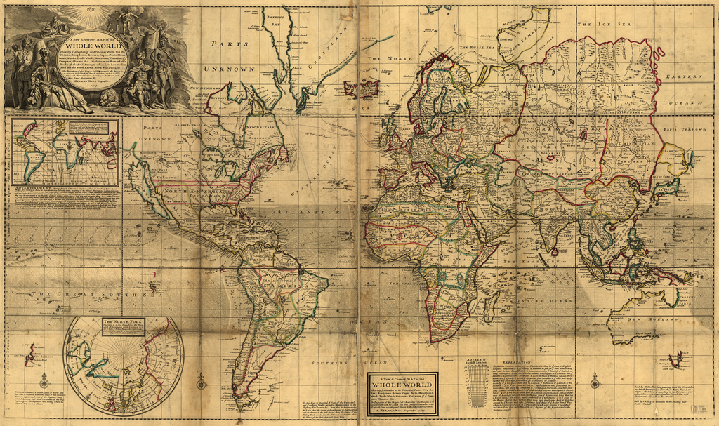
English: Title: A New and Correct Map of the Whole World: Shewing ye Situation of its Principal Parts, Viz the Oceans, Kingdoms, Rivers, Capes, Ports, Mountains, Woods, Trade Winds, Monsoons, Variation of ye Compass, Climats, &c. with the most Remarkable Tracks of the Bold Attempts which have been made to Find out the North East & North West Passages. The Projection of this Map is Call'd Mercator's the Design is to make it Useful both for Land and Sea. And it is laid Down with all possible Care, According to the Newest and Most Exact Observations By Herman Moll Geographer. 1719. |
|||||||||||||||||||||||
Date | ||||||||||||||||||||||||
Source | Unprovided | |||||||||||||||||||||||
Author |
creator QS:P170,Q1610319 |
|||||||||||||||||||||||
Other versions | See categories below. There are multiple other versions of much greater quality available. |
Licensing
[edit]Public domainPublic domainfalsefalse |
This work is in the public domain in its country of origin and other countries and areas where the copyright term is the author's life plus 100 years or fewer. You must also include a United States public domain tag to indicate why this work is in the public domain in the United States. | |
This file has been identified as being free of known restrictions under copyright law, including all related and neighboring rights. |
https://creativecommons.org/publicdomain/mark/1.0/PDMCreative Commons Public Domain Mark 1.0falsefalse
Annotations InfoField | This image is annotated: View the annotations at Commons |
LAND OF IESSO
Straits of the Vries
Companys Land
Iapon
NEW HOLLAND
Dimens Land
A New and Correct MAP of the
WHOLE WORLD
Shewing ye Situation of its Principal Parts. Viz the
Oceans, Kingdoms, Rivers, Capes, Ports, Moun:
tains, Woods, Trade Winds, Monsoons, Variation of ye
Compass, Climats, &c. With the most Remarkable
Tracks of the Bold Attempts which have been made to
Find out the North East & North West Passages.
The Projection of this Map is Call'd Mercator's the Design is
to make it Useful both for Land and Sea. And it is laid
Down with all possible Care, According to the Newest and
Most Exact Observations By
HERMAN MOLL Geographer.
1719.
A New and Correct MAP of the
WHOLE WORLD
Shewing ye Situation of its Principal Parts. Viz the
Seas, Kingdoms, Rivers, Capes, Ports, Mountains,
Woods, Trade-Winds, Monsoons, Variation of ye Com:
pass, Climats, &c.
The Projection of this Map is Call'd Mercator's the Design is to
make it Useful both for Land and Sea. And it is laid Down with
all possible Care, according to the Newest and Most Exact observations
By HERMAN MOLL Geographer. 1719.
Note. A Climate is a certain space of Earth and
Sea, that is included within the Space of two Parallels;
there are 24 on each side of the Equator, being
Limited by every half Hour's Increase of the Day;
beginning at the Equator, and ending where the
longest Day is 24 Hours.
ADVERTISEMENT. Having finish'd a New and Compleat Atlas or Set of 27 Two-sheet
Maps, and omitted no Pains to have them very correctly done, according to the Newest Observations and latest Discove:
ries, which are well known to have been very many within the compass of a few Years, I hope Noblemen, Gentlemen, and others,
will not suffer themselves to be imposed upon by old, incorrect and falsly projected Maps, under what denomination soever
they may be represented to the Publick, without taking a little Care to Look into and examine them. It is within ye Memory
of many living, that Moses Pitts Bookseller undertook to publish a New English Atlas, his Proposals were very plau:
sible, and Patrons of great Note, who were to inspect and give their Assistance, nam'd therein, among whom was
Prince Rupert, by whose Direction I drew several New Draughts for that work, but notwithstanding the vast
Incouragement Pitts had by the subscriptions of Persons of Quality and others; he had so litle Regard to do 'em
Iustice, according to his Proposals, that he purchased an Impression of Old and Incorrect Maps for his Preten:
ded New Atlas, adding only a few poorly perform'd Plates to it, which I hope will be a sufficient Caution to
every body, not to take any thing of this kind for the future upon Trust and unexamined.
This CHART is to show ye Degrees of the
Variation of ye Compass as they were Observ'd
in ye Year 1700 in ye Atlantick and Indian
Ocean; and you will see in ye Map ye Varia:
tions of ye Compass markt over ye Great South
Sea, as they were found in 179/10.
The letter A. in this Draught is the Place
which all Adventurers aimed to come at in or:
der to make ye N. West Passage, & California to ye
South Sea &c. and B. is that for ye N. East Pas:
sage - - - Iapon to the East Indies &c
In this Map is inserted A View of the General
and Coasting Trade-winds, Monsoons or the
Shifting Trade-winds. Note that the Arrows among
the Lines shew the Course of those General & Coasting winds
and the Arrows in the void Spaces shew the Course of the
Shifting Trade-winds, and the Abbreviations Sept &c. shew
the Times of the Year when such winds Blow.
To find the Distance between any two Places in this Map by ye Scale of English
Leagues, fitted from 20 to 55 Degrees of Latitude as you see ye lines numbred up
each side, the lines that go from top to bottom, intersecting ye Parallels of Latitude at
every 10 Leagues; so that each Parallel contains 100 Leagues in ye Latitude that ye
Parallel is numbred with. Example. I desire to know ye Distance between Ports:
mouth and ye Lizard; I extend ye Compasses from one place to ye other and apply:
ing that to ye Scale upon ye Parallel of 50, I find it is 60 Leagues.
Secondly, if ye two places differ only in Latitude ye Difference of Latitude is the
Distance. 3. If ye two places are both in ye same Latitude take ye Distance be:
tween them, and apply the Compasses to ye Graduated Meridian, one foot stan:
ding as much above ye Latitude as ye other below ye Degrees intresepted is the Dis:
tance. 4. If ye two places differ both in Latitude and Longitude, take ye Differ:
ence of Latitude between them in Degrees from ye Equinoctial Line then lay
a Ruler upon ye two Places, apply one Point of ye Compasses so to ye Edge of
the Ruler, that ye other turned about may just touch some East or West line
crossed by ye Ruler, then take ye Distance by ye Edge of ye Ruler from ye Place
where ye Compasses rested, by ye Place where ye Ruler crosses ye said East
and West Line that space Measured on ye Degrees of the Equinoctial is the
Distance sought.
A SCALES of
English Leagues.
Sold by H:Moll where you may have his New Atlas
or Set of Twenty-seven Two-sheet Maps, bound or
single, all Colour'd according to his Direction, over
against Devereux-Court, between Temple Bar and
St Clement's Church, in the Strand.
Sold by I.King at the Globe in the Poultrey near
Stocks Market
Printed for John Bowles at the Black Horse in Cornhill and
Tho. Bowles in St Pauls Church Yard.
File history
Click on a date/time to view the file as it appeared at that time.
Date/Time | Thumbnail | Dimensions | User | Comment | |
---|---|---|---|---|---|
current | 12:03, 21 September 2005 | 2,023 × 1,200 (5.32 MB) | Frank Schulenburg (talk | contribs) | Herman Moll: ''A new & correct map of the whole World'', London 1719 {{Creator:Herman Moll}} Category:18th century maps |
You cannot overwrite this file.
File usage on Commons
The following page uses this file: