File:Mojave & Sonoran.png
Jump to navigation
Jump to search

Size of this preview: 397 × 599 pixels. Other resolutions: 159 × 240 pixels | 457 × 690 pixels.
Original file (457 × 690 pixels, file size: 47 KB, MIME type: image/png)
Captions
Captions
Add a one-line explanation of what this file represents
| Description |
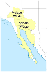
Deutsch: Karte: Lage der Sonoran- und der Mojavewüste |
| Date | see file history |
| Source |
Own work, using |
| Author | Maximilian Dörrbecker (Chumwa) |
| Permission (Reusing this file) |
This file is licensed under the Creative Commons Attribution-Share Alike 2.0 Generic license.
|
File history
Click on a date/time to view the file as it appeared at that time.
| Date/Time | Thumbnail | Dimensions | User | Comment | |
|---|---|---|---|---|---|
| current | 06:47, 12 November 2010 | | 457 × 690 (47 KB) | Chumwa (talk | contribs) | Farben geändert |
| 23:05, 11 November 2010 |  | 457 × 690 (42 KB) | Chumwa (talk | contribs) | Übergang zwischen USA und Mexiko noch etwas bereinigt | |
| 22:44, 11 November 2010 |  | 457 × 690 (42 KB) | Chumwa (talk | contribs) | {{Information |Description=??? |Author=Maximilian Dörrbecker (Chumwa) |Source={{own}}, using * Datei:Mojave-sonoran deserts.png * Mexico_location_map.svg by [[User:NordNordWes |
You cannot overwrite this file.
File usage on Commons
The following page uses this file:
File usage on other wikis
The following other wikis use this file:
- Usage on de.wikipedia.org