File:Mohun telegraph expedition.JPG
Jump to navigation
Jump to search
Size of this preview: 574 × 599 pixels. Other resolutions: 230 × 240 pixels | 460 × 480 pixels | 734 × 766 pixels.
Original file (734 × 766 pixels, file size: 199 KB, MIME type: image/jpeg)
Captions
Captions
Add a one-line explanation of what this file represents
| Description |
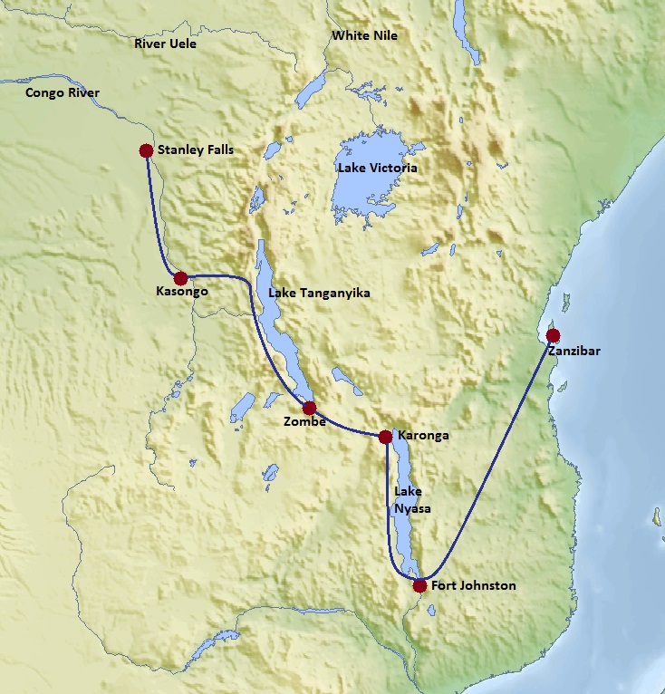
A map of the telegraph laying expedition made by Richard Mohun from 1898 to 1901. Based on a Topographic map of Africa with Cassini cylindrical projection |
| Date | (UTC) |
| Source | |
| Author |
|
I, the copyright holder of this work, hereby publish it under the following license:
The map has been created with the Generic Mapping Tools: https://www.generic-mapping-tools.org/ using one or more of these public-domain datasets for the relief:
|

|
Permission is granted to copy, distribute and/or modify this document under the terms of the GNU Free Documentation License, Version 1.2 or any later version published by the Free Software Foundation; with no Invariant Sections, no Front-Cover Texts, and no Back-Cover Texts. A copy of the license is included in the section entitled GNU Free Documentation License. |
| This file is licensed under the Creative Commons Attribution-Share Alike 3.0 Unported license. | ||
| ||
| This licensing tag was added to this file as part of the GFDL licensing update. |
Original upload log
[edit]
This image is a derivative work of the following images:
- Image:Africa_topography_map.png licensed with GFDL-GMT
- 2008-02-12T07:41:54Z Bamse 2663x2639 (1741458 Bytes)
- 2008-01-29T03:51:31Z Bamse 2663x2639 (1741651 Bytes)
- 2008-01-22T09:03:22Z Bamse 2663x2639 (1746527 Bytes)
- 2008-01-11T05:52:42Z Bamse 2728x2703 (1780923 Bytes)
- 2008-01-11T05:23:01Z Bamse 2728x2703 (1768967 Bytes)
- 2007-12-19T04:26:53Z Bamse 2500x2479 (2564098 Bytes) {{Information |Description=topographic map of Africa |Source=self-made |Date=19-12-2007 |Author= [[User:Bamse|Bamse]] |Permission= |other_versions= }} {{GFDL-GMT}}
Uploaded with derivativeFX
File history
Click on a date/time to view the file as it appeared at that time.
| Date/Time | Thumbnail | Dimensions | User | Comment | |
|---|---|---|---|---|---|
| current | 11:22, 11 October 2014 | | 734 × 766 (199 KB) | Dumelow (talk | contribs) | revised and corrected to match text |
| 14:15, 15 September 2008 |  | 770 × 758 (91 KB) | Dumelow (talk | contribs) | {{Information |Description=A map of the telegraph laying expedition made by Richard Mohun from 1898 to 1901. Based on a Topographic map of Africa with Cassini cylindrical projection |Source=*Image:Africa_topography_map.png |Date=2008-09-15 14:14 (U |
You cannot overwrite this file.
File usage on Commons
There are no pages that use this file.
File usage on other wikis
The following other wikis use this file:
- Usage on en.wikipedia.org
- Usage on he.wikipedia.org