File:Mohican distribution map.svg
Jump to navigation
Jump to search

Size of this PNG preview of this SVG file: 526 × 599 pixels. Other resolutions: 211 × 240 pixels | 421 × 480 pixels | 674 × 768 pixels | 899 × 1,024 pixels | 1,798 × 2,048 pixels | 1,121 × 1,277 pixels.
Original file (SVG file, nominally 1,121 × 1,277 pixels, file size: 696 KB)
Captions
Captions
Add a one-line explanation of what this file represents
Summary
[edit]
| Description |
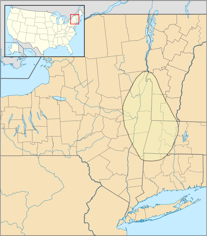
English: Approximate range of Mohican (Mahican) native americans |
| Date | |
| Source | Self created using Inkscape. Map outline is a composite of :file:US Locator Blank2.svg (Originally uploaded at English Wikipedia by en:User:Papayoung and en:User:Ilmari Karonen, modified by NordNordWest at Commons. Originally created by en:User:Wapcaplet), :file:USA New York location map.svg{NordNordWest at Commons), :file:USA Vermont location map.svg (Alexrk2 at Commons), :file:USA Massachusetts location map.svg (Alexrk2 at Commons) and :file:USA Connecticut location map.svg (Alexrk2 at Commons). The map data for the Mohican range was obtained from Native Languages of the Americas, "Mohican Culture and History" and the various map sub-pages there. |
| Author | SpinningSpark |
Licensing
[edit]
This file is licensed under the Creative Commons Attribution-Share Alike 3.0 Unported license.
Attribution: Courtesy Spinningspark at Wikipedia
- You are free:
- to share – to copy, distribute and transmit the work
- to remix – to adapt the work
- Under the following conditions:
- attribution – You must give appropriate credit, provide a link to the license, and indicate if changes were made. You may do so in any reasonable manner, but not in any way that suggests the licensor endorses you or your use.
- share alike – If you remix, transform, or build upon the material, you must distribute your contributions under the same or compatible license as the original.
Original upload log
[edit]
The original description page was here. All following user names refer to en.wikipedia.
| Date/Time | Dimensions | User | Comment |
|---|---|---|---|
| 2009-07-12 21:40 | 1121×1277× (712788 bytes) | Spinningspark | {{Information |Description=Approximate range of Mohican (Mahican) native americans |Source=Self created using Inkscape. Map outline is a composite of [[:file:US Locator Blank2.svg]] (Originally uploaded at English Wikipedia by en:User:Papayoung and en:Us |
File history
Click on a date/time to view the file as it appeared at that time.
| Date/Time | Thumbnail | Dimensions | User | Comment | |
|---|---|---|---|---|---|
| current | 15:32, 22 October 2015 | | 1,121 × 1,277 (696 KB) | Kopiersperre (talk | contribs) | Transferred from en.wikipedia |
You cannot overwrite this file.
File usage on Commons
There are no pages that use this file.
File usage on other wikis
The following other wikis use this file:
- Usage on ar.wikipedia.org
- Usage on azb.wikipedia.org
- Usage on az.wikipedia.org
- Usage on bg.wikipedia.org
- Usage on es.wikipedia.org
- Usage on fi.wikipedia.org
- Usage on gl.wikipedia.org
- Usage on nl.wikipedia.org
- Usage on no.wikipedia.org
- Usage on simple.wikipedia.org
- Usage on sr.wikipedia.org
- Usage on zh.wikipedia.org