File:Modliborzyce (gmina) location map.png
Original file (1,199 × 1,382 pixels, file size: 323 KB, MIME type: image/png)
Captions
Captions
Summary
[edit]_location_map.png&action=edit§ion=1)
| Description |
English: Location map |
| Date | |
| Source | Own work |
| Author | Smat |
| Description |
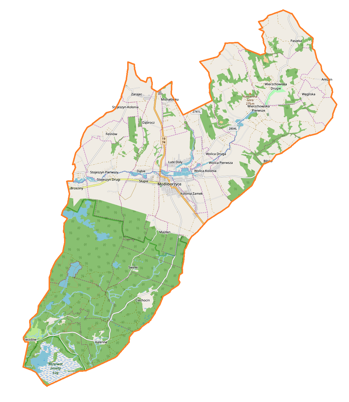
Polski: Mapa gminy Modliborzyce, Polska
English: Map of Modliborzyce (gmina), Poland |
|||||||||
| Date | ||||||||||
| Source | You may find a page on the OpenStreetMap wiki page for Modliborzyce (gmina) | |||||||||
| Creator |
OpenStreetMap contributors OpenStreetMap contributors |
|||||||||
| Permission (Reusing this file) |
OpenStreetMap data is available under the Open Database License (details). Map tiles are licensed under the Creative Commons Attribution-ShareAlike 2.0 license (CC-BY-SA 2.0).
This file is licensed under the Creative Commons Attribution-Share Alike 2.0 Generic license.
|
|||||||||
| Geotemporal data | ||||||||||
| Bounding box |
|
|||||||||
| Georeferencing | If inappropriate please set warp_status = skip to hide. | |||||||||
Licensing
[edit]_location_map.png&action=edit§ion=2)
| This work contains information from OpenStreetMap, which is made available under the Open Database License (ODbL).
The ODbL does not require any particular license for maps produced from ODbL data. Prior to 1 August 2020, map tiles produced by the OpenStreetMap Foundation were licensed under the CC-BY-SA-2.0 license. Maps produced by other people may be subject to other licences. |
File history
Click on a date/time to view the file as it appeared at that time.
| Date/Time | Thumbnail | Dimensions | User | Comment | |
|---|---|---|---|---|---|
| current | 12:31, 7 September 2017 | | 1,199 × 1,382 (323 KB) | Smat (talk | contribs) | User created page with UploadWizard |
You cannot overwrite this file.
File usage on Commons
There are no pages that use this file.
File usage on other wikis
The following other wikis use this file:
- Usage on pl.wikipedia.org
- Modliborzyce (gmina)
- Kalenne
- Kolonia Zamek
- Lute
- Stojeszyn Drugi
- Stojeszyn-Kolonia
- Stojeszyn Pierwszy
- Wolica Pierwsza
- Zarajec
- Bilsko (województwo lubelskie)
- Ciechocin (województwo lubelskie)
- Felinów (województwo lubelskie)
- Gwizdów (województwo lubelskie)
- Modliborzyce
- Słupie (województwo lubelskie)
- Świnki (województwo lubelskie)
- Węgliska (województwo lubelskie)
- Wierzchowiska Pierwsze (powiat janowski)
- Antolin (powiat janowski)
- Brzeziny (powiat janowski)
- Dąbie (powiat janowski)
- Majdan (powiat janowski)
- Michałówka (powiat janowski)
- Pasieka (powiat janowski)
- Wierzchowiska Drugie (powiat janowski)
- Wolica Druga
- Wikipedysta:Ziomalitto/brudnopis
- Wolica-Kolonia (powiat janowski)
- Parafia św. Stanisława w Modliborzycach
- Parafia Matki Bożej Nieustającej Pomocy w Wierzchowiskach Drugich
- Parafia Miłosierdzia Bożego w Brzezinach
- Kaplica Wspomożycielki Wiernych w Wolicy Pierwszej
- Cmentarz żydowski w Modliborzycach
- Synagoga w Modliborzycach
- Kościół św. Stanisława Biskupa i Męczennika w Modliborzycach
- Dąbrocz
- Krasonie
- Lute Doły
- Majdan-Kolonia
- Janówek (Modliborzyce)
- Moduł:Mapa/dane/Modliborzyce (gmina)
- Moduł:Mapa/dane/Modliborzyce
- Usage on pl.wikibooks.org
_location_map.png&oldid=720440930)