File:Modern jewellery hoard (FindID 188805).jpg
Jump to navigation
Jump to search
Size of this preview: 535 × 599 pixels. Other resolutions: 214 × 240 pixels | 428 × 480 pixels | 685 × 768 pixels | 1,179 × 1,321 pixels.
Original file (1,179 × 1,321 pixels, file size: 562 KB, MIME type: image/jpeg)
Captions
Captions
Add a one-line explanation of what this file represents
Summary
[edit].jpg&action=edit§ion=1)
| Modern jewellery hoard | |||
|---|---|---|---|
| Photographer |
Northamptonshire County Council, Steven Ashby, 2007-09-08 16:05:16 |
||
| Title |
Modern jewellery hoard |
||
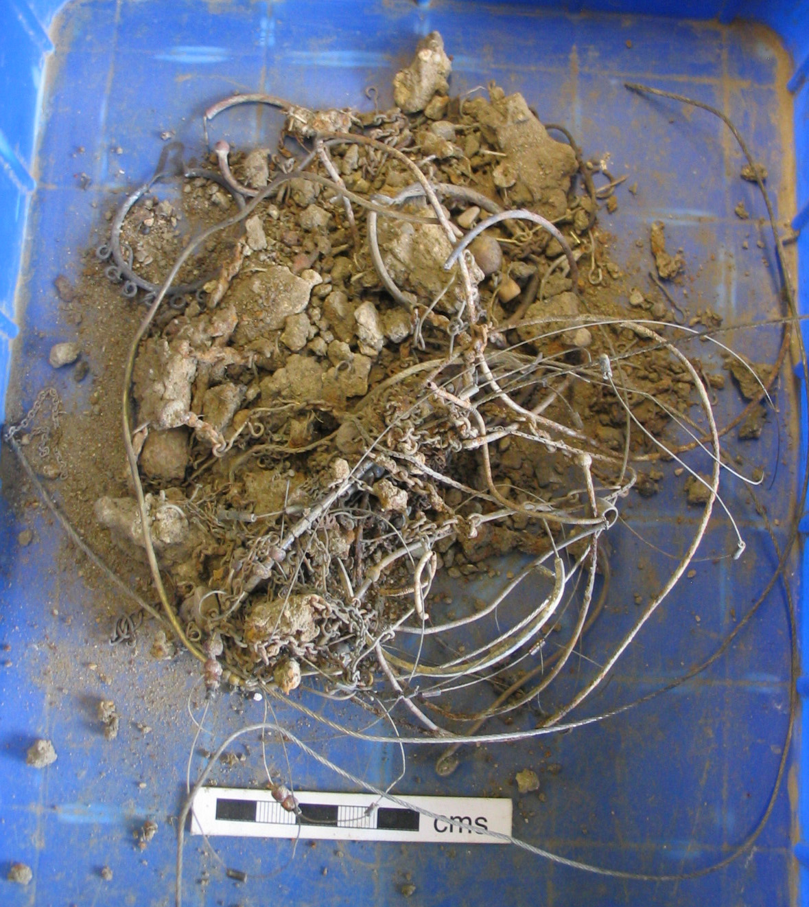
| Description |
English: A collection of Victorian jewellery, deposited as a 'hoard'. The deposit includes ear rings, necklaces, fragments from 'charm bracelets', and similar items. The metal is now very degraded and unidentifiable, but some of the bracelets bear copper alloy pendants and decorative stones (pebbles, rather than gemstones). The interest of this find lies in its mode of deposition; the entire collection was deposited in the ground, tangled together amongst metal wire. The reasons for such deposition remain unclear, but the action must have been deliberate, and an assoication with witchcraft cannot be ruled out. |
||
| Depicted place | (County of findspot) Northamptonshire | ||
| Date | between 1800 and 1930 | ||
| Accession number |
FindID: 188805 Old ref: NARC-249F97 Filename: NARC-249F97 jewellery hoard.JPG |
||
| Credit line |
|
||
| Source |
https://finds.org.uk/database/ajax/download/id/149544 Catalog: https://finds.org.uk/database/images/image/id/149544/recordtype/artefacts archive copy at the Wayback Machine Artefact: https://finds.org.uk/database/artefacts/record/id/188805 |
||
| Permission (Reusing this file) |
Attribution-ShareAlike License version 4.0 (verified 28 November 2020) | ||
| Object location | | View this and other nearby images on: OpenStreetMap |
|---|
.jpg¶ms=052.392400_N_-000.651485_E_globe:Earth_class:object_type:object__&language=en)
Licensing
[edit].jpg&action=edit§ion=2)
This file is licensed under the Creative Commons Attribution-Share Alike 4.0 International license.
Attribution: The Portable Antiquities Scheme/ The Trustees of the British Museum
- You are free:
- to share – to copy, distribute and transmit the work
- to remix – to adapt the work
- Under the following conditions:
- attribution – You must give appropriate credit, provide a link to the license, and indicate if changes were made. You may do so in any reasonable manner, but not in any way that suggests the licensor endorses you or your use.
- share alike – If you remix, transform, or build upon the material, you must distribute your contributions under the same or compatible license as the original.
File history
Click on a date/time to view the file as it appeared at that time.
| Date/Time | Thumbnail | Dimensions | User | Comment | |
|---|---|---|---|---|---|
| current | 23:17, 4 February 2017 | | 1,179 × 1,321 (562 KB) | Fæ (talk | contribs) | Portable Antiquities Scheme, RESEARCH, FindID: 188805, modern, page 5111, batch sort-updated count 52287 |
You cannot overwrite this file.
File usage on Commons
The following page uses this file:
.jpg)
.jpg&oldid=816097097)