File:Možděnice, CZ180304-001.jpg
Jump to navigation
Jump to search

Size of this preview: 800 × 431 pixels. Other resolutions: 320 × 172 pixels | 640 × 345 pixels | 1,024 × 552 pixels | 1,280 × 690 pixels | 2,560 × 1,380 pixels | 4,823 × 2,599 pixels.
Original file (4,823 × 2,599 pixels, file size: 2.69 MB, MIME type: image/jpeg)
Captions
Captions
Add a one-line explanation of what this file represents
Summary
[edit]
| Description |
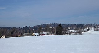
English: The small hamlet of "Možděnice", part of village "Vysočina", lies below the Zuberský hill (651 m above sea level), south of the peak. The constructions at an altitude of about 560-580 m along the nameless watercourse, the source of "Dlouhý potok" (the buildings in the north part of the village on the photo on the left). The boundary between geomorphological districts runs in the slope of the hill, below the "Stružinecká" knoll hill (the hamlet of "Možděnice"), the top part lies in the "Kameničská" Highlands (the nature reserve of "Zubří" on a hill southwest under the top on the cadastral territory "Trhová Kamenice"). Photo location: Czechia, Pardubice Region, municipality Vysočina, the hamlet of "Možděnice", "Stružinecká" knoll hill.
Čeština: Malá vesnice Možděnice, část obce Vysočina, leží pod Zuberským vrchem (651 m n. m.), jižně od vrcholu. Zástavba v nadmořské výšce cca 560–580 m podél bezejmenného vodního toku, zdrojnice Dlouhého potoka (část zástavby v severní části vesnice na fotografii vlevo). Svahem kopce probíhá hranice mezi geomorfologickými okrsky, dole Stružinecká pahorkatina (vesnice Možděnice) a vrcholová část v Kameničské vrchovině (přírodní rezervace Zubří ve svahu jihozápadně pod vrcholem na katastrálním území Trhová Kamenice). Foto lokace: Česko, Pardubický kraj, obec Vysočina, vesnice Možděnice, Stružinecká pahorkatina (333°). |
| Date | |
| Source | Own work |
| Author | Josef Kreuz (PEPan) |
| Camera location | | View this and other nearby images on: OpenStreetMap |
|---|
Zdroje informací:
[edit]
- ČÚZK, základní mapa ČR – kompozice Možděnice a Zubří viz
- AOPK ČR, přírodní poměry / geomorfologie – aplikace MapoMat viz
- AOPK ČR, ústřední seznam ochrany přírody – přírodní rezervace Zubří viz
- Mapy.cz, turistická mapa (letecký pohled) – Možděnice, Zubří, Zuberský vrch viz
Licensing
[edit]
I, the copyright holder of this work, hereby publish it under the following license:
This file is licensed under the Creative Commons Attribution-Share Alike 4.0 International license.
- You are free:
- to share – to copy, distribute and transmit the work
- to remix – to adapt the work
- Under the following conditions:
- attribution – You must give appropriate credit, provide a link to the license, and indicate if changes were made. You may do so in any reasonable manner, but not in any way that suggests the licensor endorses you or your use.
- share alike – If you remix, transform, or build upon the material, you must distribute your contributions under the same or compatible license as the original.
File history
Click on a date/time to view the file as it appeared at that time.
| Date/Time | Thumbnail | Dimensions | User | Comment | |
|---|---|---|---|---|---|
| current | 13:21, 20 March 2018 | | 4,823 × 2,599 (2.69 MB) | PEPan (talk | contribs) | User created page with UploadWizard |
You cannot overwrite this file.
File usage on Commons
There are no pages that use this file.
File usage on other wikis
The following other wikis use this file:
- Usage on cs.wikipedia.org