File:Mlekojedy LT CZ wayside cross besides Litomerice road 135.jpg
From Wikimedia Commons, the free media repository
Jump to navigation
Jump to search

Size of this preview: 450 × 600 pixels. Other resolutions: 180 × 240 pixels | 360 × 480 pixels | 576 × 768 pixels | 768 × 1,024 pixels | 1,488 × 1,984 pixels.
Original file (1,488 × 1,984 pixels, file size: 678 KB, MIME type: image/jpeg)
File information
Structured data
Captions
Captions
Add a one-line explanation of what this file represents
| DescriptionMlekojedy LT CZ wayside cross besides Litomerice road 135.jpg |
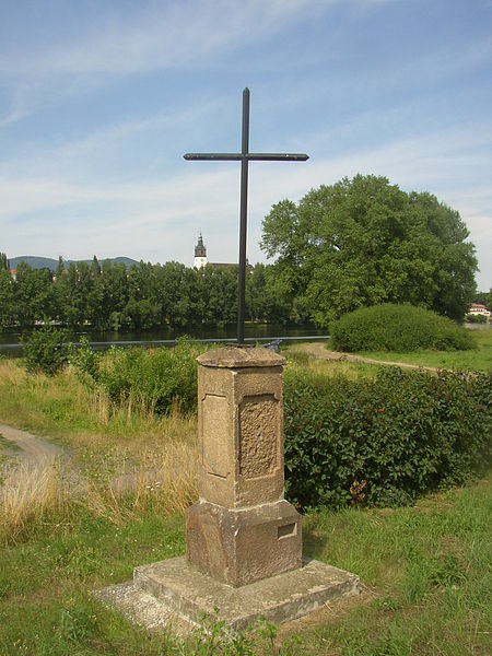
Čeština: Mlékojedy, okres Litoměřice. Křížek při silnici na východním konci obce, naproti fotbalovému hřišti. Pohled z jihozápadní strany, v pozadí řeka Labe, za stromy se skrývá město Litoměřice, z něhož patrná pouze zvonice při katedrále sv. Štěpána.
English: Mlékojedy, Litoměřice District, Czech Republic. Wayside cross besides main road in eastern end of the village, opposite to football field. A view from the southwest, in the background the Elbe River and town of Litoměřice the trees, belfry of St Stephen's being its only visible landmark. |
| Date | |
| Source | Own work |
| Author | User:Miaow Miaow |
| Permission (Reusing this file) |
PD-self |
| Other versions |
|
| Camera location | 50° 31′ 38.2″ N, 14° 07′ 21.3″ E | View this and other nearby images on: OpenStreetMap |
|---|
(coord. nccuracy probably up to ±5 m, est. error in the worst case ±15 m)
| Public domainPublic domainfalsefalse |
| I, the copyright holder of this work, release this work into the public domain. This applies worldwide. In some countries this may not be legally possible; if so: I grant anyone the right to use this work for any purpose, without any conditions, unless such conditions are required by law. |
File history
Click on a date/time to view the file as it appeared at that time.
| Date/Time | Thumbnail | Dimensions | User | Comment | |
|---|---|---|---|---|---|
| current | 20:53, 21 July 2008 |  | 1,488 × 1,984 (678 KB) | Miaow Miaow (talk | contribs) | {{Information |Description= {{cs|'''Mlékojedy''', okres Litoměřice. Křížek při silnici na východním konci obce, naproti fotbalovému hřišti. Pohled z jihozápadní strany, v pozadí řeka Labe, za stromy se skrývá město Li |
You cannot overwrite this file.
File usage on Commons
The following 2 pages use this file:
File usage on other wikis
The following other wikis use this file:
- Usage on cs.wikipedia.org
- Usage on www.wikidata.org
Metadata
This file contains additional information such as Exif metadata which may have been added by the digital camera, scanner, or software program used to create or digitize it. If the file has been modified from its original state, some details such as the timestamp may not fully reflect those of the original file. The timestamp is only as accurate as the clock in the camera, and it may be completely wrong.
| Image title | OLYMPUS DIGITAL CAMERA |
|---|---|
| Camera manufacturer | OLYMPUS OPTICAL CO.,LTD |
| Camera model | C300Z,D550Z |
| Exposure time | 1/320 sec (0.003125) |
| F-number | f/5.6 |
| ISO speed rating | 60 |
| Date and time of data generation | 15:36, 6 July 2008 |
| Lens focal length | 6 mm |
| Horizontal resolution | 72 dpi |
| Vertical resolution | 72 dpi |
| Software used | v574p-76 |
| File change date and time | 15:36, 6 July 2008 |
| Y and C positioning | Co-sited |
| Exposure Program | Creative program (biased toward depth of field) |
| Exif version | 2.1 |
| Date and time of digitizing | 15:36, 6 July 2008 |
| Meaning of each component |
|
| Image compression mode | 1 |
| APEX exposure bias | 0 |
| Maximum land aperture | 3.1 APEX (f/2.93) |
| Metering mode | Pattern |
| Light source | Unknown |
| Flash | Flash did not fire |
| Supported Flashpix version | 1 |
| Color space | sRGB |
| File source | Digital still camera |
| Scene type | A directly photographed image |

