File:MittelheimHochwasserB42AbgesenkterAbschnitt.jpg
Jump to navigation
Jump to search

Size of this preview: 800 × 600 pixels. Other resolutions: 320 × 240 pixels | 640 × 480 pixels | 1,024 × 768 pixels | 1,280 × 960 pixels | 2,560 × 1,920 pixels | 3,072 × 2,304 pixels.
Original file (3,072 × 2,304 pixels, file size: 1.41 MB, MIME type: image/jpeg)
Captions
Captions
Add a one-line explanation of what this file represents
Summary
[edit]
| Description |
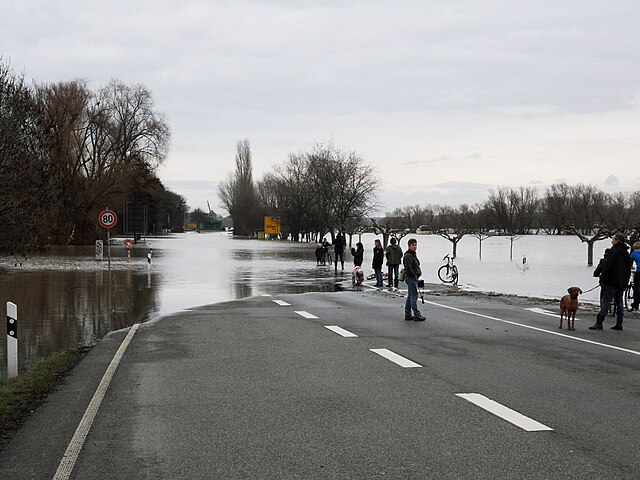
Deutsch: Blick von der Abfahrt Mittelheim am Nikolauspfad auf den Abschnitt der Bundesstraße 42, der abgesenkt ist und deshalb rheingauweit als erster überflutet wird, beim Pegelstand 499 um 13:00 Uhr am Rheinpegel Oestrich, Tendenz steigend, Schiffahrt eingestellt. Im Hintergrund der Oestricher Kran. Das Hochwasser steht am tiefsten Punkt schon mehr als einen halben Meter hoch auf der Fahrbahn, denn ab Pegelstand Bingen 460, der zeitgleich etwa dem Pegelstand Oestrich 438 entspricht, „erreicht das Hochwasser die B42“ (Wiesbadener Kurier vom 5. Januar 2018). |
| Date | Taken on 15 January 2011 |
| Source | Own work |
| Author | Brühl |
Licensing
[edit]
I, the copyright holder of this work, hereby publish it under the following license:
This file is licensed under the Creative Commons Attribution-Share Alike 3.0 Germany license.
- You are free:
- to share – to copy, distribute and transmit the work
- to remix – to adapt the work
- Under the following conditions:
- attribution – You must give appropriate credit, provide a link to the license, and indicate if changes were made. You may do so in any reasonable manner, but not in any way that suggests the licensor endorses you or your use.
- share alike – If you remix, transform, or build upon the material, you must distribute your contributions under the same or compatible license as the original.

File history
Click on a date/time to view the file as it appeared at that time.
| Date/Time | Thumbnail | Dimensions | User | Comment | |
|---|---|---|---|---|---|
| current | 17:48, 14 December 2023 | | 3,072 × 2,304 (1.41 MB) | Brühl (talk | contribs) | == {{int:filedesc}} == {{Information |Description={{de|1= Blick von der Abfahrt Mittelheim am Nikolauspfad auf den Abschnitt der Bundesstraße 42, der abgesenkt ist und deshalb rheingauweit als erster überflutet wird, beim Pegelstand 499 um 13:00 Uhr am Rheinpegel Oestrich, Tendenz steigend, Schiffahrt eingestellt. Im Hintergrund der Oestricher Kran. Das Hochwasser steht am tiefsten Punkt schon mehr als einen halben Meter hoch auf der Fahrbahn, denn ab Pegelstand Bingen 460, der zeitgleich etw... |
You cannot overwrite this file.
File usage on Commons
The following page uses this file:
- File:SDC13754 MittelheimHochwasserB42AbgesenkterAbschnitt.JPG (file redirect)
File usage on other wikis
The following other wikis use this file:
- Usage on de.wikipedia.org