File:Mitchell Monument, Bly, Oregon (6150418476).jpg

Original file (2,736 × 3,648 pixels, file size: 6.42 MB, MIME type: image/jpeg)
Captions
Captions
Summary
[edit].jpg&action=edit§ion=1)
| Description |
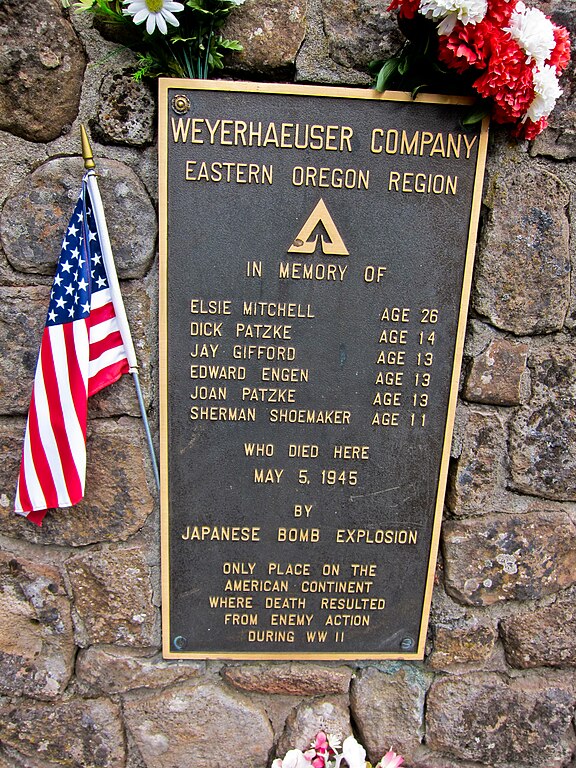
Mitchell Recreation Area is a small picnic area near Bly, Oregon, United States. It is also known as Mitchell Monument. It is the only location in the continental U.S. where Americans were killed during World War II as a direct result of enemy action. The deaths were caused by a Japanese balloon bomb. The site is maintained by the United States Forest Service and is listed on the National Register of Historic Places. From Wikipedia: en.wikipedia.org/wiki/Mitchell_Recreation_Area On May 5, 1945, a pregnant woman and five children were killed when they discovered a balloon bomb that had landed in the forest of Gearhart Mountain in Southern Oregon. Pastor Archie Mitchell and his pregnant wife Elsye (or Elsie) drove up to Gearhart Mountain with five of their Sunday school students (aged 11–14) to have a picnic, and Elsye and the children got out of the car at Bly, Oregon, while Archie drove on to find a parking spot. As Elsye and the children looked for a good picnic spot, they saw a strange balloon lying on the ground. As the group approached the balloon, a bomb attached to it exploded and Elsye and all five children were killed. Archie witnessed the explosion and immediately ran to the scene and used his hands to extinguish the fire on his wife's and the children's clothing, but he could not save them. These are the only known deaths caused by the balloon bombs, and also the only known deaths in the continental U.S. as the result of enemy action during World War II. Military personnel arrived on the scene within hours, and saw that the balloon itself still had snow underneath it, while the surrounding area did not. They concluded that the balloon bomb had drifted to the ground several weeks earlier, and had lain there undisturbed until found by the group. Elyse Mitchell is buried in the Ocean View Cemetery in Port Angeles, Washington. A memorial, the Mitchell Monument, is located at the point of the explosion, 110 kilometers (70 mi) northeast of Klamath Falls in the Mitchell Recreation Area. It was listed in the National Register of Historic Places in 2001. Several Japanese civilians have visited the monument to offer their apologies for the deaths that took place here, and several cherry trees have been planted around the monument as a symbol of peace. Hundreds of balloon bombs may have landed but were never found and may still constitute unexploded ordnance. |
| Date | |
| Source | Mitchell Monument, Bly, Oregon |
| Author | Michael (a.k.a. moik) McCullough from Klamath Falls, Oregon, USA |
| Camera location | | View this and other nearby images on: OpenStreetMap |
|---|
.jpg¶ms=042.428244_N_-120.911407_E_globe:Earth_type:camera_source:Flickr_&language=en)
Licensing
[edit].jpg&action=edit§ion=2)
- You are free:
- to share – to copy, distribute and transmit the work
- to remix – to adapt the work
- Under the following conditions:
- attribution – You must give appropriate credit, provide a link to the license, and indicate if changes were made. You may do so in any reasonable manner, but not in any way that suggests the licensor endorses you or your use.
| This image was originally posted to Flickr by ex_magician at https://flickr.com/photos/37882873@N00/6150418476. It was reviewed on 29 April 2017 by FlickreviewR and was confirmed to be licensed under the terms of the cc-by-2.0. |
File history
Click on a date/time to view the file as it appeared at that time.
| Date/Time | Thumbnail | Dimensions | User | Comment | |
|---|---|---|---|---|---|
| current | 06:03, 29 April 2017 | | 2,736 × 3,648 (6.42 MB) | Mliu92 (talk | contribs) | Transferred from Flickr via Flickr2Commons |
You cannot overwrite this file.
File usage on Commons
The following page uses this file:
.jpg&oldid=454736267)