File:Mississippi Valley Division US Army Corps of Engineers Districts Map.jpg
Jump to navigation
Jump to search

Size of this preview: 363 × 599 pixels. Other resolutions: 145 × 240 pixels | 476 × 786 pixels.
Original file (476 × 786 pixels, file size: 141 KB, MIME type: image/jpeg)
Captions
Captions
Add a one-line explanation of what this file represents
| Description |
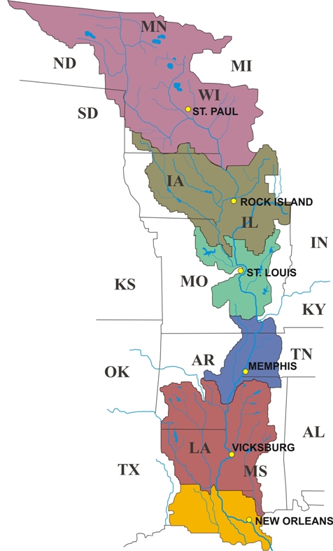
English: This depicts the areas of responsibility for the six Districts which comprise the Mississippi Valley Division of the US Army Corps of Engineers. Current as of September 2014. |
| Source | http://www.mvd.usace.army.mil/portals/52/siteimages/MVD_districts.jpg |
| Author | USACE |
| Permission (Reusing this file) |
http://www.mvd.usace.army.mil/portals/52/siteimages/MVD_districts.jpg this is the US Federal Government |
- Other information
English: This is created by USACE of the US Federal Government.
| This work has been released into the public domain by its author, USACE. This applies worldwide. In some countries this may not be legally possible; if so: USACE grants anyone the right to use this work for any purpose, without any conditions, unless such conditions are required by law.
|
File history
Click on a date/time to view the file as it appeared at that time.
| Date/Time | Thumbnail | Dimensions | User | Comment | |
|---|---|---|---|---|---|
| current | 04:15, 5 September 2014 | | 476 × 786 (141 KB) | WIKI1Q2W3E4R (talk | contribs) | {{subst:Upload marker added by en.wp UW}} {{Information |Description = {{en|This depicts the areas of responsibility for the six Districts which comprise the Mississippi Valley Division of the US Army Corps of Engineers. Current as of September 2014.}}... |
You cannot overwrite this file.
File usage on Commons
There are no pages that use this file.
File usage on other wikis
The following other wikis use this file:
- Usage on en.wikipedia.org