File:Mining operation, Prophyry dike, Chititu Creek, 1916 (AL+CA 368).jpg
Mining_operation,_Prophyry_dike,_Chititu_Creek,_1916_(AL+CA_368).jpg (768 × 476 pixels, file size: 77 KB, MIME type: image/jpeg)
Captions
Captions

|
The categories of this image need checking. You can do so here.
|
.jpg&action=edit&withJS=MediaWiki:Catcheck.js)
Summary
[edit].jpg&action=edit§ion=1)
| English: Mining operation, Prophyry dike, Chititu Creek, 1916
( |
||||||||||||||||||||||||
|---|---|---|---|---|---|---|---|---|---|---|---|---|---|---|---|---|---|---|---|---|---|---|---|---|
| Photographer |
Unknown author |
|||||||||||||||||||||||
| Title |
English: Mining operation, Prophyry dike, Chititu Creek, 1916 |
|||||||||||||||||||||||
| Description |
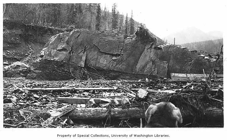
English: On verso of image: Porphyry dike. Lower end, No. 7, Chititu, 1916. See outline of human profile, 1 inch from right [drawings on wall?] Filed in Alaska--Rivers--Chititu Creek Chititu Creek flows northwest 7 miles to Nizina River, 9 miles southeast of McCarthy. This Indian name was reported in 1885 to mean "copper water." It was so named because of its dark brown (or copper) color. [Source: Donald Orth. Dictionary of Alaska Place Names: Geological Survey Professional Paper 567. Washington: United States Government Printing Office, 1967.
|
|||||||||||||||||||||||
| Depicted place |
English: United States--Alaska--Chititu Creek |
|||||||||||||||||||||||
| Date | 1916 | |||||||||||||||||||||||
| Collection |
|
|||||||||||||||||||||||
| Current location | ||||||||||||||||||||||||
| Accession number | ||||||||||||||||||||||||
| Source | ||||||||||||||||||||||||
| Permission (Reusing this file) |
|
|||||||||||||||||||||||
| Order Number | AWC0460 | |||||||||||||||||||||||
File history
Click on a date/time to view the file as it appeared at that time.
| Date/Time | Thumbnail | Dimensions | User | Comment | |
|---|---|---|---|---|---|
| current | 07:27, 25 March 2019 | | 768 × 476 (77 KB) | BMacZeroBot (talk | contribs) | (BOT) batch upload |
You cannot overwrite this file.
File usage on Commons
The following 2 pages use this file:
.jpg)
.jpg&oldid=707140884)