File:Mini Delta pylon 150 kV Grimbergen BE 2010.jpg
Jump to navigation
Jump to search

Size of this preview: 450 × 600 pixels. Other resolutions: 180 × 240 pixels | 360 × 480 pixels | 576 × 768 pixels | 768 × 1,024 pixels | 1,536 × 2,048 pixels | 2,736 × 3,648 pixels.
Original file (2,736 × 3,648 pixels, file size: 6.27 MB, MIME type: image/jpeg)
Captions
Captions
Add a one-line explanation of what this file represents
| Description |
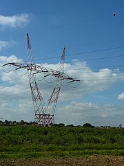
English: Mini Delta pylon of the 150 kV power line between Breugel substation (Grand-Bigard) and Verbrande Brug powerstation (Vilvoorde); Grimbergen (Belgium). The pylon was minimized in height due to the proximity of Brussels National Airport (ca. 6 km) and Grimbergen Airfield (ca. 2 km).
Nederlands: Mini Delta mast van de 150 kV lijn tussen hoogspanningsstation Breugel (Groot-Bijgaarden) en electriciteitscentrale Verbrande Brug (Vilvoorde); Grimbergen. Toren en broekstuk van de mast werden zo klein gemaakt vanwege de nabijheid van Nationale Luchthaven Brussel-Zaventem (op 6 km) en Grimbergen Vliegveld (op 2 km). |
||
| Date | |||
| Source | Mini Delta-Pylon | ||
| Author | Luc.T | ||
| Permission (Reusing this file) |
This file is licensed under the Creative Commons Attribution 2.0 Generic license. Attribution: Luc.T
|
||
| Other versions |
|

| Camera location | | View this and other nearby images on: OpenStreetMap |
|---|
File history
Click on a date/time to view the file as it appeared at that time.
| Date/Time | Thumbnail | Dimensions | User | Comment | |
|---|---|---|---|---|---|
| current | 18:12, 28 September 2017 | | 2,736 × 3,648 (6.27 MB) | Te750iv (talk | contribs) | {{Information |Description={{en|1=Mini Delta pylon of the 150 kV power line between Breugel substation (Grand-Bigard) and Verbrande Brug powerstation (Vilvoorde); Grimbergen (Belgium). The pylon was minimized in height due to the proximity of Brussels... |
You cannot overwrite this file.
File usage on Commons
The following page uses this file:
File usage on other wikis
The following other wikis use this file:
- Usage on ja.wikipedia.org
- Usage on nl.wikipedia.org