File:Mindel Donau catchment.png
Jump to navigation
Jump to search

Size of this preview: 355 × 599 pixels. Other resolutions: 142 × 240 pixels | 284 × 480 pixels | 640 × 1,080 pixels.
Original file (640 × 1,080 pixels, file size: 744 KB, MIME type: image/png)
Captions
Captions
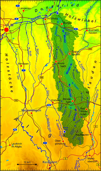
Catchment area of the Mindel river. In the hatched area the runoff is mostly channeled.
Summary
[edit]
| Description | |
| Date | |
| Source | Own work |
| Author | Periphrastika |
Own work based on ASTER Digital Elevation Model data by https://lpdaac.usgs.gov/ and own runoff calculation. Geographical data provided by OpenStreetMap and contributors.
Licensing
[edit]
I, the copyright holder of this work, hereby publish it under the following license:
This file is licensed under the Creative Commons Attribution-Share Alike 4.0 International license.
- You are free:
- to share – to copy, distribute and transmit the work
- to remix – to adapt the work
- Under the following conditions:
- attribution – You must give appropriate credit, provide a link to the license, and indicate if changes were made. You may do so in any reasonable manner, but not in any way that suggests the licensor endorses you or your use.
- share alike – If you remix, transform, or build upon the material, you must distribute your contributions under the same or compatible license as the original.
File history
Click on a date/time to view the file as it appeared at that time.
| Date/Time | Thumbnail | Dimensions | User | Comment | |
|---|---|---|---|---|---|
| current | 15:47, 6 March 2021 | | 640 × 1,080 (744 KB) | Periphrastika (talk | contribs) | Uploaded own work with UploadWizard |
You cannot overwrite this file.
File usage on Commons
The following 3 pages use this file:
File usage on other wikis
The following other wikis use this file: