File:MinasGerais Municip Bugre.svg
Jump to navigation
Jump to search

Size of this PNG preview of this SVG file: 773 × 600 pixels. Other resolutions: 310 × 240 pixels | 619 × 480 pixels | 990 × 768 pixels | 1,280 × 993 pixels | 2,560 × 1,986 pixels | 914 × 709 pixels.
Original file (SVG file, nominally 914 × 709 pixels, file size: 2.43 MB)
Captions
Captions
Add a one-line explanation of what this file represents

|
Standardization of derivative maps
Feel free to create derivations of this work, but if you want to illustrate a Wikipedia article with derivative works of this or similar maps of Brazil, please strictly follow the visual standard, nomenclature and classification already in use. All maps of Brazilian subdivisions are being adaptated or created in this way. We do not want to inhibit creativity but the pattern adopted here was presented and accepted by the Lusophone community and should be followed whenever possible. |
Summary
[edit]
| Description |
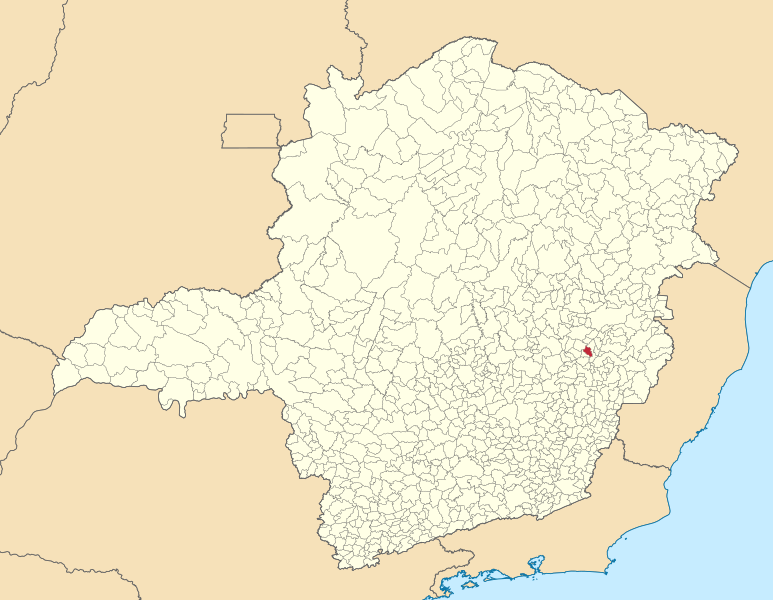
English: Location map of the municipality of Bugre in Minas Gerais state, Brazil.
Português: Localização do município de Bugre no estado de Minas Gerais, Brasil. |
| Date | |
| Source | File:Brazil Minas Gerais location map.svg (derivate for File:MinasGerais MesoMicroMunicip.svg) |
| Author |
Licensing
[edit]
This file is licensed under the Creative Commons Attribution 2.5 Generic license.
- You are free:
- to share – to copy, distribute and transmit the work
- to remix – to adapt the work
- Under the following conditions:
- attribution – You must give appropriate credit, provide a link to the license, and indicate if changes were made. You may do so in any reasonable manner, but not in any way that suggests the licensor endorses you or your use.
File history
Click on a date/time to view the file as it appeared at that time.
| Date/Time | Thumbnail | Dimensions | User | Comment | |
|---|---|---|---|---|---|
| current | 17:54, 31 December 2018 | | 914 × 709 (2.43 MB) | HVL (talk | contribs) | Removing regional division extinguished |
| 05:41, 28 August 2006 |  | 914 × 709 (1.91 MB) | Raphael.lorenzeto (talk | contribs) | {{Information| |Description=Map locator of a city in Minas Gerais (this description will be changed) |Source=Image:MinasGerais MesoMicroMunicip.svg, own work |Date=August 27, 2006 |Author=Raphael Lorenzeto de Abreu |Permission={{self2|GFDL|cc-by-2.5} |
You cannot overwrite this file.
File usage on Commons
The following page uses this file:
File usage on other wikis
The following other wikis use this file:
- Usage on ar.wikipedia.org
- Usage on bpy.wikipedia.org
- Usage on eo.wikipedia.org
- Usage on eu.wikipedia.org
- Usage on it.wikipedia.org
- Usage on nl.wikipedia.org
- Usage on no.wikipedia.org
- Usage on pt.wikipedia.org
- Usage on ro.wikipedia.org
- Usage on tt.wikipedia.org
- Usage on vi.wikipedia.org
- Usage on www.wikidata.org
- Usage on zh-min-nan.wikipedia.org
- Usage on zh.wikipedia.org